
St. Lucie County is located in the southeastern portion of the U.S. state of Florida. As of the 2020 census, the population was 329,226. The county's seat is Fort Pierce, while the largest city is Port St. Lucie, making up 62% of the county's population. St. Lucie County is the principal county of the Port St. Lucie, FL Metropolitan Statistical Area.

The Seminole Wars were a series of three military conflicts between the United States and the Seminoles that took place in Florida between about 1816 and 1858. The Seminoles are a Native American nation which coalesced in northern Florida during the early 1700s, when the territory was still a Spanish colonial possession. Tensions grew between the Seminoles and settlers in the newly independent United States in the early 1800s, mainly because enslaved people regularly fled from Georgia into Spanish Florida, prompting slaveowners to conduct slave raids across the border. A series of cross-border skirmishes escalated into the First Seminole War in 1817, when General Andrew Jackson led an incursion into the territory over Spanish objections. Jackson's forces destroyed several Seminole and Black Seminole towns and briefly occupied Pensacola before withdrawing in 1818. The U.S. and Spain soon negotiated the transfer of the territory with the Adams-Onis Treaty of 1819.

Prospect Bluff Historic Sites is located in Franklin County, Florida, on the Apalachicola River, 6 miles (9.7 km) SW of Sumatra, Florida. The site contains the ruins of two forts.

The Black Seminoles, or Afro-Seminoles, are an ethnic group of mixed Native American and African origin associated with the Seminole people in Florida and Oklahoma. They are mostly blood descendants of the Seminole people, free Africans, and escaped former slaves, who allied with Seminole groups in Spanish Florida. Many have Seminole lineage, but due to the stigma of having mixed origin, they have all been categorized as slaves or freedmen in the past.
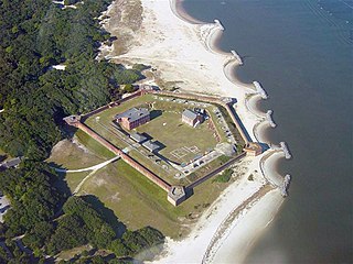
Fort Clinch is a 19th-century masonry coastal fortification, built as part of the Third System of seacoast defense conceived by the United States. It is located on a peninsula near the northernmost point of Amelia Island in Nassau County, Florida. The fort lies to the northeast of Fernandina Beach at the entrance to the Cumberland Sound, in the northeast part of the state. Today it is included within the boundaries of Fort Clinch State Park.

The Ais or Ays were a Native American people of eastern Florida. Their territory included coastal areas and islands from approximately Cape Canaveral to the Indian River. The Ais chiefdom consisted of a number of towns, each led by a chief who was subordinate to the paramount chief of Ais; the Indian River was known as the "River of Ais" to the Spanish. The Ais language has been linked to the Chitimacha language by linguist Julian Granberry, who points out that "Ais" means "the people" in the Chitimacha language. The Ais were hunter-gatherers and food was plentiful. They ate fish, turtle, shellfish, cocoplums, sabal palm berries and other gathered fruits. Prior to contact with European colonizers, the Ais population had grown to several hundred thousand and may have flourished for over 10,000 years.
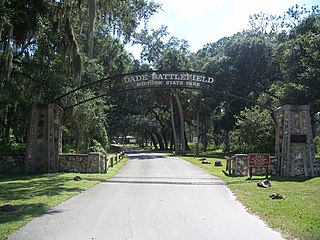
Dade Battlefield Historic State Park is a state park located on County Road 603 between Interstate 75 and U.S. Route 301 in Sumter County, Florida. The 80-acre (32 ha) park includes 40 acres (160,000 m2) of pine flatwoods and a live oak hammock. Also called the Dade Massacre site, it preserves the Second Seminole War battlefield where tribal Seminole warriors fought soldiers under the command of Major Francis L. Dade on December 28, 1835. Each year, on the weekend after Christmas, the Dade Battlefield Society sponsors a reenactment of the battle that started the Second Seminole War.
Paynes Creek Historic State Park is a Florida State Park located on Lake Branch Road one-half mile southeast of Bowling Green, Florida. On November 21, 1978, it was added to the United States National Register of Historic Places, under the title of Payne's Creek Massacre-Fort Chokonikla Site.

Mosquito County is the historic name of an early county that once comprised most of the eastern part of Florida. Its land included all of present-day Volusia, Brevard, Indian River, St. Lucie, Martin, Seminole, Osceola, Orange, Lake, Polk and Palm Beach counties.

The St. Lucie Village Historic District is a historic district located in St. Lucie Village, Florida. The district runs from 2505 through 3305 North Indian River Drive. Out of the 50 structures lining the Indian River Drive, 35 are of historical interest with the contributing structures ranging from Frame Vernacular to Late Victorian architecture. On December 1, 1989, the historic district was added to the National Register of Historic Places for its architectural and historical significance.

Fort Foster is a Second Seminole War era fort in central Florida, located 9 miles (14 km) south of current-day Zephyrhills in Pasco County.

Fort King was a United States military fort in north central Florida, near what later developed as the city of Ocala. It was named after Colonel William King, commander of Florida's Fourth Infantry and the first governor of the provisional West Florida region.
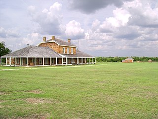
Fort Richardson was a United States Army installation located in present-day Jacksboro, Texas. Named in honor of Union General Israel B. Richardson, who died in the Battle of Antietam during the American Civil War, it was active from 1867 to 1878. Today, the site, with a few surviving buildings, is called Fort Richardson State Park, Historic Site and Lost Creek Reservoir State Trailway. It was designated a National Historic Landmark in 1963 for its role in securing the state's northern frontier in the post-Civil War era.

Fort Omaha, originally known as Sherman Barracks and then Omaha Barracks, is an Indian War-era United States Army supply installation. Located at 5730 North 30th Street, with the entrance at North 30th and Fort Streets in modern-day North Omaha, Nebraska, the facility is primarily occupied by the Metropolitan Community College. A Navy Operational Support Center and Marine Corps Reserve unit, along with an Army Reserve unit occupy the periphery of the 82.5 acres (33.4 ha) fort. The government deeded all but four parcels of the land to the Metropolitan Community College in 1974.
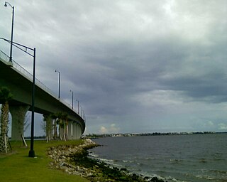
North Hutchinson Island is a coastal barrier island in Indian River and St. Lucie counties on the east coast of Florida in the United States. The island is adjacent to the Atlantic Ocean and is separated from the mainland on the west by the Indian River Lagoon. The portion of the island in Indian River County is known as Orchid Island.

The Battles of the Loxahatchee occurred west of what is now Jupiter, Florida in January 1838 between the United States military and the Seminole Indians. The First Battle of the Loxahatchee occurred on January 15, involving a mixed Navy-Army unit under Lt. Levin M. Powell. The Second Battle of the Loxahatchee occurred on January 24 involving an army under Major General Thomas Jesup. The two battles were fought within a few miles of each other against the same group of Seminoles.

This is a timeline of the U.S. state of Florida.
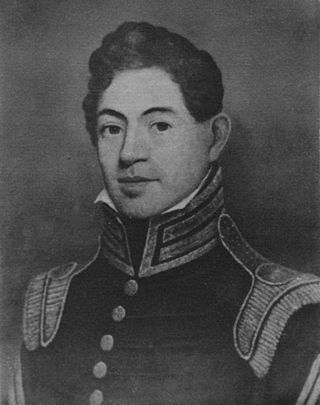
Benjamin Kendrick Pierce was a career officer in the United States Army. He was a son of New Hampshire Governor Benjamin Pierce and brother of President Franklin Pierce. Benjamin K. Pierce was a veteran of the War of 1812, the Second Seminole War, and the Mexican–American War, and rose to the rank of lieutenant colonel in the Army and colonel in the Florida Militia.

Fort Basinger's original site is located approximately 35 miles (56 km) west of Fort Pierce, Florida, along U. S. Highway 98 in Highlands County, Florida. It was a stockaded fortification with two blockhouses that was built in 1837 by the United States Army. It was one of the military outposts created during the Second Seminole War to assist Colonel Zachary Taylor's troops to confront and capture Seminole Indians and their allies in the central part of the Florida Territory in the Lake Okeechobee region. The Seminole Indians and their allies were resisting forced removal to federal territory west of the Mississippi River as directed by the Indian Removal Act.
