Richard Buckminster Fuller was an American architect, systems theorist, writer, designer, inventor, philosopher, and futurist. He styled his name as R. Buckminster Fuller in his writings, publishing more than 30 books and coining or popularizing such terms as "Spaceship Earth", "Dymaxion", "ephemeralization", "synergetics", and "tensegrity".

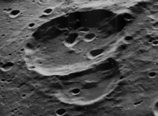
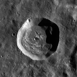
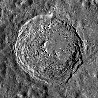
An impact crater is a depression in the surface of a planet, moon, or other solid body in the Solar System or elsewhere, formed by the hypervelocity impact of a smaller body. In contrast to volcanic craters, which result from explosion or internal collapse, impact craters typically have raised rims and floors that are lower in elevation than the surrounding terrain. Lunar impact craters range from microscopic craters on lunar rocks returned by the Apollo Program and small, simple, bowl-shaped depressions in the lunar regolith to large, complex, multi-ringed impact basins. Meteor Crater is a well-known example of a small impact crater on Earth.
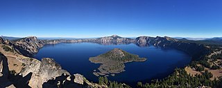
Crater Lake National Park is an American national park located in southern Oregon. Established in 1902, Crater Lake is the fifth-oldest national park in the United States and the only national park in Oregon. The park encompasses the caldera of Crater Lake, a remnant of Mount Mazama, a destroyed volcano, and the surrounding hills and forests.

The Fra Mauro formation is a formation on the near side of Earth's Moon that served as the landing site for the American Apollo 14 mission in 1971. It is named after the 80-kilometer-diameter crater Fra Mauro, located within it. The formation, as well as Fra Mauro crater, take their names from a 15th-century Italian monk and mapmaker of the same name. Apollo 13 was originally scheduled to land in the Fra Mauro highlands, but was unable due to an in-flight technical failure.

Volcanic cones are among the simplest volcanic landforms. They are built by ejecta from a volcanic vent, piling up around the vent in the shape of a cone with a central crater. Volcanic cones are of different types, depending upon the nature and size of the fragments ejected during the eruption. Types of volcanic cones include stratocones, spatter cones, tuff cones, and cinder cones.

Mount Mazama is a complex volcano in the state of Oregon, United States, in a segment of the Cascade Volcanic Arc and Cascade Range. Most of the mountain collapsed following a major eruption approximately 7,700 years ago. The volcano is in Klamath County, in the southern Cascades, 60 miles (97 km) north of the Oregon–California border. Its collapse formed a caldera that holds Crater Lake. The mountain is in Crater Lake National Park. Mount Mazama originally had an elevation of 12,000 feet (3,700 m), but following its climactic eruption this was reduced to 8,157 feet (2,486 m). Crater Lake is 1,943 feet (592 m) deep, the deepest freshwater body in the US and the second deepest in North America after Great Slave Lake in Canada.

Neith crater is a crater on Jupiter's moon Ganymede, the largest moon in the solar system.

Cepheus is a lunar impact crater that is located in the northeastern part of the Moon, within one crater diameter of the larger crater Franklin to the southeast. To the north-north-east is the flooded crater Oersted. The proximity of this formation to the lunar limb means it appears oblong when viewed from the Earth due to foreshortening.

Ellison is a lunar impact crater that lies on the far side of the Moon from the Earth. It is located just beyond the northwest limb of the Moon, to the southwest of the large walled plain Poczobutt. Due west of Ellison is the crater Coulomb.

Blazhko is a lunar impact crater that is located in the northern hemisphere on the far side of the Moon. It lies to the northwest of the crater Joule, and to the south of Gadomski. The fresh, bright crater Wargo is to the south.
Chaffee is a lunar impact crater that is located in the southern hemisphere on the far side of the Moon. It lies within the huge walled plain Apollo, and is one of several craters in that formation named for astronauts and people associated with the Apollo program. This basin is a double-ringed formation, and the crater Chaffee is situated across the southwest part of the inner ring. The ridge from this ring extends northward from the northern rim of Chaffee.
Chant is a lunar impact crater that is located on the far side of the Moon, behind the southwest limb as seen from the Earth. It lies within the southwestern part of the blanket of ejecta surrounding the Mare Orientale, beyond the Montes Cordillera mountain ring. To the west-northwest is the large walled plain Blackett. Southward is the crater Mendel.

Drebbel is a small lunar impact crater named after Cornelius Drebbel that is located to the northeast of the large walled plain Schickard, in the southwestern part of the Moon. Further to the northeast is the Lacus Excellentiae and the small crater Clausius.

Graff is a small lunar impact crater that lies along the southwestern limb of the Moon. It is located to the west of the Vallis Bouvard depression in the southern part of the ejecta blanket that surrounds the Mare Orientale impact basin. To the south-southwest is the smaller crater Catalán.
Vavilov is a prominent impact crater that is located to the west of the walled plain Hertzsprung. It is located on the far side of the Moon and cannot be viewed directly from the Earth. About a crater diameter to the northwest is the smaller Chaucer, and farther to the southwest is Sechenov.

A cinder cone is a steep conical hill of loose pyroclastic fragments, such as volcanic clinkers, volcanic ash, or scoria that has been built around a volcanic vent. The pyroclastic fragments are formed by explosive eruptions or lava fountains from a single, typically cylindrical, vent. As the gas-charged lava is blown violently into the air, it breaks into small fragments that solidify and fall as either cinders, clinkers, or scoria around the vent to form a cone that often is symmetrical; with slopes between 30 and 40°; and a nearly circular ground plan. Most cinder cones have a bowl-shaped crater at the summit.

A pit crater is a depression formed by a sinking or collapse of the surface lying above a void or empty chamber, rather than by the eruption of a volcano or lava vent. Pit craters are found on Mercury, Venus, Earth, Mars, and the Moon. Pit craters are often found in a series of aligned or offset chains and in these cases, the features is called a pit crater chain. Pit crater chains are distinguished from catenae or crater chains by their origin. When adjoining walls between pits in a pit crater chain collapse, they become troughs. In these cases, the craters may merge into a linear alignment and are commonly found along extensional structures such as fractures, fissures and graben. Pit craters usually lack an elevated rim as well as the ejecta deposits and lava flows that are associated with impact craters. Pit craters are characterized by vertical walls that are often full of fissures and vents. They usually have nearly circular openings.

Gertrude is the largest known crater on Uranus's moon Titania. It is about 326 km across, 1/5 of Titania's diameter. It is named after the mother of Hamlet in William Shakespeare's play Hamlet. Features on Titania are named after female Shakespearean characters.

Complex craters are a type of large impact crater morphology.

The Charity Shoal crater is a 1.2–1.4 kilometers (0.75–0.87 mi) in diameter circular feature that lies submerged beneath the northeast end of Lake Ontario about 12 kilometers (7.5 mi) southwest of Wolfe Island, and 25 kilometers (16 mi) south of Kingston, Ontario at about latitude 44° 02′ N and longitude 76° 29′ W. It is hypothesized to be a Middle Ordovician impact crater.