
The South Saskatchewan River is a major river in the Canadian provinces of Alberta and Saskatchewan. The river begins at the confluence of the Bow and Oldman Rivers in southern Alberta and ends at the Saskatchewan River Forks in central Saskatchewan. The Saskatchewan River Forks is the confluence of the South and North Saskatchewan Rivers and is the beginning of the Saskatchewan River.

The Bow River is a river in Alberta, Canada. It begins within the Canadian Rocky Mountains and winds through the Alberta foothills onto the prairies, where it meets the Oldman River, the two then forming the South Saskatchewan River. These waters ultimately flow through the Nelson River into Hudson Bay. The Bow River runs through the city of Calgary, taking in the Elbow River at the historic site of Fort Calgary near downtown. The Bow River pathway, developed along the river's banks, is considered a part of Calgary's self-image.
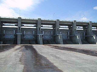
The Gardiner Dam on the South Saskatchewan River in Saskatchewan is the third largest embankment dam in Canada and one of the largest embankment dams in the world. Construction on Gardiner Dam and the smaller Qu'Appelle River Dam was started in 1959 and completed in 1967, creating Lake Diefenbaker upstream and diverting a considerable portion of the South Saskatchewan's flow into the Qu'Appelle River. The dam rises 64 metres (209 feet) in height, is almost 5 km (3.1 mi) long and has a width of 1.5 km (0.93 mi) at its base with a volume of 65,000,000 cubic meters. The dam is owned and operated by the Saskatchewan Water Security Agency.

The Peace River is a 1,923-kilometre-long (1,195 mi) river in Canada that originates in the Rocky Mountains of northern British Columbia and flows to the northeast through northern Alberta. The Peace River joins the Athabasca River in the Peace-Athabasca Delta to form the Slave River, a tributary of the Mackenzie River. The Finlay River, the main headwater of the Peace River, is regarded as the ultimate source of the Mackenzie River. The combined Finlay–Peace–Slave–Mackenzie river system is the 13th longest river system in the world.

Ross Lake is a large reservoir in the North Cascade mountains of northern Washington state, United States, and southwestern British Columbia, Canada. The lake runs approximately north–south, is 23 miles (37 km) long, up to 1.5 miles (2.5 km) wide, and the full reservoir elevation is 1,604 feet above sea level.

The Oldman River is a river in southern Alberta, Canada. It flows roughly west to east from the Rocky Mountains, through the communities of Fort Macleod, Lethbridge, and on to Grassy Lake, where it joins the Bow River to form the South Saskatchewan River, which eventually drains into the Hudson Bay.
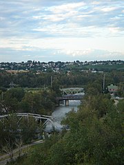
The Elbow River is a river in southern Alberta, Canada. It flows from the Canadian Rockies to the city of Calgary, where it merges into the Bow River.

The Red Deer River is a river in Alberta and a small portion of Saskatchewan, Canada. It is a major tributary of the South Saskatchewan River and is part of the larger Saskatchewan-Nelson system that empties into Hudson Bay.

Division No. 3 is a census division in Alberta, Canada. It is located in the southwest corner of southern Alberta and its largest urban community is the Town of Claresholm.
Brocket is a settlement in Peigan 147, in southern Alberta located on Highway 3 between Pincher Creek and Fort Macleod. It is the main community on the Piikani Nation reserve.

Waterton Lake is a mountain lake in southern Alberta, Canada and northern Montana, United States. The lake is composed of two bodies of water, connected by a shallow channel known locally as the Bosporus. The two parts are referred to as Middle Waterton Lake, and Upper Waterton Lake, the latter of which is divided by the Canada–United States border with Canada containing about two thirds of the lake while the Southern third falls in the United States. The Boundary Commission Trail ends at the lake as the last border marker was placed there on 8 August 1874. The United States Geological Survey gives the geocoordinates of 49°03′00″N113°54′03″W for Upper Waterton Lake. Lower Waterton Lake is north of Middle Waterton Lake and is separated by a channel known as the Dardanelles.

The Brazeau River is a river in western Alberta, Canada. It is a major tributary of the North Saskatchewan River.
McGregor Lake is an elongated reservoir in Southern Alberta. McGregor Lake was created in 1920 by the completion of two dams bracketing water flowing through in Snake Valley. It is situated 100 km (62 mi) southeast of Calgary in the Vulcan County.

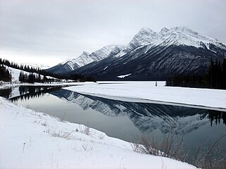
Ghost Lake is a reservoir in Western Alberta, Canada, formed along the Bow River. It is located approximately 45 km (28 mi) west of the city of Calgary and immediately west of Cochrane. It has a water surface of 11.6 km2 (4.5 sq mi) and a drainage basin of 6,460 km2 (2,490 sq mi) The average depth of the lake is 14.5 m (48 ft), and it reaches a maximum of 34 m (112 ft)
Pincher Creek was a provincial electoral district in Alberta, Canada, mandated to return a single member to the Legislative Assembly of Alberta from 1905 to 1940.

Brazeau Reservoir is a large man made reservoir in Alberta, Canada.
Gleniffer Lake also known as Gleniffer Reservoir or originally Lake Gleniffer is an artificial lake in central Alberta, Canada created in 1983 by the construction of the Dickson Dam which impounded the Red Deer River, a major tributary of the South Saskatchewan River which flows into the Saskatchewan River Basin.
Spray Lakes Reservoir is a reservoir in Alberta, Canada. The Spray Lakes were a string of lakes formed along the Spray River, a tributary of the Bow River. With the damming of the river, the lakes were united in the Spray Lakes Reservoir.

Piikani 147, formerly Peigan 147, is an Indian reserve of the Piikani Nation in Alberta. It is located 61 km (38 mi) west of the City of Lethbridge. It has a land area of 426.992 km2 (164.863 sq mi), making it the fourth-largest Indian reserve in Canada, and lies at an elevation of 1,046 m (3,432 ft). The Canada 2011 Census reported a population of 1,217 inhabitants. It is bordered by the Municipal District of Willow Creek No. 26 on its north and east, and by the Municipal District of Pincher Creek No. 9 on its west and south. The nearest outside communities are Fort Macleod and Pincher Creek.
Oldman River Hydroelectric Plant is a run-of-river hydroelectric power station owned by Atco Power (75%) and Piikani Nation (25%). The plant is located on the Oldman River near in Pincher Creek, Alberta, Canada. The plant is primarily used to supply power onto the Alberta grid.