Gmina Dąbie is an urban-rural gmina in Koło County, Greater Poland Voivodeship, in west-central Poland. Its seat is the town of Dąbie, which lies approximately 19 kilometres (12 mi) south-east of Koło and 135 km (84 mi) east of the regional capital Poznań.

Gmina Grzegorzew is a rural gmina in Koło County, Greater Poland Voivodeship, in west-central Poland. Its seat is the village of Grzegorzew, which lies approximately 6 kilometres (4 mi) south-east of Koło and 125 km (78 mi) east of the regional capital Poznań.
Gmina Kłodawa is an urban-rural gmina in Koło County, Greater Poland Voivodeship, in west-central Poland. Its seat is the town of Kłodawa, which lies approximately 21 kilometres (13 mi) east of Koło and 138 km (86 mi) east of the regional capital Poznań.

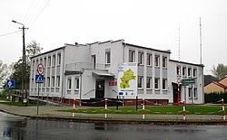
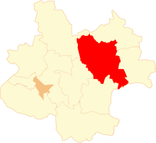
Gmina Olszówka is a rural gmina in Koło County, Greater Poland Voivodeship, in west-central Poland. Its seat is the village of Olszówka, which lies approximately 14 kilometres (9 mi) east of Koło and 133 km (83 mi) east of the regional capital Poznań.

Gmina Przykona is a rural gmina in Turek County, Greater Poland Voivodeship, in west-central Poland. Its seat is the village of Przykona, which lies approximately 9 kilometres (6 mi) south-east of Turek and 125 km (78 mi) east of the regional capital Poznań.

Adamin is a village in the administrative district of Gmina Olszówka, within Koło County, Greater Poland Voivodeship, in west-central Poland. It lies approximately 16 kilometres (10 mi) east of Koło and 135 km (84 mi) east of the regional capital Poznań.
Drzewce is a village in the administrative district of Gmina Olszówka, within Koło County, Greater Poland Voivodeship, in west-central Poland.
Głębokie is a village in the administrative district of Gmina Olszówka, within Koło County, Greater Poland Voivodeship, in west-central Poland.
Krzewata is a village in the administrative district of Gmina Olszówka, within Koło County, Greater Poland Voivodeship, in west-central Poland.
Łubianka is a village in the administrative district of Gmina Olszówka, within Koło County, Greater Poland Voivodeship, in west-central Poland. It lies approximately 4 kilometres (2 mi) south of Olszówka, 16 km (10 mi) east of Koło, and 135 km (84 mi) east of the regional capital Poznań.
Mniewo is a village in the administrative district of Gmina Olszówka, within Koło County, Greater Poland Voivodeship, in west-central Poland.
Nowa Wioska is a village in the administrative district of Gmina Olszówka, within Koło County, Greater Poland Voivodeship, in west-central Poland.
Ostrów is a village in the administrative district of Gmina Olszówka, within Koło County, Greater Poland Voivodeship, in west-central Poland. It lies approximately 14 kilometres (9 mi) south-east of Koło and 133 km (83 mi) east of the regional capital Poznań.
Ponętów Górny Drugi is a village in the administrative district of Gmina Olszówka, within Koło County, Greater Poland Voivodeship, in west-central Poland. It lies approximately 13 kilometres (8 mi) east of Koło and 132 km (82 mi) east of the regional capital Poznań.
Ponętów Górny Pierwszy is a village in the administrative district of Gmina Olszówka, within Koło County, Greater Poland Voivodeship, in west-central Poland. It lies approximately 13 kilometres (8 mi) east of Koło and 132 km (82 mi) east of the regional capital Poznań.
Przybyszew is a village in the administrative district of Gmina Olszówka, within Koło County, Greater Poland Voivodeship, in west-central Poland. It lies approximately 6 kilometres (4 mi) east of Olszówka, 20 km (12 mi) east of Koło, and 138 km (86 mi) east of the regional capital Poznań.
Tomaszew is a village in the administrative district of Gmina Olszówka, within Koło County, Greater Poland Voivodeship, in west-central Poland.

Umień is a village in the administrative district of Gmina Olszówka, within Koło County, Greater Poland Voivodeship, in west-central Poland. It lies approximately 15 kilometres (9 mi) east of Koło and 134 km (83 mi) east of the regional capital Poznań.
Zawadka is a village in the administrative district of Gmina Olszówka, within Koło County, Greater Poland Voivodeship, in west-central Poland.
Złota is a village in the administrative district of Gmina Olszówka, within Koło County, Greater Poland Voivodeship, in west-central Poland. It lies approximately 4 kilometres (2 mi) north of Olszówka, 14 km (9 mi) east of Koło, and 133 km (83 mi) east of the regional capital Poznań.