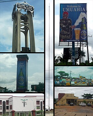
Umuahia is the capital city of Abia State in southeastern Nigeria. Umuahia is located along the rail road that lies between Port Harcourt to its south,and Enugu city to its north. Umuahia has a population of 359,230 according to the 2006 Nigerian census. Umuahia is indigenously Igbo.
Asaba is the capital of Delta State, Nigeria. A rapidly growing city, it is located at the western bank of the Niger River, in the Oshimili South Local Government Area. Asaba had a population of 149,603 as at the 2006 census, and a fast growing metropolitan population of over half a million people.

Enugu State is a state in the South-East geopolitical zone of Nigeria, bordered to the north by the states of Benue and Kogi, Ebonyi State to the east and southeast, Abia State to the south, and Anambra State to the west. The state takes its name from its capital and largest city, Enugu. The city acquired township status in 1917 and was called Enugwu-Ngwo. Due to the rapid expansion towards areas owned by other indigenous communities, it was renamed Enugu in 1928.
Awka North is a Local Government Area in Anambra State, south-central Nigeria. Towns that make up the local government are Awba Ofemili, Ugbenu, Ugbene, Ebenebe, Achalla, Urum, Amansea, Amanuke, Isu Aniocha, Mgbakwu,.

Anaocha is a Local Government Area in Anambra State, south-eastern Nigeria. Towns that make up the local government are Aguluzigbo, Agulu, Neni, Ichida, Adazi-Ani, Adazi-Enu, Adazi-Nnukwu, Akwaeze, Nri, Obeledu.
Dunukofia is a Local Government Area in Anambra State, South-East Nigeria. Towns that make up the local government are Ukpo, the headquarters; Ifitedunu, Dunukofia Umunnachi, Umudioka, Ukwulu and Nawgu. It shares boundaries with Awka North, Idemili North, Njikoka and Oyi Local Governments.
Ekwusigo is a Local Government Area in Anambra State, south-central Nigeria. Towns that make up the local government are Ozubulu, Oraifite, Ichi and Ihembosi.
Idemili South is a Local Government Area in Anambra State, South-East Nigeria. The headquarters is Ojoto secretariate which was built by Hon Sylva. G. Abasilim the first elected council chairman and was commissioned by Prof Audu Ogbe when he was the People's democratic party National chairman and this was done under Gov. Mbadinuju Chimaroke and the estimated number of people is 159,631. The towns that make up the local government are Akwu-Ukwu, Alor, Awka-Etiti, Ojoto, Nnokwa, Oba and Nnobi.
Idemili North is a Local Government Area in Anambra State, South-Central Nigeria. Towns that make up the local government are: Abacha, Abatete, Eziowelle, Ideani, Nkpor, Obosi, Ogidi, Oraukwu, Uke, Umuoji. Its headquarters is located in Ogidi.
Onitsha North is a Local Government Area in Anambra State, South-East Nigeria. The headquarters is in GRA, Onitsha. Onitsha is the only town in Onitsha North and Onitsha South LGA. Onitsha North has a boundary by Idemili North and Oyi local government areas to the East, Anambra East local government area to the North, Onitsha South local government area by the South and Delta State by the West. But then, it has various localities that are residential areas for the population living in the local government area. These include Omagba Layout Phases 1 & 2, Inland Town, GRA, Federal Housing Estate Trans Nkisi GRA, Akpaka, Odoakpu, Ose, Omagba, etc. Onitsha North also has various primary and secondary schools owned by the government, individuals, and missions. It is also known as the city where the biggest market in West Africa is situated. However, Onitsha North has experienced several degrees of conflicts and riots. It was also affected by floods.
Orumba North is a Local Government Area in Anambra State, East-central Nigeria.

Oyi is a Local Government Area in Anambra State, Nigeria. It is home to the Oyi people. The towns that make up the local government are Nkwelle-Ezunaka, Awkuzu, Ogbunike, Umuneba, Umunya and Nteje.
Ankpa is a Local Government Area in Kogi State, Nigeria. Its headquarters are in the town of Ankpa on the A233 highway in the west of the area at7°22′14″N7°37′31″E.

Akko is a local government area of Gombe, Gombe State, Nigeria. Its headquarters is in Kumo town on the A345 highway south of the state capital Gombe, about 40 km away. Kumo (headquarter) is a cosmopolitan communities of more than 30 differents tribes, ranging from the dominant Fulani tribe to Tangale, Tera, Hausa and other minorities.
Uga is a town in Aguata Local Government Area of Anambra State, Nigeria. It is 13 km South East of Igbo-Ukwu, 12 km South of Ekwulobia, and 45 km South of Awka, the Anambra State Capital. It has four (4) communities namely : Umueze, Oka, Umuoru and Awarasi. It has recognised landmarks and tourist attractions such as the "Obizi Uga", a natural spring and a spectacular scenery which was the site of an ancient tale in the Uga oral tradition. Uga is the site of an annual traditional celebration known as the "OBUOFOR" festival held every 26 December. Uga has one of the largest markets in the Aguata local government area known as "ORIE" which supports the economic activities of the local community and other surrounding towns.

Inyi is a town in Enugu State, Nigeria. The name "Inyi" refers to a metaphor, which is an essential component in the creation of proverbs. It is the Igbo name for the red water tree. Due to historical events connecting the tree and the town's founder, he was given the name, which subsequently became the town's name.
Anaku is one of the administrative divisions of Anambra State, South-Eastern Nigeria. The town lies 6°15' North of the Equator and 6°44' East of the Greenwich Meridian. It is bordered by "Omabala," the native name of the Anambra River, which is a tributary of the River Niger (North), Aguleri, Ezu River (South), Omor and Umuerum communities (East).
Ebenebe is a town in the Awka North Local Government Area of Anambra State, Nigeria. The town has an estimated population of 45,897 according to the 2006 Nigerian Census. Ebenebe is made up of eight villages, each of which contain hamlets.
Umulokpa is a town in Enugu State, Nigeria. It serves as the headquarters of Uzo-Uwani Local Government Area (L.G.A) in Enugu State, and has a population of over 150,000.
Amaetiti is a town in Orumba North Local Government Area of Anambra State, located in the Southeast geopolitical zone of Nigeria.
