A geographic information system (GIS) is a system designed to capture, store, manipulate, analyze, manage, and present spatial or geographic data. GIS applications are tools that allow users to create interactive queries, analyze spatial information, edit data in maps, and present the results of all these operations. GIS sometimes refers to geographic information science (GIScience), the science underlying geographic concepts, applications, and systems.
Development communication refers to the use of communication to facilitate social development. Development communication engages stakeholders and policy makers, establishes conducive environments, assesses risks and opportunities and promotes information exchanges to create positive social change via sustainable development. Development communication techniques include information dissemination and education, behavior change, social marketing, social mobilization, media advocacy, communication for social change, and community participation.
Participatory design is an approach to design attempting to actively involve all stakeholders in the design process to help ensure the result meets their needs and is usable. Participatory design is an approach which is focused on processes and procedures of design and is not a design style. The term is used in a variety of fields e.g. software design, urban design, architecture, landscape architecture, product design, sustainability, graphic design, planning, and even medicine as a way of creating environments that are more responsive and appropriate to their inhabitants' and users' cultural, emotional, spiritual and practical needs. It is one approach to placemaking.
The United Nations defines community development as "a process where community members come together to take collective action and generate solutions to common problems." It is a broad term given to the practices of civic leaders, activists, involved citizens and professionals to improve various aspects of communities, typically aiming to build stronger and more resilient local communities.
Geoinformatics is the science and the technology which develops and uses information science infrastructure to address the problems of geography, cartography, geosciences and related branches of science and engineering.
Agricultural extension is the application of scientific research and new knowledge to agricultural practices through farmer education. The field of 'extension' now encompasses a wider range of communication and learning activities organized for rural people by educators from different disciplines, including agriculture, agricultural marketing, health, and business studies.

Public participation is a political principle or practice, and may also be recognised as a right. The terms public participation, often called P2 by practitioners, is sometimes used interchangeably with the concept or practice of stakeholder engagement and/or popular participation.

Participatory rural appraisal (PRA) is an approach used by non-governmental organizations (NGOs) and other agencies involved in international development. The approach aims to incorporate the knowledge and opinions of rural people in the planning and management of development projects and programmes.
Participatory GIS (PGIS) is a participatory approach to spatial planning and spatial information and communications management.
Participatory development communication is the use of mass media and traditional, inter-personal means of communication that empowers communities to visualise aspirations and discover solutions to their development problems and issues.
Participatory planning is an urban planning paradigm that emphasizes involving the entire community in the strategic and management processes of urban planning; or, community-level planning processes, urban or rural. It is often considered as part of community development. Participatory planning aims to harmonize views among all of its participants as well as prevent conflict between opposing parties. In addition, marginalized groups have an opportunity to participate in the planning process.

Collaborative mapping is the aggregation of Web mapping and user-generated content, from a group of individuals or entities, and can take several distinct forms. With the growth of technology for storing and sharing maps, collaborative maps have become competitors to commercial services, in the case of OpenStreetMap, or components of them, as in Google Map Maker and Yandex.Map editor.
Traditional knowledge geographic information systems (GIS) are the data, techniques, and technologies designed to document and utilize local knowledges in communities around the world. Traditional knowledge is information that encompasses the experiences of a particular culture or society. Traditional knowledge GIS are more valuable than ordinary cognitive maps in that they express environmental and spiritual relationships among real and conceptual entities. They comprise a formidable toolset for use in cultural preservation, land rights disputes, natural resource management, and economic development.

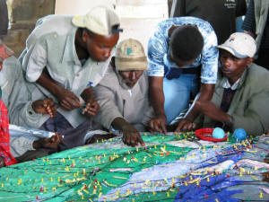
Participatory 3D modelling (P3DM) is a community-based mapping method which integrates local spatial knowledge with data on elevation of the land and depth of the sea to produce stand-alone, scaled and geo-referenced relief models. Essentially based on local spatial knowledge, land use and cover, and other features are depicted by informants on the model by the use of pushpins (points), yarns (lines) and paints (polygons). On completion, a scaled and geo-referenced grid is applied to facilitate data extraction or importation. Data depicted on the model are extracted, digitised and plotted. On completion of the exercise the model remains with the community.
A public participation geographic information system (PPGIS) is meant to bring the academic practices of GIS and mapping to the local level in order to promote knowledge production by local and non-governmental groups. The idea behind PPGIS is empowerment and inclusion of marginalized populations, who have little voice in the public arena, through geographic technology education and participation. PPGIS uses and produces digital maps, satellite imagery, sketch maps, and many other spatial and visual tools, to change geographic involvement and awareness on a local level. The term was coined in 1996 at the meetings of the National Center for Geographic Information and Analysis (NCGIA).

Participatory development (PD) seeks to engage local populations in development projects. Participatory development has taken a variety of forms since it emerged in the 1970s, when it was introduced as an important part of the "basic needs approach" to development. Most manifestations of public participation in development seek "to give the poor a part in initiatives designed for their benefit" in the hopes that development projects will be more sustainable and successful if local populations are engaged in the development process. PD has become an increasingly accepted method of development practice and is employed by a variety of organizations. It is often presented as an alternative to mainstream "top-down" development. There is some question about the proper definition of PD as it varies depending on the perspective applied. Two perspectives that can define PD are the "Social Movement Perspective" and the "Institutional Perspective":
Geodesign is a set of concepts and methods to get all stakeholders and different professions involved in order to collaboratively design and realize the optimal solution for spatial challenges in the built and natural environments, utilizing all available techniques and data in an integrated process. Originally, geodesign was mainly applied during the design & planning phase. "Geodesign is a design and planning method which tightly couples the creation of design proposals with impact simulations informed by geographic contexts." Now, it is also used during realization and maintenance phases and to facilitate re-use of for example buildings or industrial areas. Geodesign includes project conceptualization, analysis, design specification, stakeholder participation and collaboration, design creation, simulation, and evaluation.
Esri Canada is the Canadian provider of enterprise geographic information system (GIS) solutions from Esri. GIS allows multiple layers of information to be displayed on a single map. Esri Canada’s solutions are based on ArcGIS technology. The company also distributes vertical-focused solutions from technology partners such as Schneider Electric. A third of its offerings are professional services.

Geographic information system (GIS) is a commonly used tool for environmental management, modelling and planning. As simply defined by Michael Goodchild, GIS is as ‘a computer system for handling geographic information in a digital form’. In recent years it has played an integral role in participatory, collaborative and open data philosophies. Social and technological evolutions have elevated ‘digital’ and ‘environmental’ agendas to the forefront of public policy, the global media and the private sector.
The Urban and Regional Information Systems Association (URISA) is a non-profit association of professionals using geographic information systems (GIS) and other information technologies to solve challenges at all levels of government. URISA promotes the effective and ethical use of spatial information and technology for the understanding and management of urban and regional systems.


