
Ruurlo is a village and former municipality in the province of Gelderland in the eastern part of the Netherlands.

Steenderen is a former municipality and a village in the eastern Netherlands. It has been part of the new municipality of Bronckhorst since 2005.

Vorden is a former municipality and a town in the eastern Netherlands, about 10 kilometres south-east of Zutphen. On 1 January 2005 the municipality merged with Hummelo en Keppel, Steenderen, Hengelo en Zelhem, to form the new municipality Bronckhorst.
Heemskerk is a municipality and a town in the Netherlands, in the province of North Holland. It is located in the Kennemerland region.

Bruchterveld is a village near the town of Hardenberg, Overijssel, the Netherlands. There is a village house and a football association. It has three churches: Dutch reformed, Dutch reformed freed and Reformed.

Diepenheim is a small city in the Dutch province of Overijssel. It is located in the municipality of Hof van Twente, about 5 km southwest of Goor. Diepenheim was a separate municipality until 2001, when it became a part of Hof van Twente.

Norg is a village in the northeastern Netherlands. It is located in the municipality of Noordenveld, Drenthe. It used to be an independent municipality until 1998. Norg is home to two windmills.

Emst is a village in the municipality of Epe in the province of Gelderland in the Netherlands. It is the birthplace of former footballer Marc Overmars. Emst is located in the forest area of Veluwe.

Eck en Wiel is a village in the Dutch province of Gelderland. It is a part of the municipality of Buren, and lies about 9 km southwest of Veenendaal.
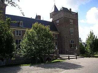
Zoelen is a village in the Dutch province of Gelderland. It is a part of the municipality of Buren, and lies about 3 km north of Tiel. Castle Zoelen is located near the village.

Ewijk is a village in the Dutch province of Gelderland. It is a part of the municipality of Beuningen, and lies about 9 km west of Nijmegen. The river Waal runs in the north.

Winssen is a village in the Dutch province of Gelderland. It is the smallest village of the municipality of Beuningen, and lies about 8 km north of Wijchen. It lies south of the river Waal

IJsselmuiden is a town in the Dutch province of Overijssel. It is located in the municipality of Kampen, northeast of that city across the river IJssel.

Beek is a village in the Dutch province of Gelderland. It is located in the municipality of Berg en Dal, about 5 km east of Nijmegen. It was sometimes referred to as "Beek " or "Beek-Ubbergen" because there are many villages called Beek.

Hoenderloo is a Dutch village located south west of the city of Apeldoorn. Most of the village is part of the municipality of Apeldoorn, but a small part belongs to the municipality of Ede, among which the hamlet Hoog Baarlo.

Pujols is a commune in the Lot-et-Garonne department in south-western France.

Hoog Soeren is a village in the municipality of Apeldoorn, in the province of Gelderland in the Netherlands. Since 1863, it is a crown land.
Erlecom is a hamlet in the Dutch municipality of Berg en Dal, in the province of Gelderland.

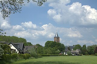
Persingen is a village situated in the municipality of Berg en Dal in the province of Gelderland. In 2021, Persingen had 105 inhabitants. The village claims to be the smallest village of the Netherlands for tourist reasons, however there are many more contestants who are much smaller; the former island of Schokland and the former squatter village of Ruigoord have the best credentials.

Westernieland is a village in the Dutch province of Groningen. It is part of the municipality of Het Hogeland. The village is located near the Wadden Sea.


