Related Research Articles

Noonday Creek is a 20.2-mile-long (32.5 km) stream in Cobb and Cherokee counties in the U.S. state of Georgia. The stream begins near Kennesaw Mountain and ends at Lake Allatoona.

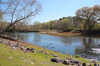
The Little River is a 29.3-mile-long (47.2 km) tributary of the Etowah River in the U.S. state of Georgia in the United States.

The Cartecay River is a 19.1-mile-long (30.7 km) river that runs into Ellijay, Georgia, in Gilmer County. It is the site of a class II whitewater run.
Salacoa Creek is a stream in Bartow County, in northwestern Georgia, United States, that is a tributary of the Coosawattee River. Its own tributaries include the Pine Log Creek.

Connesena Creek is a stream in Bartow County, in the U.S. state of Georgia. It is a tributary to the Etowah River.

Pettit Creek is a stream in Bartow County, Georgia.
Pumpkinvine Creek is a stream in the U.S. state of Georgia. It is a tributary of the Etowah River.
Stamp Creek is a stream in the U.S. state of Georgia. It empties into Lake Allatoona.
Talking Rock Creek is a stream in the northwestern Georgia, United States, that is a tributary of the Coosawattee River.
Turniptown Creek is a stream in the U.S. state of Georgia. It is a tributary to the Ellijay River.

Baldridge Creek is a stream in Forsyth County in the U.S. state of Georgia. It empties into Lake Lanier. The stream headwaters arise northeast of Coal Mountain and the stream flows southeast paralleling US 19. Previous to the creation of the lake the stream entered the Chattahoochee River at the Forsyth-Hall county line at 34°10′42″N84°04′17″W.
Amicalola Creek is a stream in the U.S. state of Georgia. It is a tributary to the Etowah River. Amicalola Falls, a tall waterfall on its course, lends its name to Amicalola Falls State Park.
Canton Creek is a stream in the U.S. state of Georgia. It is a tributary to the Etowah River.
Cooper Creek is a stream in the U.S. state of Georgia. It is a tributary to the Toccoa River.
Crane Eater Creek is a stream in Gordon County, Georgia, United States, that is a tributary of the Coosawattee River.
Drowning Bear Creek is a stream in the U.S. state of Georgia. It is a tributary to the Conasauga River.
Level Creek is a stream in Gwinnett County in the U.S. state of Georgia. It is a tributary to the Chattahoochee River.
Mountaintown Creek is a stream in Gilmer County, Georgia, United States, that is a tributary of the Coosawattee River.
Tickanetley Creek is a stream in the U.S. state of Georgia. It is a tributary to the Cartecay River.
Young Deer Creek is a stream in Forsyth County in the U.S. state of Georgia. It is a tributary to the Chattahoochee River.
References
- ↑ U.S. Geological Survey Geographic Names Information System: Oothkalooga Creek
- ↑ Krakow, Kenneth K. (1975). Georgia Place-Names: Their History and Origins (PDF). Macon, GA: Winship Press. p. 167. ISBN 0-915430-00-2.
- ↑ "Bartow County". Calhoun Times. September 1, 2004. p. 23. Retrieved 24 April 2015.
34°24′33″N84°56′46″W / 34.40912°N 84.9462°W