OpenCRG

Last updated

Developer(s) Daimler AG
VIRES GmbH
Initial release2009 (2009)
Stable release
1.0.6 / 9 April 2014;9 years ago (2014-04-09)
Preview release
1.1.0 RC1 / 31 July 2015;8 years ago (2015-07-31)
Size 13 MB
Type Scientific software
License Apache License, version 2.0
Website opencrg.org

OpenCRG is a complete free and open-source project for the creation, modification and evaluation of road surfaces, and an open file format specification CRG (curved regular grid). Its objective is to standardize a detailed road surface description and it may be used for applications like tire-, vibration- or driving-simulation.

Contents

The initial release of OpenCRG was a beta version 0.3 in early 2009; as of August 2015, the current stable release of the OpenCRG C-API and MATLAB tool suite is version 1.0.6. [1]

Overview

OpenCRG is a standardized efficient 3D road data representation defined in base plane by its direction (heading, yaw angle). It is optionally complemented by hilliness (slope, inclination, grade, pitch angle) and cross slope (super-elevation, banking, cant, camber, roll angle). Compact storage and sufficient accuracy, even for long tracks are the objectives for the open file format specification CRG.

A C-API as well as a MATLAB API are provided for the creation, evaluation or modification of OpenCRG files. Both APIs include basic operations like transforming between intrinsic to global coordinates. The MATLAB tool suite provides powerful modification or creation tools and allows to visualize the 3D road data representation.

OpenCRG was initiated by Daimler and is currently driven by VIRES Simulationstechnologie GmbH, the research group AK 6.1.3 'Tire Models for Vehicle Dynamics, Ride Comfort and Uneven Roads' and the OpenCRG community. The associated website maintained by VIRES GmbH is the main portal for information about OpenCRG including latest news concerning the data format, free and commercial tool-sets, test data etc..

With OpenCRG real road surfaces (e.g. by measurement) have also become available to "classic" simulation applications using a macroscopic description of road networks. The gap between the logical road description and the microscopic description of road surfaces (i.e. OpenCRG) is closed by the open file format OpenDRIVE. An implementation of OpenCRG into the OpenDRIVE file format specification has already been established in January 2008. [2]

History

The predecessor of OpenCRG is a format called CRG (curved regular grid) which has been used internally for several years by Daimler AG. [3] An entire suite of MATLAB and FORTRAN tools had been developed for the handling, evaluation and generation of CRG data.

The early phase of the OpenCRG initiative is funded by a series of German automotive OEMs. Representatives of Audi AG Ingolstadt, BMW AG München, Daimler AG Sindelfingen, Porsche AG Weissach and Volkswagen AG Wolfsburg define the objectives of OpenCRG. [4]

Since 2008, Daimler AG develops and refines OpenCRG in collaboration with VIRES GmbH, a simulation technology company.

Features

Clear-text headers

OpenCRG provides various ASCII/binary file formats with clear-text headers. The header contains road parameters for the reference line and the overall configuration of the longitudinal sections, a data definition to define the data format (ASCII/binary) and the sequence of data which is to be expected in the trailing data block as well as modifier and option parameters. Furthermore, it may contain references to other files (typically containing the actual data) to handle different parameters for the same data set.

Arbitrary scalar data

OpenCRG handles any arbitrary scalar data versus a reference grid. These are typically elevation data or friction coefficients. By this, different applications like tire- or vibration simulations take advantage of the open surface descriptions format OpenCRG.

C-API

OpenCRG provides an open source C-API for data handling and evaluation. Based on predecessor CRG-FORTRAN routines (Daimler AG), the enhanced C-API allows easy integration of OpenCRG functionality into third party applications. The major focus is the fast conversion from inertial to global coordinate space of OpenCRG data.

MATLAB API

OpenCRG provides a wide range open source MATLAB tool suite. Additional functionality to the predecessor CRG-MATLAB routines (Daimler AG) for the modification, creation and visualization of OpenCRG files is provided. The focus of the MATLAB tool suite is mainly the modification and visualization of OpenCRG data.

World geodetic system

Real world OpenCRG data files may be generated by several laser scans along a road. [5] World geodetic system coordinates (WGS84), as used by GPS and e.g. Google Maps may be attached to OpenCRG header informations. This allows to track and visualize the road description. The MATLAB API provides an interface to visualize the location of OpenCRG roads on Google Maps.

Sample data

Getting started with OpenCRG is facilitated by a growing library of sample data. A set of test and demo OpenCRG files as well as a detailed documentation are included. Simple examples explain the usage of OpenCRG.

Fields of application

Version history

Project nameVersionRelease dateStatus
OpenCRG
(beta)
C-API 0.3beta10 February 2009
C-API 0.4beta26 May 2009
C-API 0.6beta20 August 2009
tools-suite 0.7beta12 November 2009
OpenCRGtools-suite 0.817 December 2009
tools-suite 1.015 April 2010
tools-suite 1.0.14 June 2010
tools-suite 1.0.228 September 2010
tools-suite 1.0.330 June 2011
tools-suite 1.0.48 December 2011
tools-suite 1.0.528 May 2013
tools-suite 1.0.631 July 2013RC 1
tools-suite 1.0.69 April 2014Stable
tools-suite 1.1.031 July 2015RC 1

System requirements

OpenCRG has full support for 32-bit i586 and 64-bit x86-64 PC hardware. Big and little endian encoding of a given processor is detected automatically in the C-API. It is constantly tested in the following environments:

The OpenCRG MATLAB Tool Suite is provided on any system distribution running MATLAB (R14) or higher. [6]

See also

Related Research Articles

In computer engineering, a hardware description language (HDL) is a specialized computer language used to describe the structure and behavior of electronic circuits, and most commonly, digital logic circuits.

A web service (WS) is either:

Flexible Image Transport System (FITS) is an open standard defining a digital file format useful for storage, transmission and processing of data: formatted as multi-dimensional arrays, or tables. FITS is the most commonly used digital file format in astronomy. The FITS standard was designed specifically for astronomical data, and includes provisions such as describing photometric and spatial calibration information, together with image origin metadata.

<span class="mw-page-title-main">Hierarchical Data Format</span> Set of file formats

Hierarchical Data Format (HDF) is a set of file formats designed to store and organize large amounts of data. Originally developed at the U.S. National Center for Supercomputing Applications, it is supported by The HDF Group, a non-profit corporation whose mission is to ensure continued development of HDF5 technologies and the continued accessibility of data stored in HDF.

OPeNDAP is an acronym for "Open-source Project for a Network Data Access Protocol," an endeavor focused on enhancing the retrieval of remote, structured data through a Web-based architecture and a discipline-neutral Data Access Protocol (DAP). Widely used, especially in Earth science, the protocol is layered on HTTP, and its current specification is DAP4, though the previous DAP2 version remains broadly used. Developed and advanced by the non-profit OPeNDAP, Inc., DAP is intended to enable remote, selective data-retrieval as an easily invoked Web service. OPeNDAP, Inc. also develops and maintains zero-cost (reference) implementations of the DAP protocol in both server-side and client-side software.

COLLADA is an interchange file format for interactive 3D applications. It is managed by the nonprofit technology consortium, the Khronos Group, and has been adopted by ISO as a publicly available specification, ISO/PAS 17506.

A GIS software program is a computer program to support the use of a geographic information system, providing the ability to create, store, manage, query, analyze, and visualize geographic data, that is, data representing phenomena for which location is important. The GIS software industry encompasses a broad range of commercial and open-source products that provide some or all of these capabilities within various information technology architectures.

GRIB is a concise data format commonly used in meteorology to store historical and forecast weather data. It is standardized by the World Meteorological Organization's Commission for Basic Systems, known under number GRIB FM 92-IX, described in WMO Manual on Codes No.306. Currently there are three versions of GRIB. Version 0 was used to a limited extent by projects such as TOGA, and is no longer in operational use. The first edition is used operationally worldwide by most meteorological centers, for Numerical Weather Prediction output (NWP). A newer generation has been introduced, known as GRIB second edition, and data is slowly changing over to this format. Some of the second-generation GRIB is used for derived products distributed in the Eumetcast of Meteosat Second Generation. Another example is the NAM model.

JT is an openly-published ISO-standardized 3D CAD data exchange format used for product visualization, collaboration, digital mockups, and other purposes. It was developed by Siemens.

<span class="mw-page-title-main">Tecplot</span>

Tecplot is the name of a family of visualization & analysis software tools developed by American company Tecplot, Inc., which is headquartered in Bellevue, Washington. The firm was formerly operated as Amtec Engineering. In 2016, the firm was acquired by Vela Software, an operating group of Constellation Software, Inc. (TSX:CSU).

PLY is a computer file format known as the Polygon File Format or the Stanford Triangle Format. It was principally designed to store three-dimensional data from 3D scanners. The data storage format supports a relatively simple description of a single object as a list of nominally flat polygons. A variety of properties can be stored, including color and transparency, surface normals, texture coordinates and data confidence values. The format permits one to have different properties for the front and back of a polygon.

Specialized wind energy software applications aid in the development and operation of wind farms.

NetCDF is a set of software libraries and self-describing, machine-independent data formats that support the creation, access, and sharing of array-oriented scientific data. The project homepage is hosted by the Unidata program at the University Corporation for Atmospheric Research (UCAR). They are also the chief source of netCDF software, standards development, updates, etc. The format is an open standard. NetCDF Classic and 64-bit Offset Format are an international standard of the Open Geospatial Consortium.

<span class="mw-page-title-main">OpenDRIVE (specification)</span>

OpenDRIVE is an open format specification to describe a road network's logic. Its objective is to standardize the logical road description between different driving simulators.

The Functional Mock-up Interface defines a standardized interface to be used in computer simulations to develop complex cyber-physical systems.

<span class="mw-page-title-main">INCA (software)</span> Application software published by ETAS

INCA is a measurement, calibration and diagnostic software published by ETAS. With its large installation base in the auto industry, this development software is deployed during all phases of the development of electronic control units (ECUs) and ECU software programs for measuring, calibration, diagnostics and programming.

<span class="mw-page-title-main">Google Fusion Tables</span> Data management web service

Google Fusion Tables was a web service provided by Google for data management. Fusion tables was used for gathering, visualising and sharing data tables. Data are stored in multiple tables that Internet users can view and download.

ecu.test is a software tool developed by tracetronic GmbH, based in Dresden, Germany, for test and validation of embedded systems. Since the first release of ecu.test in 2003, the software is used as standard tool in the development of automotive ECUs and increasingly in the development of heavy machinery as well as in factory automation. The development of the software started within a research project on systematic testing of control units and laid the foundation for the spin-off of tracetronic GmbH from TU Dresden. ecu.test aims at the specification, implementation, documentation, execution and assessment of test cases. Owing to various test automation methods, the tool ensures an efficient implementation of all necessary activities for the creation, execution and assessment of test cases.

<span class="mw-page-title-main">FEATool Multiphysics</span>

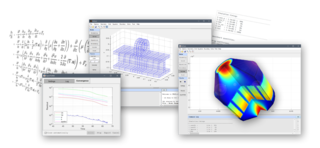
FEATool Multiphysics is a physics, finite element analysis (FEA), and partial differential equation (PDE) simulation toolbox. FEATool Multiphysics features the ability to model fully coupled heat transfer, fluid dynamics, chemical engineering, structural mechanics, fluid-structure interaction (FSI), electromagnetics, as well as user-defined and custom PDE problems in 1D, 2D (axisymmetry), or 3D, all within a graphical user interface (GUI) or optionally as script files. FEATool has been employed and used in academic research, teaching, and industrial engineering simulation contexts.

References

  1. Download OpenCRG , retrieved 5 August 2015
  2. Dupuis, Marius (2 January 2008). "OpenDRIVE Format Specification". OpenDRIVE: VIRES GmbH. Retrieved 4 February 2010.
  3. Rauh, Jochen; Gimmer, Helmut, CRG (curved regular grid) Road Data Format Overview , retrieved 3 February 2010
  4. Rauh, Jochen; Schindler, Heinz; Witte, Lothar; Kersten, Thomas; Zipperer, Wilhelm, OpenCRG A unified approach to represent 3D road data in tyre simulation , retrieved 3 February 2010
  5. Gimmler, H.; Ammon, D.; Rauh, J. (2005), "Road Profiles: Mobile Measurement, Data Processing for Efficient Simulation and Assessment of Road Properties.", VDI-Report No 1912, Düsseldorf(Germany), pp. 335–352{{citation}}: Missing or empty |title= (help)CS1 maint: location missing publisher (link)
  6. Dupuis, Marius; Helmich, Holger, OpenCRG User Manual , retrieved 30 June 2011