Opémisca River

Last updated
Opémisca
Nottaway map.png
Watershed of Nottaway River
Location
Country Canada
Province Quebec
Region Nord-du-Québec
Physical characteristics
SourceForested creek
 - location Eeyou Istchee Baie-James, Nord-du-Québec, Quebec
 - coordinates 49°58′33″N74°45′47″W / 49.97583°N 74.76306°W / 49.97583; -74.76306
 - elevation379 m (1,243 ft)
Mouth Chibougamau River (via Opémisca Lake)
 - location
Eeyou Istchee Baie-James, Nord-du-Québec, Quebec
 - coordinates
49°57′21″N74°54′38″W / 49.95583°N 74.91056°W / 49.95583; -74.91056 Coordinates: 49°57′21″N74°54′38″W / 49.95583°N 74.91056°W / 49.95583; -74.91056
 - elevation
358 m (1,175 ft)
Length39.1 km (24.3 mi) [1]

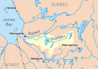
The Opémisca River is a tributary of the Chibougamau River, flowing into the regional County Municipality (RCM) of Eeyou Istchee Baie-James, within the administrative region of Nord-du-Québec, province of Quebec, Canada. The course of the river crosses the townships of Cuvier and Rageot.

Chibougamau River river flowing in municipality of Chibougamau, than Eeyou Istchee Baie-James, in administrative region of Nord-du-Québec, in Quebec, in Canada

The Chibougamau River flows west in the Chibougamau, then Eeyou Istchee James Bay (municipality) in the administrative region of Nord-du-Québec, Quebec, Canada.

Eeyou Istchee James Bay Regional Government is a local municipality in the Jamésie (TE) in administrative region of Nord-du-Québec.

Nord-du-Québec Place in Quebec, Canada

Nord-du-Québec is the largest, but the least populous, of the seventeen administrative regions of Quebec, Canada. With nearly 750,000 square kilometres (290,000 sq mi) of land area, and very extensive lakes and rivers, it covers much of the Labrador Peninsula and about 55% of the total land surface area of Quebec, while containing a little more than 0.5% of the population.

Contents

The hydrographic slope of the Opémisca River is accessible by a forest road on the North shore of Opémisca Lake and connecting South to route 113 which connects Lebel-sur-Quévillon to Chibougamau and passes South of the lake.

Opémisca Lake Lake crossed by the Chibougamau River, in Jamésie, Quebec, Canada

Opémisca Lake is a freshwater body of the Eeyou Istchee Baie-James, in Jamésie, in the administrative region of Nord-du-Québec, in province of Quebec, in Canada. The surface of the lake extends in the cantons of Cuvier, Lévy, Daubrée and Opémisca.

Lebel-sur-Quévillon City in Quebec, Canada

Lebel-sur-Quévillon is a city in the Canadian province of Quebec, located on Route 113 in the Jamésie region. It is located approximately 88 kilometres north of Senneterre and approximately 200 kilometres southwest of Chibougamau. It is surrounded by, but not a part of, the municipality of Baie-James.

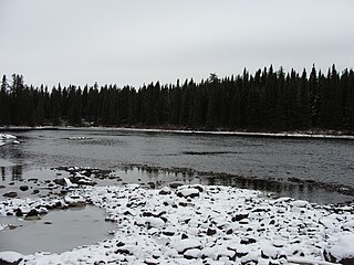
The surface of the Opémisca River is usually frozen from early November to mid-May, however, safe ice circulation is generally from mid-November to mid-April.

Geography

The main hydrographic slopes near the Opémisca River are:
Brock River North tributary of the Brock River (Chibougamau River Slope) in Northern Quebec, Canada

The North Brock River is a tributary of the Brock River, Brock River, flowing into the Eeyou Istchee Baie-James, in Jamésie, in the administrative region of Nord-du-Québec, in the province of Quebec, in the Canada. The course of the river crosses successively the Assinica Wildlife Reserve and the township of La Rochette.

Opataca Lake lake at the head of the Assinica and Broadback rivers, in Nord-du-Québec, Canada

Lake Opataca is a body of water in the Broadback River watershed in the Eeyou Istchee James Bay (municipality) area in the Nord-du-Québec, in the province of Quebec, in Canada. This lake is part of territory of the Assinica Wildlife Sanctuary.

Chibougamau Lake Head Lake of the Chibougamau River, Northern Quebec, Canada

Chibougamau Lake is a freshwater body of the municipality of Chibougamau, in the administrative region of Nord-du-Québec, in province of Quebec, in Canada.

The Opémisca River originates from a forest stream (elevation: 358 metres (1,175 ft)) in the Cuvier township. This source is located at:

Chapais, Quebec City in Quebec, Canada

Chapais is a community in the Canadian province of Quebec, located on Route 113 near Chibougamau in the Jamésie region. It is surrounded by, but not a part of, the municipality of Baie-James. The community was first settled in 1929, when prospector Léo Springer discovered deposits of copper, silver and gold in the area, and was incorporated as a city in 1955. It was named for Thomas Chapais.

Nottaway River tributary of South-East shore James Bay, flowing in munipality of Eeyou Istchee Baie-James, in administrative region of Nord-du-Québec, in Quebec, in Canada

The Nottaway River is a river in Quebec, Canada. The river drains Lake Matagami and travels 225 kilometers (140 mi) north-west before emptying into Rupert Bay at the south end of James Bay. Its drainage basin is 65,800 square kilometers (25,400 sq mi) and has a mean discharge of 1190 m³/s. Its source is the head of the Mégiscane River, which is 776 kilometers (482 mi) from the mouth.

From its source, the Opémisca River flows on 39.1 kilometres (24.3 mi) according to the following segments:

The Opémisca River flows into a small bay on the north shore of Opémisca Lake, at 0.9 kilometres (0.56 mi) west of the mouth of Leclerc Creek and at 0.4 kilometres (0.25 mi) East of the boundary of the Township of Opémisca. From this mouth, the current flows through Opémisca Lake to 8.3 kilometres (5.2 mi) towards the Southwest; this lake is crossed towards the West by the Chibougamau River. From there, the current runs Southwest through the Chibougamau River, tien through Waswanipi River to the East shore of Goéland Lake (Waswanipi River). The latter is crossed to the northwest by the Waswanipi River which is a tributary of Matagami Lake.

Waswanipi River tributary of lake Matagami, flowing in municipality of Eeyou Istchee Baie-James, in administrative region of Nord-du-Québec, in Quebec, in Canada

The Waswanipi River is a tributary of Matagami Lake. The Waswanipi River flows in the Municipality of Eeyou Istchee Baie-James in the administrative region of Nord-du-Québec, in Quebec, Canada.

The mouth of the Opémisca River located at:

Toponymy

Of Cree origin, this hydronym means "the river of sandy shrubs".

The toponym "Opémisca River" was formalized on December 5, 1968, at the Commission de toponymie du Québec, i.e. at the creation of this commission [3]

Related Research Articles

Inconnue River (Maicasagi River) tributary of the Maicasagi River on the Waswanipi River in Northern Quebec, Canada

The Inconnue River is a tributary of the Maicasagi River located in the municipality of Eeyou Istchee Baie-James, in the administrative region of Nord-du-Québec, in the Canadian province of Quebec, in Canada.

Mildred River tributary of Lac La Trève, on the Waswanipi River, in Northern Quebec, Canada

The Mildred River is a tributary of La Trêve Lake, flowing in regional County Municipality (RCM) of Eeyou Istchee James Bay (municipality), in the administrative region of Nord-du-Québec, Canadian province of Quebec, in Canada.

Obatogamau River tributary of the Chibougamau River, Northern Quebec, Canada

The Obatogamau River is a tributary of the Chibougamau River, flowing into the Regional County Municipality (MRC) of Jamésie, in the Nord-du-Québec, in the province of Quebec, in Canada.

Nemenjiche River tributary of Obatomagau Lakes, Northern Quebec, Canada

The Nemenjiche River is a tributary of Obatogamau Lakes, flowing into the Regional County Municipality (RCM) of Eeyou Istchee Baie-James, into the administrative region of Nord-du-Québec, in the province of Quebec, in Canada. The course of the river crosses the townships of Robert, Rohault, Gamache and Dauversière.

Eau Jaune Lake Lake Eeyou Istchee James Bay (Quebec, Canada)

The Eau Jaune Lake is a freshwater body of the Eeyou Istchee Baie-James, in Jamésie, in the administrative region of Nord-du-Québec, province of Quebec, in Canada. This lake extends entirely into the townships of Brongniart and Rasles.

Deux Orignaux River tributary of the Obatogamau River, Northern Quebec, Canada

The Deux Orignaux River is a tributary of the Obatogamau River, flowing into the Regional County Municipality (RCM) of Eeyou Istchee Baie-James, in the administrative region of Nord-du-Québec, in the province of Quebec, in Canada. The course of the river flows entirely into the canton of Dolomieu.

Brock River West tributary of the Brock River (Chibougamau River Slope) in Northern Quebec, Canada

The West Brock River is a tributary of the Brock River, Brock River, flowing into the Eeyou Istchee Baie-James, in Jamésie, in the administrative region of Nord-du-Québec, in the province of Quebec, in the Canada. The course of the river crosses successively the townships of La Rochette, Livillier and La Touche.

Barlow River (Chibougamau River) tributary of the Chibougamau River, Northern Quebec, Canada

The Barlow River is a tributary of the Chibougamau River, flowing into the Regional County Municipality (RCM) of Eeyou Istchee Baie-James, Jamésie, in the administrative region of Nord-du-Québec, in the province of Quebec, in Canada.

Chébistuane River tributary of the Barlow River (Chibougamau River Slope), Nord-du-Québec, Canada

The Chebistuane River is a tributary of the Barlow River, flowing into the Regional County Municipality (RCM) of Eeyou Istchee Baie-James, in Jamésie, in the administrative region of Nord-du-Québec, in the province of Quebec, in Canada.

Mistago River tributary of the Barlow River (Nottaway Slope), Nord-du-Québec, Canada

The Mistago River is a tributary of the Barlow River, flowing into the Regional County Municipality (MRC) of Eeyou Istchee Baie-James, in Jamésie, in the administrative region of Nord-du-Québec, in the province of Quebec, at Canada.

Nepton River (Chibougamau Lake) tributary of Lake Chibougamau, in Northern Quebec, Canada (Nottaway Slope)

The Nepton River is a tributary of Chibougamau Lake, flowing into the Municipality of Eeyou Istchee James Bay, in Jamésie, in the administrative region of Nord-du-Québec, in the province of Quebec, in Canada.

Nepton River North tributary of the Nepton River (slope of Chibougamau Lake and Nottaway), Nord-du-Québec, Canada

The Nepton River North is a tributary of the Nepton River, flowing into the Municipality of Eeyou Istchee Baie-James, in Jamésie, in the administrative region of Nord-du-Québec, in the province of Quebec, to Canada.

Énard River a tributary of Lac Chibougamau (Nottaway Slope), Northern Quebec, Canada

The Énard River is a tributary of Chibougamau Lake, flowing into the municipalities of Eeyou Istchee James Bay and Chibougamau, in Jamésie, in the administrative region of Nord-du-Québec, in the province of Quebec, in Canada.

Oreille River tributary of the Blondeau River (Chibougamau and Nottaway side), Nord-du-Québec, Canada

The Oreille River is a tributary of the Blondeau River, flowing entirely in the town of Chibougamau, in Jamésie, in the administrative region of Nord-du-Québec, in the province of Quebec, in Canada.

Faribault River watercourse in Canada

The Faribault River is a tributary of the east bank of the Chibougamau River flowing into Eeyou Istchee Baie-James (municipality), in Jamésie, in the administrative region from Nord-du-Québec, in Quebec, Canada.

Michwacho Lake lake in Nord-du-Québec, Quebec

Michwacho Lake is a freshwater body crossed by the Chibougamau River, in the southern part of Eeyou Istchee James Bay (municipality), in the administrative region of Nord-du-Québec, in the province of Quebec, in Canada.

References

Map all coordinates using: OpenStreetMap  
Download coordinates as: KML  ·  GPX
  1. "Atlas of Canada". atlas.nrcan.gc.ca. Retrieved 2017-12-19.
  2. Distances from the Department of Natural Resources Canada's Atlas of Canada (published on the Internet).
  3. "Commission de toponymie du Québec – Banque de noms de lieux (Bank of places names) - Toponym: "Opémisca River"". toponymie.gouv.qc.ca. Retrieved 2017-12-19.

See also