Orah, Bileća

Last updated
Orah
Village
Bosnia and Herzegovina location map.svg
Red pog.svg
Orah
Coordinates: 42°48′54″N18°24′58″E / 42.81500°N 18.41611°E / 42.81500; 18.41611
Country Bosnia and Herzegovina
Entity Republika Srpska
Municipality Bileća
Time zone CET (UTC+1)
  Summer (DST) CEST (UTC+2)

Orah (Serbian Cyrillic : Орах) is a village in the municipality of Bileća, Republika Srpska, Bosnia and Herzegovina. [1] It is inhabited by Serbs. The Dobrićevo Monastery was relocated from nearby to this location in 1964.

The Serbian Cyrillic alphabet is an adaptation of the Cyrillic script for Serbo-Croatian, developed in 1818 by Serbian linguist Vuk Karadžić. It is one of the two alphabets used to write standard modern Serbian and Montenegrin, the other being Latin. In Croatian and Bosnian, only the Latin alphabet is used.

Village Small clustered human settlement smaller than a town

A village is a clustered human settlement or community, larger than a hamlet but smaller than a town, with a population ranging from a few hundred to a few thousand. Though villages are often located in rural areas, the term urban village is also applied to certain urban neighborhoods. Villages are normally permanent, with fixed dwellings; however, transient villages can occur. Further, the dwellings of a village are fairly close to one another, not scattered broadly over the landscape, as a dispersed settlement.

Municipalities of Republika Srpska

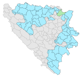
Under the "Law on Territorial Organization and Local Self-Government" adopted in 1994, Republika Srpska was divided into 80 municipalities. After the conclusion of the Dayton Peace Agreement, the law was amended in 1996 to reflect the changes to the entity's borders and now provides for the division of Republika Srpska into 64 municipalities.

Related Research Articles

Centar, Sarajevo Municipality in Bosnia and Herzegovina

Centar is a municipality of the city of Sarajevo, Bosnia and Herzegovina. It is located between the older parts of the city under Stari Grad, and the newer more modern parts of the city under the municipalities Novi Grad and Novo Sarajevo.

Čeljevo Village in Federation of Bosnia and Herzegovina, Bosnia and Herzegovina

Čeljevo is a village in Herzegovina, in Čapljina municipality, Federation of Bosnia and Herzegovina, Bosnia and Herzegovina.

Čepelica Village in Republika Srpska, Bosnia and Herzegovina

Čepelica is a village and the small river in the municipality of Bileća, Republika Srpska, Bosnia and Herzegovina.

Plana, Bileća Village in Republika Srpska, Bosnia and Herzegovina

Plana is a village in the municipality of Bileća, Republika Srpska, Bosnia and Herzegovina.

Plamenice Village in Ključ, Bosnia and Herzegovina

Plamenice is a village in the municipality of Ključ, Bosnia and Herzegovina.

Bobovišta Village in Federation of Bosnia and Herzegovina, Bosnia and Herzegovina

Bobovišta is a village in the municipality of Ravno, Bosnia and Herzegovina. Prior the war in Bosnia and Herzegovina it belonged to Trebinje municipality.

Bogojević Selo Village in Republika Srpska, Bosnia and Herzegovina

Bogojević Selo is a Serbian village in the municipality of Trebinje, Republika Srpska, Bosnia and Herzegovina.

Grab, Trebinje Village in Republika Srpska, Bosnia and Herzegovina

Grab is a village in the municipality of Trebinje, Republika Srpska, Bosnia and Herzegovina. In the census of 1991, there were 135 people, all Serbs.

Vukovići is a village in the municipality of Ravno, Bosnia and Herzegovina. It was formerly part of Trebinje, which is now in the Republika Srpska entity.

Začula Village in Federation of Bosnia and Herzegovina, Bosnia and Herzegovina

Začula is a village in the municipality of Ravno, Bosnia and Herzegovina. In the 1991 census it had 23 inhabitants, all of them being Serbs. Prior the war in Bosnia and Herzegovina it belonged to Trebinje municipality.

Barnik Village in Republika Srpska, Bosnia and Herzegovina

Barnik is a village in the municipality of Sokolac, Bosnia and Herzegovina.

Donji Drapnići is a village in the municipality of Sokolac, Bosnia and Herzegovina.

Meljine (Sokolac) Village in Republika Srpska, Bosnia and Herzegovina

Meljine is a village in the municipality of Sokolac, Bosnia and Herzegovina.

Miletine Village in Republika Srpska, Bosnia and Herzegovina

Miletine is a village in the municipality of Sokolac, Bosnia and Herzegovina.

Sijerci Village in Republika Srpska, Bosnia and Herzegovina

Sijerci is a village in the municipality of Sokolac, Bosnia and Herzegovina.

Šahbegovići Village in Republika Srpska, Bosnia and Herzegovina

Šahbegovići is a village in the municipality of Sokolac, Bosnia and Herzegovina.

Zagrađe, Sokolac Village in Republika Srpska, Bosnia and Herzegovina

Zagrađe is a village in the municipality of Sokolac, Bosnia and Herzegovina.

Bežđeđe Village in Republika Srpska, Bosnia and Herzegovina

Bežđeđe is a village in the municipality of Nevesinje, Republika Srpska, Bosnia and Herzegovina.

Gaj, Nevesinje Village in Republika Srpska, Bosnia and Herzegovina

Gaj is a village in the municipality of Nevesinje, Republika Srpska, Bosnia and Herzegovina.

Miljevac, Bosnia and Herzegovina Village in Republika Srpska, Bosnia and Herzegovina

Miljevac is a village in the municipality of Nevesinje, Republika Srpska, Bosnia and Herzegovina.

References

  1. Official results from the book: Ethnic composition of Bosnia-Herzegovina population, by municipalities and settlements, 1991. census, Zavod za statistiku Bosne i Hercegovine - Bilten no.234, Sarajevo 1991.

Coordinates: 42°48′54″N18°24′58″E / 42.81500°N 18.41611°E / 42.81500; 18.41611

Geographic coordinate system Coordinate system

A geographic coordinate system is a coordinate system that enables every location on Earth to be specified by a set of numbers, letters or symbols. The coordinates are often chosen such that one of the numbers represents a vertical position and two or three of the numbers represent a horizontal position; alternatively, a geographic position may be expressed in a combined three-dimensional Cartesian vector. A common choice of coordinates is latitude, longitude and elevation. To specify a location on a plane requires a map projection.