Related Research Articles

Saxony, officially the Free State of Saxony, is a landlocked state of Germany, bordering the states of Brandenburg, Saxony-Anhalt, Thuringia, Bavaria, as well as the countries of Poland and the Czech Republic. Its capital is Dresden, and its largest city is Leipzig. Saxony is the tenth largest of Germany's sixteen states, with an area of 18,413 square kilometres (7,109 sq mi), and the sixth most populous, with more than 4 million inhabitants.

Zwickau is, with around 89,000 inhabitants, the fourth-largest city of the Free State of Saxony after Leipzig, Dresden and Chemnitz and it is the seat of the Zwickau District. The West Saxon city is situated in the valley of the Zwickau Mulde, and lies in a string of cities sitting in the densely populated foreland of the Elster and Ore Mountains stretching from Plauen in the southwest via Zwickau, Chemnitz and Freiberg to Dresden in the northeast. From 1834 until 1952, Zwickau was the seat of the government of the south-western region of Saxony.

The Ore Mountains lie along the Czech–German border, separating the historical regions of Bohemia in Czech Republic and Saxony in Germany. The highest peaks are the Klínovec in the Czech Republic, which rises to 1,244 metres (4,081 ft) above sea level and the Fichtelberg in Germany.

The Zwickauer Mulde is a river in Saxony, Germany. It is the left tributary of the Mulde and 166 km (103 mi) in length.

Saxon Switzerland is a hilly climbing area and national park around the Elbe valley south-east of Dresden in Saxony, Germany. Together with the Bohemian Switzerland in the Czech Republic it forms the Elbe Sandstone Mountains.

The Elbe Sandstone Mountains, also called the Elbe Sandstone Highlands is a mountain range straddling the border between the state of Saxony in southeastern Germany and the North Bohemian region of the Czech Republic, with about three-quarters of the area lying on the German side. In both countries, core parts of the mountain range have been declared a national park. The name derives from the sandstone which was carved by erosion. The river Elbe breaks through the mountain range in a steep and narrow valley.

The North German Plain or Northern Lowland is one of the major geographical regions of Germany. It is the German part of the North European Plain. The region is bounded by the coasts of the North Sea and the Baltic Sea to the north, Germany's Central Uplands to the south, by the Netherlands to the west and Poland to the east.
The Royal Saxon State Railways were the state-owned railways operating in the Kingdom of Saxony from 1869 to 1918. From 1918 until their merger into the Deutsche Reichsbahn the title 'Royal' was dropped and they were just called the Saxon State Railways.
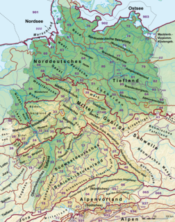
This division of Germany into major natural regions takes account primarily of geomorphological, geological, hydrological, and pedological criteria in order to divide the country into large, physical units with a common geographical basis. Political boundaries play no part in this, apart from defining the national border.
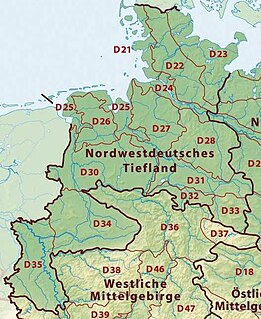
The Westphalian Lowland, also known as the Westphalian Basin is a flat landscape that mainly lies within the German region of Westphalia, although small areas also fall within North Rhine and in Lower Saxony. Together with the neighbouring Lower Rhine Plain to the west, it represents the second most southerly region of the North German Plain, after the Cologne Bight. It is variously known in German as the Westfälische Bucht, the Münsterländer or Westfälische Tieflands- or Flachlandsbucht.

The Saxon Uplands, Saxon Hills or Ore Mountain Foreland is a strip of countryside of about 200 m to 500 m above sea level (NN) high, in the German state of Saxony, that lies immediately north of the German Ore Mountains and runs mainly through the areas of Zwickauer Land, Zwickau, Chemnitzer Land, Chemnitz, Mittelsachsen and the country south of Dresden. It borders on the Upper Pleißeland to the extreme west, the Ore Mountain Basin in the south and the Mulde Loess Hills to the north and east.
The Saxon Loess Fields refer to a natural region that lies mainly within the state of Saxony in central Germany. In addition, small areas of this region extend to the northwest and west into Saxony-Anhalt, to the southeast into Thuringia and to the northeast into Brandenburg. It more-or-less combines the BfN's major regions listed as D19 Saxon Upland and Ore Mountain Foreland, and D14, Upper Lusatia (Oberlausitz); only the range of Central Uplands hills, the Lusatian Mountains, has been excluded and instead forms part of the Saxon Highlands and Uplands.
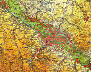
The Dresden Basin is a roughly 45 km long and 10 km wide area of the Elbe Valley between the towns of Pirna and Meißen. The city of Dresden lies in the Dresden Basin.
The Saxon-Bohemian Chalk Sandstone Region is a natural region in south Saxony on the southern border with the Czech Republic. It forms part of the northern perimeter of the Bohemian Massif and comprises Saxon Switzerland, the German part of the Elbsandsteingebirge and the Zittau Hills, a small section of the Lusatian Mountains on German soil. Because the boundary between the Elbsandsteingebirge and the Lusatian Uplands is on Czech territory, the two natural regions are physically separated.
The Saxon Highlands and Uplands refer to a natural region mainly in the south of Saxony with small elements also in southeast Thuringia and northeast Bavaria. It comprises, from (south)west to (north)east, of the Vogtland, the Ore Mountains, Saxon Switzerland, the Upper Lusatian Plateau and the Zittau Hills.

The Eastern Ore Mountains form a natural region of Saxony that covers the eastern part of the Saxon Ore Mountains range. Together with the Western and Central Ore Mountains, it is part of the larger Saxon Highlands and Uplands region. Its southern continuation beyond the German border covers an area of roughly the same extent in the Czech Republic.
The Central or Middle Ore Mountains is a natural region that forms the central-western part of the Ore Mountains in the German federal state of Saxony. It is part of the overarching unit, the Saxon Highlands and Uplands. It forms the eastern part of the former major units, the Lower Western Ore Mountains and Upper Western Ore Mountains and is separated from the Eastern Ore Mountains in the east by the (included) valley of the Flöha, and from the Western Ore Mountains in the west by the (excluded) valley of the Schwarzwasser and, below its mouth, by the Zwickauer Mulde.
The Western Ore Mountains is a natural region that forms the westernmost part of the Ore Mountains in the German state of Saxony. It is also part of the major landscape unit known as the Saxon Highlands and Uplands. It extends eastwards to include the valley of the Schwarzwasser, and, below its mouth, that of the Zwickauer Mulde, and incorporates the western parts of the former major units known as the Lower and Upper Western Ore Mountains, no. 423, as well as the Southern Slopes of the Ore Mountains, no. 420.

The Leipzig Bay(German: Leipziger Tieflandsbucht) or Leipzig Basin or Saxon Lowland or Saxon Bay is a relatively lakeless and highly fertile landscape in Central Germany, in northwestern Saxony and southeastern Saxony-Anhalt.

The classification of natural regions of Saxony shown here was produced between 1994 and 2001 by a working group called "Ecosystem and Regional Character" at the Saxonian Academy of Sciences in Leipzig as part of the research and development project "Natural Regions and Natural Region Potential of the Free State of Saxony" at a scale of 1:50,000 as the basis for the rural development and regional planning. This was also supported by the Saxon State Ministry of the Environment and Agriculture and the Saxon Ministry of the Interior.
References
- 1 2 EU Regional Profile Report for Central Europe Project 1CE084P4 "ReSOURCE" at www.central2013.eu, p. 37. Accessed on 27 Feb 2011.
- 1 2 Dickinson, Robert E (1964). Germany: A regional and economic geography (2nd ed.). London: Methuen, p. 624. ASIN B000IOFSEQ.
- 1 2 Elkins, T H (1972). Germany (3rd ed.). London: Chatto & Windus, p. 292. ASIN B0011Z9KJA.
- ↑ BfN map services Archived 2012-12-19 at the Wayback Machine (under the tab "Landschaften" each landscape fact file is clickable)
- ↑ Map of natural regions in Saxony Archived 2011-07-19 at the Wayback Machine at www.umwelt.sachsen.de (pdf, 859 kB)