Related Research Articles

The Tongass National Forest in Southeast Alaska is the largest U.S. National Forest at 16.7 million acres. Most of its area is temperate rain forest and is remote enough to be home to many species of endangered and rare flora and fauna. The Tongass, which is managed by the United States Forest Service, encompasses islands of the Alexander Archipelago, fjords and glaciers, and peaks of the Coast Mountains. An international border with Canada runs along the crest of the Boundary Ranges of the Coast Mountains. The forest is administered from Forest Service offices in Ketchikan. There are local ranger district offices located in Craig, Hoonah, Juneau, Ketchikan, Petersburg, Sitka, Thorne Bay, Wrangell, and Yakutat.

Wilderness or wildlands are Earth's natural environments that have not been significantly modified by human activity, or any nonurbanized land not under extensive agricultural cultivation. The term has traditionally referred to terrestrial environments, though growing attention is being placed on marine wilderness. Recent maps of wilderness suggest it covers roughly one-quarter of Earth's terrestrial surface, but is being rapidly degraded by human activity. Even less wilderness remains in the ocean, with only 13.2% free from intense human activity.

The protected areas of the United States are managed by an array of different federal, state, tribal and local level authorities and receive widely varying levels of protection. Some areas are managed as wilderness, while others are operated with acceptable commercial exploitation. As of 2022, the 42,826 protected areas covered 1,235,486 km2 (477,024 sq mi), or 13 percent of the land area of the United States. This is also one-tenth of the protected land area of the world. The U.S. also had a total of 871 National Marine Protected Areas, covering an additional 1,240,000 sq mi (3,200,000 km2), or 26 percent of the total marine area of the United States.
The protected areas of Michigan come in an array of different types and levels of protection. Michigan has five units of the National Park Service system. There are 14 federal wilderness areas; the majority of these are also tribal-designated wildernesses. It has one of the largest state forest systems as well having four national forests. The state maintains a large state park system and there are also regional parks, and county, township and city parks. Still other parks on land and in the Great Lakes are maintained by other governmental bodies. Private protected areas also exist in the state, mainly lands owned by land conservancies.

The Wilderness Act of 1964 is a federal land management statute meant to protect federal wilderness and to create a formal mechanism for designating wilderness. It was written by Howard Zahniser of The Wilderness Society. After over sixty drafts and eight years of work, President Lyndon B. Johnson signed the Wilderness Act into law on September 3, 1964, creating the legal definition of wilderness in the United States and protecting 9.1 million acres of federal land.

The National Wilderness Preservation System (NWPS) of the United States protects federally managed wilderness areas designated for preservation in their natural condition. Activity on formally designated wilderness areas is coordinated by the National Wilderness Preservation System. Wilderness areas are managed by four federal land management agencies: the National Park Service, the U.S. Forest Service, the U.S. Fish and Wildlife Service, and the Bureau of Land Management.
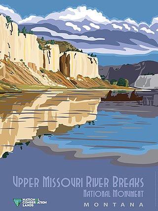
National Conservation Lands, formally known as the National Landscape Conservation System, is a 35-million-acre (140,000 km2) collection of lands in 873 federally recognized areas considered to be the crown jewels of the American West. These lands represent 10% of the 258 million acres (1,040,000 km2) managed by the Bureau of Land Management (BLM). The BLM is the largest federal public land manager and is responsible for over 40% of all the federal public land in the nation. The other major federal public land managers include the US Forest Service (USFS), National Park Service (NPS), and the US Fish and Wildlife Service (USFWS).

The William O. Douglas Wilderness is a designated wilderness in Central Washington. It includes 169,081 acres (68,425 ha) located between the U.S. Route 12 and State Route 410 and is jointly administered by the Okanogan-Wenatchee National Forest and the Gifford Pinchot National Forest. It shares a boundary with the Mount Rainier National Park on the west; Norse Peak Wilderness lies to the north, Goat Rocks Wilderness to the south. Approximately 25 miles (40 km) of the Pacific Crest Trail travel along the Cascade Range crest within its boundaries. It contains scattered peaks, sharp ridges, steep slopes and hundreds of small lakes and potholes. Much of the wilderness is drained by tributaries of the Naches River.
The Wilderness Society is an American non-profit land conservation organization that is dedicated to protecting natural areas and federal public lands in the United States. They advocate for the designation of federal wilderness areas and other protective designations, such as for national monuments. They support balanced uses of public lands, and advocate for federal politicians to enact various land conservation and balanced land use proposals. The Wilderness Society also engages in a number of ancillary activities, including education and outreach, and hosts one of the most valuable collections of Ansel Adams photographs at their headquarters in Washington, D.C.

The Opal Creek Wilderness is a wilderness area located in the Willamette National Forest in the U.S. state of Oregon, on the border of the Mount Hood National Forest. It has the largest uncut watershed in Oregon.
Roadless area conservation is a conservation policy limiting road construction and the resulting environmental impact on designated areas of public land. In the United States, roadless area conservation has centered on U.S. Forest Service areas known as inventoried roadless areas. The most significant effort to support the conservation of these efforts was the Forest Service 2001 Roadless Area Conservation Rule.
The Oregon Coast National Wildlife Refuge Complex consists of six National Wildlife Refuges along the Oregon Coast. It provides wilderness protection to thousands of small islands, rocks, reefs, headlands, marshes, and bays totaling 371 acres spanning 320 miles (515 km) of Oregon's coastline. The areas are all managed by the United States Fish and Wildlife Service.
Inventoried Roadless Areas are a group of United States Forest Service lands that have been identified by government reviews as lands without existing roads that could be suitable for roadless area conservation as wilderness or other non-standard protections. The Inventoried Roadless areas include approximately 60,000,000 acres (240,000 km2) of land in 40 states and Puerto Rico. Most of these lands are in the western portion of the lower 48 states and Alaska. Idaho alone contains over 9 million acres (36,000 km2) of inventoried roadless areas. The inventoried roadless areas range from large areas with wilderness characteristics to small tracts of land that are immediately adjacent to wilderness areas, parks and other protected lands.

Little Blitzen River is a 12.5-mile (20.1 km) tributary of the Donner und Blitzen River in the U.S. state of Oregon. Little Blitzen River rises on the west flank of Steens Mountain about 20 miles (32 km) southeast of Frenchglen and about 70 miles (110 km) south of Burns in Harney County. Flowing west in a steep-walled canyon, it joins the South Fork Donner und Blitzen River at 42.6737752°N 118.7935277°W to form the Donner und Blitzen main stem, which continues north about another 40 miles (64 km) to its mouth at 43.291542°N 118.8199273°W in Malheur Lake. The Donner und Blitzen River was named by soldiers of German origin and translates as "thunder and lightning". Little Blitzen River brings to mind one of Santa Claus's reindeer.
Conservation in the United States can be traced back to the 19th century with the formation of the first National Park. Conservation generally refers to the act of consciously and efficiently using land and/or its natural resources. This can be in the form of setting aside tracts of land for protection from hunting or urban development, or it can take the form of using less resources such as metal, water, or coal. Usually, this process of conservation occurs through or after legislation on local or national levels is passed.
Sleeping Giant Wilderness Study Area is a non-motorized recreation area located on the west side of the Missouri River and Holter Lake located about 30 miles (48 km) north of Helena, Montana. Designated as a wilderness study area in 1981, the Sleeping Giant Wilderness Study Area contains approximately 6,666 acres (2,698 ha) of nearly roadless land, about half of which is forested. A portion of the Lewis and Clark National Historic Trail is contained inside the study area.

The French Pete Trail is a 9.9-mile (15.9 km) hiking trail in the valley of French Pete Creek in the Three Sisters Wilderness of western Oregon. The trail passes through low-elevation old-growth forest that was a nationwide political issue in the 1960s and 1970s because of conflicting plans for logging and for wilderness designation, respectively. In 1978, the U.S. Congress passed a bill adding the French Pete area to the Three Sisters Wilderness.
The Southeast Alaska Conservation Council (SEACC) is a non-profit organization that focuses on protecting the lands and waters of Southeast Alaska. They promote conservation and advocate for sustainable natural resource management. SEACC is located in the capital city of Alaska, Juneau. The environmental organization focuses on concerns in the Southeast region of Alaska, including the areas of the Panhandle, the Tongass National Forest, and the Inside Passage.
Long Spur is a wildland in the George Washington and Jefferson National Forests of western Virginia. The Wilderness Society has designated the area as a "Mountain Treasure," as a special place worthy of protection from logging and road construction.