
The Giant's Causeway is an area of about 40,000 interlocking basalt columns, the result of an ancient volcanic fissure eruption. It is located in County Antrim on the north coast of Northern Ireland, about three miles (4.8 km) northeast of the town of Bushmills.

Devils Postpile National Monument is a U.S. National Monument located near Mammoth Mountain in Eastern California. The monument protects Devils Postpile, an unusual rock formation of columnar basalt, "all closely and perfectly fitted together like a vast mosaic." The monument encompasses 798 acres (323 ha) and includes two main attractions: the Devils Postpile formation and Rainbow Falls, a waterfall on the Middle Fork of the San Joaquin River. In addition, the John Muir Trail and Pacific Crest Trail merge into one trail as they pass through the monument. Excluding a small developed area containing the monument headquarters, visitor center and a campground, the National Monument lies within the borders of the Ansel Adams Wilderness.

Kilbourne Hole is a maar volcanic crater, located 30 miles (48 km) west of the Franklin Mountains of El Paso, Texas, in the Potrillo volcanic field of Doña Ana County, New Mexico. Another maar, Hunt's Hole, lies just two miles (3.2 km) south. Kilbourne Hole is notable for the large number of mantle xenoliths that were carried to the surface by the eruption.

Hallgrímskirkja is a Lutheran parish church in Reykjavík, Iceland. At 74.5 metres (244 ft) tall, it is the largest church in Iceland and among the tallest structures in the country. Known for its distinctively curved spire and side wings, it has been described as having become an important symbol for Iceland's national identity since its completion in 1986. The church is named after the Icelandic poet and cleric Hallgrímur Pétursson (1614–1674), author of the Passion Hymns.

Mount Cargill, known in Māori as Kapukataumahaka, is a volcanic outcrop which dominates the skyline of northern Dunedin, New Zealand.

Trap rock, also known as either trapp or trap, is any dark-colored, fine-grained, non-granitic intrusive or extrusive igneous rock. Types of trap rock include basalt, peridotite, diabase, and gabbro. Trap is also used to refer to flood (plateau) basalts, e.g. the Deccan Traps and Siberian Traps. The erosion of trap rock created by the stacking of successive lava flows often created a distinct stairstep landscape from which the term trap was derived from the Swedish word trappa, which means "stairway".

Khorixas is a town with about 6,000 inhabitants in the southern part of the Kunene Region, Namibia. It was the capital of the Damaraland bantustan before Namibia's independence. It is the administrative capital of Khorixas Constituency. Most of the inhabitants are from the Damara ethnic group. The town is located near the Petrified Forest, Khorixas - a deposit of petrified wood and well known tourist attraction of Namibia. The Twyfelfontein valley, known for its rock art, is also accessible from Khorixas.
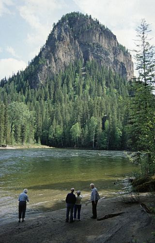
White Horse Bluff is a subaqueous volcano in Wells Gray Provincial Park, east-central British Columbia, Canada.

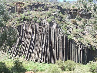
Columnar jointing is a geological structure where sets of intersecting closely spaced fractures, referred to as joints, result in the formation of a regular array of polygonal prisms, or columns. Columnar jointing occurs in many types of igneous rocks and forms as the rock cools and contracts. Columnar jointing can occur in cooling lava flows and ashflow tuffs (ignimbrites), as well as in some shallow intrusions. Columnar jointing also occurs rarely in sedimentary rocks, due to a combination of dissolution and reprecipitation of interstitial minerals by hot, hydrothermal fluids and the expansion and contraction of the rock unit, both resulting from the presence of a nearby magmatic intrusion.
Peter's Rock, also known as Rabbit Rock, Rabbit Hill, Indian Rock and Great Rock, with a high point of (est.) 373 feet (114 m) above sea level, is a trap rock peak located 4 miles (6 km) northeast of downtown New Haven, Connecticut in the town of North Haven. It is part of the Metacomet Ridge that extends from Long Island Sound near New Haven, north through the Connecticut River Valley of Massachusetts to the Vermont border. Peter's Rock is known for its scenic views, unique microclimate ecosystems, rare plant communities, and columnar basalt rock formations. It is traversed by a number of hiking trails managed by the non-profit Peter's Rock Association.
The Organ Pipes National Park, abbreviated as OPNP, is a national park located in the Central region of Victoria, Australia. The 121-hectare (300-acre) protected area was established with the focus on conservation of the native flora and fauna, and preservation of the geological features in the Jacksons Creek, a part of the Maribyrnong valley, north-west of Melbourne. It is situated in a deep gorge in the grassy, basalt Keilor Plains.
The Mühlsteinbrüche south of Jonsdorf in the Zittau Mountains in Saxony are a region of bizarre rock formations, which have been formed by the quarrying of sandstone for millstones and also by weathering processes. They are a popular hiking and climbing area. An educational trail runs through the region which has an area of about 35 hectares.

The Catoctin Formation is a geologic formation that expands through Virginia, Maryland, and Pennsylvania. It dates back to the Precambrian and is closely associated with the Harpers Formation, Weverton Formation, and the Loudoun Formation. The Catoctin Formation lies over the a granite basement rock and below the Chilhowee Group making it only exposed on the outer parts of the Blue Ridge. The Catoctin Formation contains metabasalt, metarhyolite, and porphyritic rocks, columnar jointing, low-dipping primary joints, amygdules, sedimentary dikes, and flow breccias. Evidence for past volcanic activity includes columnar basalts and greenstone dikes.

The Burnt Mountain is a hill with a solidified lava flow at the foot of a 12-kilometre-long volcanic ridge in Damaraland in northern Namibia. The 80-million-year-old stream of lava was formed by thermal and compression metamorphism and its red, brown, cream and purple colours creates a striking contrast at dusk with the surrounding 200-million-year-old beige rocks of Karoo slate.
The geology of Lesotho is built on ancient crystalline basement rock up to 3.6 billion years old, belonging to the Kaapvaal Craton, a section of stable primordial crust. Most of the rocks in the country are sedimentary or volcanic units, belonging to the Karoo Supergroup. The country is notable for large fossil deposits and intense erosion due to high rainfall and a rare case of southern African glaciation during the last ice age. Lesotho has extensive diamonds and other natural resources and has the highest concentration of kimberlite pipes anywhere in the world.

The geology of Namibia encompasses rocks of Paleoproterozoic, Mesoproterozoic and Neoproterozoic and Paleozoic to Cenozoic age. About 46% of the countryʼs surface are bedrock exposure, while the remainder is covered by the young overburden sediments of the Kalahari and Namib deserts.

The Drakensberg Group is a geological group named after the Drakensberg mountain range where in its uppermost sections the rocks are found. The Drakensberg Group lies over most of Lesotho and localities in the Eastern Cape, KwaZulu-Natal, and Free State provinces of South Africa. It forms part of the greater Karoo Igneous Province, which occurs over an extensive area of southern Africa.

The Alaji (upper) Basalts are the youngest series of the Ethiopian flood basalts. The most recent flows are only 15 million years old.
The Ashangi Basalts are the earliest Tertiary volcanic rocks in north Ethiopia, hence they are in the lowest position. These dark porphyritic basalts are separated from the Mesozoic formations below it by basal conglomerates. The basalts hold phenocrysts that developed before the magma reached the earth surface. These basalts are weathered, partially eroded and have a sub-horizontal stratification, particularly at the lower part. This series was created during the first period of the flood basalt eruptions in north Ethiopia, in the Oligocene.
