Related Research Articles

The Santa Rosa Mountains are a short mountain range in the Peninsular Ranges system, located east of the Los Angeles Basin and northeast of the San Diego metropolitan area of southern California, in the southwestern United States.

Boulevard is a census-designated place (CDP) in the Mountain Empire area of southeastern San Diego County, California. At that time, it had a population of 359 at the 2020 United States census, up from 315 2010 United States census. The area is rural high desert along the Mexican border near the eastern extent of San Diego County.

Campo is an unincorporated community in the Mountain Empire area of southeastern San Diego County, California, United States. The population was 2,955 at the 2020 United States census, up from 2,684 at the 2010 census. For statistical purposes, the United States Census Bureau has defined Campo as a census-designated place (CDP). The census definition of the area may not precisely correspond to local understanding of the area with the same name.

The Pine Valley Creek Bridge, officially named the Nello Irwin Greer Memorial Bridge, is a reinforced concrete box girder bridge in San Diego County, California near the town of Pine Valley. The bridge was built in 1974 as part of the Interstate 8 (I-8) freeway system. At the time of its construction, it was the first bridge constructed in the United States using the segmental balanced cantilever method.

The Mojave Road, also known as Old Government Road, is a historic route and present day dirt road across what is now the Mojave National Preserve in the Mojave Desert in the United States. This rough road stretched 147 miles (237 km) from Beale's Crossing, to Fork of the Road location along the north bank of the Mojave River where the old Mojave Road split off from the route of the Old Spanish Trail/Mormon Road.

San Timoteo Canyon is a river valley canyon southeast of Redlands, in the far northwestern foothills of the San Jacinto Mountains in the Inland Empire region of Southern California.

The Mountain Empire is a rural area in southeastern San Diego County, California. The Mountain Empire subregion consists of the backcountry communities in southeastern San Diego County. The area is also sometimes considered part of the East County region of San Diego County.
Earthquake Valley is a desert valley east of Julian, California, which contains parts of the Anza-Borrego Desert State Park. It is the location of the Shelter Valley Ranchos subdivision, which is also known as the unincorporated community of Shelter Valley. The official USGS place name for the geologic feature in which Shelter Valley is situated is "Earthquake Valley", and the 1959 USGS Topographic map makes no reference to Shelter Valley. The name of the unincorporated community Shelter Valley is typically used both locally and by the media to refer generally to the geological feature of Earthquake Valley, and it is common for both names to be referenced in publications after the 1962 establishment of the subdivision. Author, poet, artist and primitivist Marshal South lived in and wrote about the general area, in a series of articles for Desert Magazine between 1941 and 1948. A number of notable trails pass through the valley, including the Pacific Crest Trail, the California Riding and Hiking Trail, and the Southern Emigrant Trail.
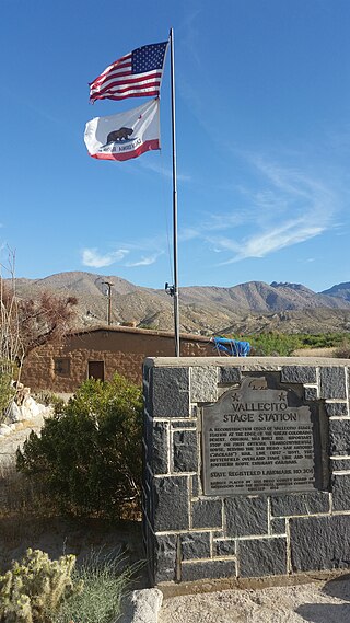
Vallecito, in San Diego County, California, is an oasis of cienegas and salt grass along Vallecito Creek and a former Kumeyaay settlement on the edge of the Colorado Desert in the Vallecito Valley. Its Spanish name is translated as "little valley". Vallecito was located at the apex of the gap in the Carrizo Badlands created by Carrizo Creek and its wash in its lower reach, to which Vallecito Creek is a tributary. The springs of Vallecito, like many in the vicinity, are a product of the faults that run along the base of the Peninsular Ranges to the west.
Green Valley, is a valley in the Cuyamaca Mountains in San Diego County, California. The Sweetwater River flows through Green Valley, and has its source at the top of Upper Green Valley.
The Carrizo Creek and Carrizo Wash in California are a stream and an arroyo that the stream flows into, in San Diego County, California, and Imperial County, California.
San Felipe Creek is a stream in Imperial and San Diego Counties of California. It arises in the Volcan Mountains of San Diego County 33°11′57″N116°37′35″W, and runs eastward, gathering the waters of most of the eastern slope of the mountains and desert of the county in the San Sebastian Marsh before it empties into the Salton Sea. It is probably the last remaining perennial natural desert stream in the Colorado Desert region. In 1974, the San Felipe Creek Area was designated as a National Natural Landmark by the National Park Service.
Butterfield Valley is a valley along the course of Temecula Creek, in Riverside County, California. Its lower end is now filled by Vail Lake. It heads at 33°27′39″N116°55′34″W and its mouth is at the site of the Vail Lake Dam at the head of the deep canyon Temecula Creek has cut through Oak Mountain to the Pauba Valley.
Mason Valley is a valley in San Diego County, California. Mason Valley was named after a settler, James E. Mason who established a ranch in the valley in the later 19th century. The mouth of the valley is at an elevation of 1,995 feet / 608 meters, at the point where the valley narrows into a canyon where the Vallecito Wash continues as Vallecito Creek and passes between the Sawtooth Range and the Vallecito Mountains. The head of Mason Valley is at an elevation of 2550 feet at 33°01′05″N116°28′53″W at the junction of Oriflamme Canyon and Rodriguez Canyon where Vallecito Wash has its source.
Vallecito Wash is a wash part of Vallecito Creek, a tributary stream of Carrizo Creek, in San Diego County, California.
Rodriguez Canyon is a steep mountain canyon, in San Diego County, California. It has its head at 33°02′55″N116°31′43″W at an elevation of 4,120 feet in the Cuyamaca Mountains. Is mouth is at 2,549 feet, at its confluence with Oriflamme Canyon, where they form the head of Vallecito Wash, at the northwestern end of Mason Valley.
Upper Green Valley is a valley in the Cuyamaca Mountains in San Diego County, California. Its mouth lies at an elevation of 4,163 feet / 1,269 meters. Its head is at 32°59′03″N116°32′01″W, at an elevation of 4,890 feet. The Sweetwater River has its source at the top of Upper Green Valley.
Devils Canyon is a steep canyon in the Jacumba Mountains in Imperial and San Diego County, California, United States. Its mouth is located at an elevation of 1,109 feet (338 m) in Imperial County. Its head is at an elevation of 3,560 feet (1,090 m) at 32°41′06″N116°08′42″W in the Jacumba Mountains in San Diego County.

Carrizo Gorge is a valley in the Jacumba Mountains, in San Diego County, California. Its mouth is at an elevation of 1,411 feet (430 m), where it widens out to become Carrizo Canyon, 1 mi (1.6 km) northeast of Palm Grove. Its head is located in the Jacumba Mountains, 1.5 mi (2.4 km) north of Round Mountain, at an elevation of 2,600 ft (790 m) at 32°39′38″N116°11′28″W.
Anza Valley, formerly known as the Hamilton Plains, is a basin in Riverside County, California. Anza Valley trends southwest from Bautista Canyon, west of Thomas Mountain to Terwilliger Valley, 2.8 miles west-southwest of Table Mountain and 12 miles south of Idyllwild. The valley lies at an elevation of 4,157 feet (1,267 m), west of the San Jacinto and Santa Rosa Mountains. It is drained by Cahuilla Creek, a tributary of the Santa Margarita River.
References
33°01′05″N116°29′03″W / 33.01806°N 116.48417°W
| | This San Diego County, California–related article is a stub. You can help Wikipedia by expanding it. |