Orleans, Santa Catarina

Last updated
Orleans highlighted in Santa Catarina. SantaCatarina Municip Orleans.svg
Orleans highlighted in Santa Catarina.

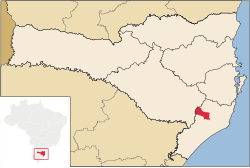
Orleans is a Brazilian municipality in the state of Santa Catarina. The town is located in the south of the state. As of 2020, the estimated population was 23,038. [1]

The municipality contains part of the 1,330 hectares (3,300 acres) Serra Furada State Park, created in 1980. [2]

History

Named after emperor Dom Pedro II's son-in-law, Gaston, Count of Eu, from the House of Orléans on December 26, 1884. [3] It was first colonized by Italians, then Germans, Austrians, Poles, Norwegians, Latvians, Dutch and other nationalities from Europe. [4] [5] [6]

Related Research Articles

Santa Catarina (state) State of Brazil

Santa Catarina is a state in the South Region of Brazil. It is the 7th smallest state in total area and the 11th most populous. Additionally, it is the 9th largest settlement, with 295 municipalities. The state, which has 3.4% of the Brazilian population, is responsible for 3.8% of the Brazilian GDP.

Chapecó City in South, Brazil

Chapecó is a municipality in the state of Santa Catarina, in the Southern Region of Brazil. Being a major industrial, financial and educational center, it is a major producer of industrialized food products. Considered a medium city, with a population estimated at 224,013 inhabitants, it is among the four most important cities in the state. It belongs to the Meso-region of Western Santa Catarina and to the Microregion of Chapecó.

Armazém is a municipality in the Brazilian state of Santa Catarina. Is located at latitude 28º15'43" south and longitude 49º01'03" west, with an altitude of 30 meters. The city's streets are embellished with manicured gardens. Armazém has an area of 138.6 km ² and was emancipated from the city of Tubarão on December 19, 1958.

Criciúma Place in South, Brazil

Criciúma is a city in the Brazilian state of Santa Catarina. At 28°40′39″S49°22′11″W, it is located 180 km south of Florianópolis, the state capital and around 900 km south of São Paulo. The city is the center of Brazil's flooring and home materials industry, and is the second-largest such center in the world.

Gramado Town in South, Brazil

Gramado is a small tourist city, southeast of Caxias do Sul and east of Nova Petrópolis in the southern Brazilian state of Rio Grande do Sul, in the Serra Gaúcha region. The city was originally settled by Azorean descendants and later received a contingent of German and Italian immigrants. Gramado is one of the cities along the scenic route known as Rota Romântica.

Mooca (district of São Paulo) District of São Paulo, Brazil

Mooca from tupi mo-oka, meaning to build houses, is a district in the subprefecture of the same name in the city of São Paulo, Brazil. Mooca today is home to over 75,000 inhabitants, spread in its 7.7 square kilometres (3.0 sq mi). It is also considered one of the fastest growing districts in the city, experiencing over the last years a vigorous momentum in the construction industry. Mooca has been the stage for many social movements, specially because of the presence of a strong influence of the industry interests in the political scene of São Paulo towards the end of the 19th century and the beginning of the 20th century. The composition of Mooca's economy today ranges from small businesses ran by locals, large industries, such as Lorenzetti and Groupe SEB, both important players locally and globally in the home appliances industry, and ultimately, large shopping malls offering a variety of services.

Itajaí Municipality in Southern, Brazil

Itajaí is a municipality in the state of Santa Catarina, Brazil. It is located on the northern central coast of Santa Catarina and is part of the Vale do Itajaí Mesoregion, on the right bank of the Itajaí-Açu river mouth. It lies at the mouth of the Itajaí River, at 20 feet above sea level. The city has the 2nd largest gross domestic product and the highest per capita income in the State of Santa Catarina.

Czech Brazilians refer to Brazilians of Czech descent who were born in or who trace their ancestry to the territory of the historic Czech lands or succession states, now known as the Czech Republic, and are residents and/or citizens of Brazil.

São Joaquim National Park

São Joaquim National Park is a National park in the state of Santa Catarina, Brazil.

São Joaquim Municipality in South, Brazil

São Joaquim is a municipality in the state of Santa Catarina, situated in southern Brazil. It is located at latitude 28° 17' 38" south and longitude 49° 55' 54" west, with an altitude of 1,360 meters (4,460 ft). Its population in 2020 was 27,139 inhabitants. Located in the Planalto Serrano, it lies 136 km from Tubarão, 81 km from Lages and 227 km from Florianópolis. The town is home to a variety of ethnic groups, including Italian, Portuguese, Japanese and Afro- Brazilians, though composed mainly of descendants of German and Swedish immigrants. There is also a large proportation of the population from other states in Brazil, especially from Rio Grande do Sul.

Serra do Rio do Rastro

Serra do Rio do Rastro is a mountain range located in the southeast of the state of Santa Catarina, Southern Brazil. It is crossed by the road SC-390, with remarkable landscapes and deep cliffs.

Faxinal dos Guedes City in South, Brazil

Faxinal dos Guedes is a Brazilian Municipality located in the state of Santa Catarina, in the Southern Region of Brazil. It is located in the Immediate Geographical Region of Xanxerê and in the Intermediate Geographical Region of Chapecó and at 307 miles away from the capital of Santa Catarina, Florianópolis. Its estimated population in 2016, according to the IBGE, was 10,649 inhabitants. It is the second municipality in highest elevation of the west of Santa Catarina being to 3297,244 ft of the level of the sea.

Gravatal Municipality in South, Brazil

Gravatal is a municipality in the state of Santa Catarina in the South region of Brazil.

Imaruí Municipality in South, Brazil

Imaruí is a municipality in the state of Santa Catarina in the South region of Brazil.

Grão Pará Municipality in South, Brazil

Grão-Pará is a municipality in the state of Santa Catarina in the South region of Brazil.

Treviso, Santa Catarina is a municipality in the state of Santa Catarina in the South region of Brazil.

Urussanga Municipality in South, Brazil

Urussanga is a municipality in the state of Santa Catarina in the South region of Brazil. The name means "very cold water" in the Tupi language.

Snow in Brazil The frequency of snow in Brazil

Snow in Brazil occurs yearly in the high plains of the country's South Region. Elsewhere in the country it is a rare phenomenon but has been registered several times.

Serra Furada State Park

The Serra Furada State Park is a state park in the state of Santa Catarina, Brazil. It protects a densely forested mountain region of dramatic beauty in the Atlantic Forest biome.

BR-470 Highway in Brazil

BR-470 is an east-west Brazilian federal highway that starts in Navegantes, Santa Catarina, and crosses the Gaucho range and highlands. It stretches approximately 833 km, passing through cities such as Itajaí, Blumenau, Rio do Sul, Curitibanos, Campos Novos, Bento Gonçalves, Veranópolis and Montenegro and ends in Camaquã, Rio Grande do Sul.

References

  1. IBGE 2020
  2. Parque Estadual da Serra Furada (in Portuguese), FATMA: Fundação do Meio Ambiente, retrieved 2017-02-04
  3. "História da Prefeitura municipal de Orleans". orleans.sc.gov.br. Retrieved 19 October 2016.
  4. "História da Prefeitura municipal de Orleans". orleans.sc.gov.br. Retrieved 19 October 2016.
  5. "Imigração da Europa a Santa Catarina". hafemann.br. Retrieved 19 October 2016.
  6. "Imigração no Brasil". weber-ruiz.com. Retrieved 19 October 2016.

Coordinates: 28°21′S49°18′W / 28.350°S 49.300°W / -28.350; -49.300