
Geodesy or geodetics is the science of measuring and representing the geometry, gravity, and spatial orientation of the Earth in temporally varying 3D. It is called planetary geodesy when studying other astronomical bodies, such as planets or circumplanetary systems. Geodesy is an earth science as well as a discipline of applied mathematics, and many consider the study of Earth's shape and gravity to be central to the science.
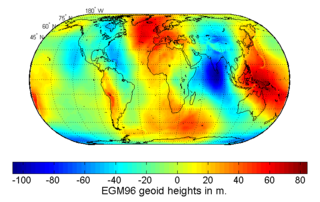
The geoid is the shape that the ocean surface would take under the influence of the gravity of Earth, including gravitational attraction and Earth's rotation, if other influences such as winds and tides were absent. This surface is extended through the continents. According to Gauss, who first described it, it is the "mathematical figure of the Earth", a smooth but irregular surface whose shape results from the uneven distribution of mass within and on the surface of Earth. It can be known only through extensive gravitational measurements and calculations. Despite being an important concept for almost 200 years in the history of geodesy and geophysics, it has been defined to high precision only since advances in satellite geodesy in the late 20th century.

Physical geodesy is the study of the physical properties of Earth's gravity and its potential field, with a view to their application in geodesy.

The World Geodetic System (WGS) is a standard used in cartography, geodesy, and satellite navigation including GPS. The current version, WGS 84, defines an Earth-centered, Earth-fixed coordinate system and a geodetic datum, and also describes the associated Earth Gravitational Model (EGM) and World Magnetic Model (WMM). The standard is published and maintained by the United States National Geospatial-Intelligence Agency.

The National Geodetic Survey (NGS) is a United States federal agency based in Washington, D.C. that defines and manages a national coordinate system, providing the foundation for transportation and communication, mapping and charting, and a large number of science and engineering applications. Since its founding in 1970, it has been part of the National Oceanic and Atmospheric Administration (NOAA), a division within the United States Department of Commerce.
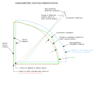
The vertical deflection (VD) or deflection of the vertical (DoV), also known as deflection of the plumb line and astro-geodetic deflection, is a measure of how far the gravity direction at a given point of interest is rotated by local mass anomalies such as nearby mountains. They are widely used in geodesy, for surveying networks and for geophysical purposes.
A geodetic datum or geodetic system is a global datum reference or reference frame for precisely representing the position of locations on Earth or other planetary bodies by means of geodetic coordinates. Datums are crucial to any technology or technique based on spatial location, including geodesy, navigation, surveying, geographic information systems, remote sensing, and cartography. A horizontal datum is used to measure a location across the Earth's surface, in latitude and longitude or another coordinate system; a vertical datum is used to measure the elevation or depth relative to a standard origin, such as mean sea level (MSL). Since the rise of the global positioning system (GPS), the ellipsoid and datum WGS 84 it uses has supplanted most others in many applications. The WGS 84 is intended for global use, unlike most earlier datums.

The elevation of a geographic location is its height above or below a fixed reference point, most commonly a reference geoid, a mathematical model of the Earth's sea level as an equipotential gravitational surface . The term elevation is mainly used when referring to points on the Earth's surface, while altitude or geopotential height is used for points above the surface, such as an aircraft in flight or a spacecraft in orbit, and depth is used for points below the surface.

The term benchmark, bench mark, or survey benchmark originates from the chiseled horizontal marks that surveyors made in stone structures, into which an angle iron could be placed to form a "bench" for a leveling rod, thus ensuring that a leveling rod could be accurately repositioned in the same place in the future. These marks were usually indicated with a chiseled arrow – specifically a broad arrow – below the horizontal line. A benchmark is a type of survey marker.
Normal heights is a type of height above sea level introduced by Mikhail Molodenskii. The normal height of a point is computed as the quotient of a point's geopotential number, by the average, normal gravity computed along the plumb line of the point.
Mikhail Sergeyevich Molodenskii was a Russian physical geodesist. He was once said to be "probably the only geodesist who would have deserved a Nobel Prize".

The North American Datum (NAD) is the horizontal datum now used to define the geodetic network in North America. A datum is a formal description of the shape of the Earth along with an "anchor" point for the coordinate system. In surveying, cartography, and land-use planning, two North American Datums are in use for making lateral or "horizontal" measurements: the North American Datum of 1927 (NAD 27) and the North American Datum of 1983 (NAD 83). Both are geodetic reference systems based on slightly different assumptions and measurements.
The National Geodetic Vertical Datum of 1929 is the official name since 1973 of the vertical datum established for vertical control surveying in the United States of America by the General Adjustment of 1929. Originally known as Sea Level Datum of 1929, NGVD 29 was determined and published by the United States Coast and Geodetic Survey and used to measure the elevation of a point above and depression below mean sea level (MSL).
The North American Vertical Datum of 1988 is the vertical datum for orthometric heights established for vertical control surveying in the United States of America based upon the General Adjustment of the North American Datum of 1988.
An Earth ellipsoid or Earth spheroid is a mathematical figure approximating the Earth's form, used as a reference frame for computations in geodesy, astronomy, and the geosciences. Various different ellipsoids have been used as approximations.

In geodesy, surveying, hydrography and navigation, vertical datum or altimetric datum is a reference coordinate surface used for vertical positions, such as the elevations of Earth-bound features and altitudes of satellite orbits and in aviation. In planetary science, vertical datums are also known as zero-elevation surface or zero-level reference.

The National Spatial Reference System (NSRS), managed by the National Geodetic Survey (NGS), is a coordinate system that includes latitude, longitude, elevation, and other values. The NSRS consists of a National Shoreline, the NOAA CORS Network, a network of permanently marked points, and a set of models that describe dynamic geophysical processes affecting spatial measurements. The system is based on the datums NAD 83 and NAVD 88.

Geodetic coordinates are a type of curvilinear orthogonal coordinate system used in geodesy based on a reference ellipsoid. They include geodetic latitude (north/south) ϕ, longitude (east/west) λ, and ellipsoidal heighth. The triad is also known as Earth ellipsoidal coordinates.
Dynamic height is a way of specifying the vertical position of a point above a vertical datum; it is an alternative for orthometric height or normal height. It can be computed by dividing the location's geopotential number by the normal gravity at 45 degree latitude and zero height, a constant value . Dynamic heights are usually chosen so that zero corresponds to the geoid.
Vertical position or vertical location is a position along a vertical direction above or below a given vertical datum . Vertical distance or vertical separation is the distance between two vertical positions. Many vertical coordinates exist for expressing vertical position: depth, height, altitude, elevation, etc. Points lying on an equigeopotential surface are said to be on the same vertical level, as in a water level.
