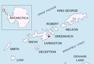
Ortiz Point is an ice-covered point on the northwest coast of Discovery Bay, Greenwich Island in the South Shetland Islands, Antarctica named after Engineman Ortiz, member of the expedition.

Ortiz Point is an ice-covered point on the northwest coast of Discovery Bay, Greenwich Island in the South Shetland Islands, Antarctica named after Engineman Ortiz, member of the expedition.
The point is located at 62°28′23.7″S59°45′30.2″W / 62.473250°S 59.758389°W which is 3.7 km south-southwest of Spark Point, 2.17 km southwest of Serrano Point, 5.35 km west-southwest of Ash Point, 3 km north-northwest of Labbé Point and 2.15 km north by west of Riquelme Point (Chilean mapping in 1951, British in 1968, and Bulgarian in 2005 and 2009).

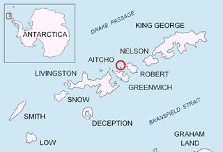
Kabile Island is an Antarctic island extending 700 m (770 yd) in south–north direction and 450 m (490 yd) wide, situated off the north coast of Greenwich Island in the South Shetland Islands, Antarctica. It has a surface area of 19 hectares.

Magura Glacier on the southeast side of Tangra Mountains on Livingston Island in the South Shetland Islands, Antarctica is located to the north of M'Kean Point, northeast of Srebarna Glacier, south of Iskar Glacier and southwest of Dobrudzha Glacier. It is bounded by Great Needle Peak to the west, Vitosha Saddle, Vihren Peak and Helmet Peak to the northwest, Plovdiv Peak and Shishman Peak to the north, and Devin Saddle and Kuber Peak to the northeast. The glacier extends 3.5 km in southwest-northeast direction and 1.9 km in northwest-southeast direction, and flows southeastward into Bransfield Strait.

Malamir Knoll rises to 200 m in the southeast extremity of the Dryanovo Heights, Greenwich Island in the South Shetland Islands, Antarctica. It has precipitous and ice-free southwest slopes and was named after the Bulgarian ruler Khan Malamir, 831-836 AD.

Murgash Glacier is the 3.4 km long and 3.2 km wide glacier on Greenwich Island in the South Shetland Islands, Antarctica situated southeast of Yakoruda Glacier, south of Teteven Glacier, southwest of Traub Glacier and west-northwest of Bravo Glacier. It is bounded by Lloyd Hill on the northwest, Tile Ridge on the east and Hebrizelm Hill on the southeast, and drains southwards into Kramolin Cove in McFarlane Strait between Yovkov Point and Kaspichan Point.

Musala Glacier on Greenwich Island in the South Shetland Islands, Antarctica is situated northeast of Targovishte Glacier, east-northeast of Zheravna Glacier and southeast of Fuerza Aérea Glacier. It is bounded by St. Kiprian Peak to the south, Vratsa Peak to the southwest, central Breznik Heights to the west, and Ilarion Ridge bordering Hardy Cove to the northeast, extends 2 nautical miles in east-west direction and 1.2 nautical miles in north-south direction, and drains eastwards into Bransfield Strait north of Fort Point.

Pautalia Glacier is a small glacier on Burgas Peninsula, Livingston Island in the South Shetland Islands, Antarctica situated northeast of Strandzha Glacier and south of Sopot Ice Piedmont. It is bounded by Petko Voyvoda Peak to the west, Sozopol Gap to the northwest, Kaloyan Nunatak to the north and Shabla Knoll to the east. The glacier extends 700 m in northwest-southeast direction and 1.1 km in southwest-northeast direction, and flows southeastward into Bransfield Strait.

Rila Point is a low, ice-free point on the south coast of Moon Bay, projecting 330 m west-northwestwards from Burgas Peninsula on Livingston Island in the South Shetland Islands, Antarctica, and forming the east side of the entrance to Bruix Cove. The point is named after Rila Mountain, Bulgaria.

Terter Peak is an ice-covered peak rising to 570 m in Breznik Heights, Greenwich Island in the South Shetland Islands, Antarctica surmounting Wulfila Glacier to the southwest, Solis Glacier to the northwest and Zheravna Glacier to the southeast.

Wulfila Glacier is located on the southern slopes of Breznik Heights, Greenwich Island in the South Shetland Islands, Antarctica, south-southwest of Solis Glacier and west of Zheravna Glacier. It is bounded by Oborishte Ridge to the northwest, Nevlya Peak to the north, Terter Peak and Razgrad Peak to the northeast, and Ephraim Bluff to the southeast. The glacier extends 3 km in northwest–southeast direction and 2 km in northeast–southwest direction. It drains southwestwards into McFarlane Strait between Ephraim Bluff and the base of Provadiya Hook, feeding the head of Doris Cove.

Kaspichan Point is a point on the southeast side of the entrance to Kramolin Cove on the southwest coast of Greenwich Island, Antarctica. Situated next west of Hebrizelm Hill, 1.4 km northwest of Triangle Point, 2 km south-southwest of Tile Ridge, and 2 km southeast of Yovkov Point. Shape enhanced by recent glacier retreat northwest of the point. Bulgarian topographic survey Tangra 2004/05. Named after the town of Kaspichan in northeastern Bulgaria.

Crutch Peaks is a dark, rocky ridge extending 900 m in north-south direction and rising to 275 m in the north extremity of Dryanovo Heights, Greenwich Island in the South Shetland Islands, Antarctica. The peak surmounts Yakoruda Glacier to the south-southwest, Teteven Glacier to the south-southeast, and Miletich Point and Kabile Island to the north.

Stoker Island is a rocky island lying off the north coast of Greenwich Island in the South Shetland Islands, Antarctica. Extending 550 by 400 m, surface area 20 hectares. The area was visited by early 19th century sealers.

Ongley Island is a rugged rocky island lying off the north coast of Greenwich Island in the South Shetland Islands, Antarctica. Extending 1.35 km (0.84 mi) in west-northwest direction and 470 m (510 yd) wide, with a surface area of 44 hectares. The area was visited by early 19th century sealers.

Romeo Island is a rocky island lying off the north coast of Greenwich Island and west of Aitcho Islands in the South Shetland Islands, Antarctica. Extending 1.35 km (0.84 mi) in west-northwest direction and 470 m (510 yd) wide, with a surface area of 44 hectares. The area was visited by early 19th century sealers.

Rousseau Peak is a peak rising to 272 m in the north of Breznik Heights, Greenwich Island in the South Shetland Islands, Antarctica and surmounting Sotos Point to the west-northwest and Fuerza Aérea Glacier to the north, west and south. Precipitous, rocky west slopes.

Labbé Point is a point projecting 600 m (660 yd) into the southwest part of Discovery Bay from Parvomay Neck, Greenwich Island in the South Shetland Islands, Antarctica with an adjacent ice-free area of 11 hectares. The point forms the northwest side of the entrance to Basullo Cove and the east side of the entrance to Vinett Cove. The small Basso Island is linked by a mainly submerged spit to the north side of Labbé Point.

Aspis Island is a small, low-lying, ice-free island rising to 15 metres (49 ft), easternmost in the Dunbar group off the northwest coast of Varna Peninsula, Livingston Island in the South Shetland Islands, Antarctica.

Riquelme Point is a point projecting 450 m into the southwest part of Discovery Bay from Parvomay Neck, Greenwich Island in the South Shetland Islands, Antarctica and forming the west side of the entrance to Vinett Cove.

Serrano Point is an ice-free point on the northwest coast of Discovery Bay, Greenwich Island in the South Shetland Islands, Antarctica named by the 1947 Chilean Antarctic Expedition after First Lieutenant Fernando Serrano, doctor on the expedition frigate Iquique.

La Morenita is a conspicuous rocky hill rising to 93 m in the southwest extremity of Half Moon Island in the South Shetland Islands, Antarctica. It surmounts the Argentine Antarctic base Cámara situated in its northern foothills, Menguante Cove to the northeast and Mugla Passage to the south. The area was visited by early 19th century sealers operating from nearby Yankee Harbour.