Serrano Point

Last updated
Location of Greenwich Island in the South Shetland Islands. Greenwich-Island-location-map.png
Location of Greenwich Island in the South Shetland Islands.

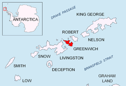
Serrano Point is an ice-free point on the northwest coast of Discovery Bay, Greenwich Island in the South Shetland Islands, Antarctica named by the 1947 Chilean Antarctic Expedition after First Lieutenant Fernando Serrano, doctor on the expedition frigate Iquique.

Discovery Bay (Antarctica) bay in the Antarctic

Discovery Bay is a bay 5 km (3 mi) long and 3 km (2 mi) wide, indenting the north side of Greenwich Island, in the South Shetland Islands of Antarctica. It had been known to sealers in the area since about 1821. It was charted and named in 1935 by Discovery Investigations personnel on the Discovery II.

South Shetland Islands A group of islands north of the Antarctic Peninsula

The South Shetland Islands are a group of Antarctic islands with a total area of 3,687 square kilometres (1,424 sq mi). They lie about 120 kilometres (75 mi) north of the Antarctic Peninsula, and between 430 kilometres (270 mi) to 900 kilometres (560 mi) south-west from the nearest point of the South Orkney Islands. By the Antarctic Treaty of 1959, the islands' sovereignty is neither recognized nor disputed by the signatories and they are free for use by any signatory for non-military purposes.

Antarctica Polar continent in the Earths southern hemisphere

Antarctica is Earth's southernmost continent. It contains the geographic South Pole and is situated in the Antarctic region of the Southern Hemisphere, almost entirely south of the Antarctic Circle, and is surrounded by the Southern Ocean. At 14,000,000 square kilometres, it is the fifth-largest continent. For comparison, Antarctica is nearly twice the size of Australia. About 98% of Antarctica is covered by ice that averages 1.9 km in thickness, which extends to all but the northernmost reaches of the Antarctic Peninsula.

Contents

Location

The point is located at 62°27′30″S59°43′53″W / 62.45833°S 59.73139°W / -62.45833; -59.73139 which is 1.66 km south by west of Spark Point, 4.07 km west-northwest of Ash Point, 4.31 km north of Labbé Point and 2.17 km northeast of Ortiz Point (Chilean mapping in 1951, British in 1968, and Bulgarian in 2005 and 2009).

Spark Point

Spark Point, also Canto Point, is a rocky point forming the northwest side of the entrance to both Discovery Bay and Galápagos Cove, and the east side of the entrance to Jambelí Cove in the northeast of Greenwich Island in the South Shetland Islands, Antarctica. The point ends up in a conspicuous monolithic formation and has an adjacent ice-free area of 164 hectares. The area was visited by early 19th century sealers.

Ash Point

Ash Point is a rounded low ice-free point forming the southeast side of the entrance to Discovery Bay in the northeast of Greenwich Island in the South Shetland Islands, Antarctica with an adjacent ice-free area of 201 hectares. Letelier Bank is lying off Ash Point, while Bascopé Point is situated 460 m (503 yd)to the southwest, with the 1 km (0.62 mi) wide Rojas Cove indenting for 310 m (339 yd) the coast between that point and Guesalaga Peninsula. The area was visited by early 19th century sealers.

Labbé Point

Labbé Point is a point projecting 600 m (660 yd) into the southwest part of Discovery Bay from Parvomay Neck, Greenwich Island in the South Shetland Islands, Antarctica with an adjacent ice-free area of 11 hectares. The point forms the northwest side of the entrance to Basullo Cove and the east side of the entrance to Vinett Cove. The small Basso Island is linked by a mainly submerged spit to the north side of Labbé Point.

Maps

International Standard Book Number Unique numeric book identifier

The International Standard Book Number (ISBN) is a numeric commercial book identifier which is intended to be unique. Publishers purchase ISBNs from an affiliate of the International ISBN Agency.

Related Research Articles

Murgash Glacier

Murgash Glacier is the 3.4 km long and 3.2 km wide glacier on Greenwich Island in the South Shetland Islands, Antarctica situated southeast of Yakoruda Glacier, south of Teteven Glacier, southwest of Traub Glacier and west-northwest of Bravo Glacier. It is bounded by Lloyd Hill on the northwest, Tile Ridge on the east and Hebrizelm Hill on the southeast, and drains southwards into Kramolin Cove in McFarlane Strait between Yovkov Point and Kaspichan Point.

Iquique Cove cove

Iquique Cove is a small, 400 m (440 yd) wide cove indenting for 700 m (770 yd) the east coast of Discovery Bay, Greenwich Island in the South Shetland Islands, Antarctica. Iquique Cove is sheltered on the northwest by Guesalaga Peninsula, and the small González Island is situated on the south side of the cove's entrance. The cove is used by ships servicing the Chilean Antarctic base Arturo Prat.

Barrientos Island

Barrientos Island is an ice-free island in the Aitcho group on the west side of English Strait in the South Shetland Islands, Antarctica. Extending 1.71 by 0.54 km, surface area 65 hectares. The area was visited by early 19th century sealers. Barrientos Island is a popular tourist site frequented by Antarctic cruise ships.

Micalvi Cove cove

Micalvi Cove is a 1.9 km wide cove indenting for 1.35 km the southwest coast of Robert Island in the South Shetland Islands, Antarctica next northwest of Kermen Peninsula, and entered between Edwards Point and Zahari Point. Avren Rocks are situated in the interior of the cove. The area was visited by early 19th century sealers.

Negra Point

Negra Point is the ice-free tipped point on the southwest coast of Robert Island in the South Shetland Islands, Antarctica forming the southeast side of the entrance to Mitchell Cove. The area was visited by early 19th century sealers.

Ephraim Bluff

Ephraim Bluff is a 425 m ice-free bluff in the south of Breznik Heights, Greenwich Island in the South Shetland Islands, Antarctica. The bluff is linked to Razgrad Peak to the north-northeast and separates the termini of Wulfila Glacier to the northwest and Zheravna Glacier to the east.

Triangle Point

Triangle Point is the low ice-free tipped point forming the northwest side of the entrance to Shopski Cove in the south coast of Parvomay Neck linking the northwest and southeast parts of Greenwich Island in the South Shetland Islands, Antarctica. The area was frequented by early 19th century sealers operating from Yankee Harbour.

Bajo Nunatak

Bajo Nunatak is a conspicuous rocky peak rising to 210 m at the south edge of the ice cap of Robert Island in the South Shetland Islands, Antarctica. The nunatak surmounts Zahari Point to the southeast, Micalvi Cove to the east-southeast, and English Strait to the southwest.

Barlow Island

Barlow Island is a small ice-free island off the north coast of Smith Island in the South Shetland Islands, Antarctica extending 380 by 160 m, surface area 5.28 hectares.

Romeo Island

Romeo Island is a rocky island lying off the north coast of Greenwich Island and west of Aitcho Islands in the South Shetland Islands, Antarctica. Extending 1.35 km (0.84 mi) in west-northwest direction and 470 m (510 yd) wide, with a surface area of 44 hectares. The area was visited by early 19th century sealers.

Rousseau Peak mountain in Greenwich Island, South Shetland Islands, Antarctica

Rousseau Peak is a peak rising to 272 m in the north of Breznik Heights, Greenwich Island in the South Shetland Islands, Antarctica and surmounting Sotos Point to the west-northwest and Fuerza Aérea Glacier to the north, west and south. Precipitous, rocky west slopes.

Solis Glacier glacier in Antarctica

Solis Glacier is a glacier on Greenwich Island in the South Shetland Islands, Antarctica extending 2.8 km in southeast-northwest direction and 1.8 km in southwest-northeast direction and draining the north slopes of Breznik Heights to flow northwestwards into Yankee Harbour.

Traub Glacier glacier in Antarctica

Traub Glacier is a glacier on Greenwich Island in the South Shetland Islands, Antarctica extending 2.5 km in northwest-southeast direction and 4 km in southwest-northeast direction and draining the east slopes of Dryanovo Heights to flow eastwards into Discovery Bay.

Ferrer Point

Ferrer Point is a point projecting 700 m into the south part of Discovery Bay, Greenwich Island in the South Shetland Islands, Antarctica with an adjacent ice-free area of 24 hectares. The point forms the west side of the entrance to Montecinos Cove and the northeast side of the entrance to Rodríguez Cove.

Guesalaga Peninsula

Guesalaga Peninsula is a small, L-shaped, low-lying shingle covered peninsula on the east side of Discovery Bay, Greenwich Island in the South Shetland Islands, Antarctica forming the northwest coast of Iquique Cove and the north side of its entrance. The feature is projecting 700 m (766 yd) southwestwards and 300 m (328 yd) wide, with the narrow shingle Reyes Spit extending 400 m (437 yd) southwestwards from its west extremity Reyes Point into Discovery Bay. The Chilean Antarctic base Arturo Prat is situated on the peninsula.

Riquelme Point

Riquelme Point is a point projecting 450 m into the southwest part of Discovery Bay from Parvomay Neck, Greenwich Island in the South Shetland Islands, Antarctica and forming the west side of the entrance to Vinett Cove.

Ortiz Point

Ortiz Point is an ice-covered point on the northwest coast of Discovery Bay, Greenwich Island in the South Shetland Islands, Antarctica named after Engineman Ortiz, member of the expedition.

Guayaquil Bay bay on Greenwich Island, South Shetland Islands

Guayaquil Bay is the 2.59 km wide bay indenting for 1.25 km the north coast of Greenwich Island in the South Shetland Islands, Antarctica and entered between Agüedo Point and Orión Point. The bay is used by ships servicing the Ecuadorian Antarctic base Pedro Vicente Maldonado situated 560 m south-southwest of Orión Point. The area was visited by 19th century sealers operating from nearby Clothier Harbour.

Figueroa Point

Figueroa Point is an ice-free point at the northeast extremity of Greenwich Island in the South Shetland Islands, Antarctica forming the southeast side of the entrance to Galápagos Cove. Dovizio Rock is lying 190 m (210 yd) to the northeast, Ibar Rocks are centred 860 m (940 yd) to the southeast, Bonert Rock62°27′01.8″S59°42′58.3″W is 730 m (800 yd) to the south-southeast and Rosales Rocks62°26′57.5″S59°43′16.4″W are 500 m (550 yd) south by east of Figueroa Point. The area was visited by early 19th century sealers.

References