Until January 1, 2007, Give municipality was a municipality in Vejle County on the Jutland peninsula in southeast Denmark. The municipality covered an area of 403 km2, and had a total population of 14,090 (2005). Its last mayor was Villy Dahl Johansen. The main town and the site of its municipal council was the town of Give.

Central Norway is an administrative division that includes the counties of Trøndelag and Møre og Romsdal and is used by, for example, the regional health authorities and the Norwegian Public Roads Administration. Compared to the traditional regions of Norway it covers all of Trøndelag and some of Vestlandet. It has a total population of just under 760,000 people, with the Trondheim metropolitan region accounting for roughly 275,000.
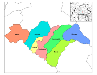
Kayao is a department or commune of Bazèga Province in central Burkina Faso. Its capital lies at the town of Kayao. According to the 1996 census the department has a total population of 37,615.

Avdur is a village in the Khojavend Rayon of Azerbaijan.

Alfonsów is a village in the administrative district of Gmina Zadzim, within Poddębice County, Łódź Voivodeship, in central Poland. It lies approximately 4 kilometres (2 mi) north-west of Zadzim, 15 km (9 mi) south-west of Poddębice, and 46 km (29 mi) west of the regional capital Łódź.
Borowa is a village in the administrative district of Gmina Puławy, within Puławy County, Lublin Voivodeship, in eastern Poland. It lies approximately 17 kilometres (11 mi) north-west of Puławy and 60 km (37 mi) north-west of the regional capital Lublin.
Podlesice is a village in the administrative district of Gmina Charsznica, within Miechów County, Lesser Poland Voivodeship, in southern Poland. It lies approximately 7 kilometres (4 mi) west of Charsznica, 14 km (9 mi) west of Miechów, and 38 km (24 mi) north of the regional capital Kraków.
Jakubowice is a village in the administrative district of Gmina Ożarów, within Opatów County, Świętokrzyskie Voivodeship, in south-central Poland. It lies approximately 9 kilometres (6 mi) south of Ożarów, 18 km (11 mi) east of Opatów, and 75 km (47 mi) east of the regional capital Kielce.
Ludynia is a village in the administrative district of Gmina Krasocin, within Włoszczowa County, Świętokrzyskie Voivodeship, in south-central Poland. It lies approximately 6 kilometres (4 mi) south of Krasocin, 11 km (7 mi) east of Włoszczowa, and 36 km (22 mi) west of the regional capital Kielce.
Późna is a village in the administrative district of Gmina Gubin, within Krosno Odrzańskie County, Lubusz Voivodeship, in western Poland, close to the German border.
Prędocin is a village in the administrative district of Gmina Skarbimierz, within Brzeg County, Opole Voivodeship, in south-western Poland.
Dziechno is a village in the administrative district of Gmina Cewice, within Lębork County, Pomeranian Voivodeship, in northern Poland. It lies approximately 10 kilometres (6 mi) north-east of Cewice, 9 km (6 mi) south-east of Lębork, and 54 km (34 mi) west of the regional capital Gdańsk.
Małe Walichnowy is a village in the administrative district of Gmina Pelplin, within Tczew County, Pomeranian Voivodeship, in northern Poland. It lies approximately 10 kilometres (6 mi) east of Pelplin, 20 km (12 mi) south-east of Tczew, and 50 km (31 mi) south of the regional capital Gdańsk.
Winiec is a settlement in the administrative district of Gmina Bisztynek, within Bartoszyce County, Warmian-Masurian Voivodeship, in northern Poland.
Kąp is a village in the administrative district of Gmina Giżycko, within Giżycko County, Warmian-Masurian Voivodeship, in northern Poland.

Mardikh is a village in the Idlib Governorate of Syria. It is the nearest village to the site of historical Ebla, south east of Idlib. Nearby localities include Saraqib to the north, Kafr Amim to the east, Maardabsah and Khan al-Sabl to the south and Dadikh to the west. According to the Syria Central Bureau of Statistics (CBS), Mardikh had a population of 2,918 in the 2004 census.
Chrząstowo is a village in the administrative district of Gmina Kamień Pomorski, within Kamień County, West Pomeranian Voivodeship, in north-western Poland. It lies approximately 5 kilometres (3 mi) north-east of Kamień Pomorski and 67 km (42 mi) north of the regional capital Szczecin.
Kosobudy is a village in the administrative district of Gmina Biały Bór, within Szczecinek County, West Pomeranian Voivodeship, in north-western Poland.
Nielep is a village in the administrative district of Gmina Rąbino, within Świdwin County, West Pomeranian Voivodeship, in north-western Poland. It lies approximately 8 kilometres (5 mi) south-west of Rąbino, 8 km (5 mi) north-east of Świdwin, and 96 km (60 mi) north-east of the regional capital Szczecin.

Tú Trĩ is a commune (xã) and village in Bạch Thông District, Bắc Kạn Province, in Vietnam.


