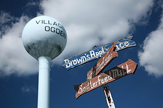
Ogden is a village in Champaign County, Illinois, United States. The population was 810 at the 2010 census.

Glenview Hills is a home rule-class city in Jefferson County, Kentucky, United States. The population was 319 at the 2010 census.

Újezd u Sezemic is a village in the Pardubice Region of the Czech Republic. It has about 110 inhabitants.

The Seputeh Komuter station is a KTM Komuter train station named after and located in Seputeh, Kuala Lumpur, along the KTM Komuter's Seremban Line.

Ilinci is a village in Serbia. It is situated in the Šid municipality, in the Srem District, Vojvodina province. The village has a Serb ethnic majority and its population numbering 827 people.

The Batang Kali Komuter station is a Malaysian commuter train station stationed at the northwest of and named after the town of Batang Kali, Hulu Selangor, Selangor. The station was opened on April 21, 2007 alongside the Rasa and Serendah stations.
The Estonian Open Air Museum is a life-sized reconstruction of an 18th-century rural/fishing village, which comes complete with church, inn, schoolhouse, several mills, a fire station, twelve farmyards and net sheds. The site spans 72 hectares of land and contains about 80 separate buildings and is located 8 km to the west of Tallinn city center at Rocca al Mare. Established in 1957, the museum showcases 68 farmhouses assembled into twelve farmyards from North, South and West Estonia.

Strabla is a village in the administrative district of Gmina Wyszki, within Bielsk County, Podlaskie Voivodeship, in north-eastern Poland. It lies approximately 17 kilometres (11 mi) north of Bielsk Podlaski and 24 km (15 mi) south of the regional capital Białystok.
Nacław is a village in the administrative district of Gmina Kościan, within Kościan County, Greater Poland Voivodeship, in west-central Poland. It lies approximately 3 kilometres (2 mi) south of Kościan and 42 km (26 mi) south-west of the regional capital Poznań.
Jaromierz is a village in the administrative district of Gmina Człuchów, within Człuchów County, Pomeranian Voivodeship, in northern Poland. It lies approximately 6 kilometres (4 mi) west of Człuchów and 120 km (75 mi) south-west of the regional capital Gdańsk.
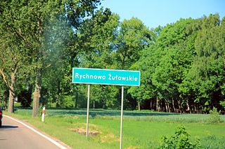
Rychnowo Żuławskie is a village in the administrative district of Gmina Nowy Dwór Gdański, within Nowy Dwór Gdański County, Pomeranian Voivodeship, in northern Poland. It lies approximately 4 kilometres (2 mi) south of Nowy Dwór Gdański and 38 km (24 mi) south-east of the regional capital Gdańsk.
Wrzeście is a village in the administrative district of Gmina Słupsk, within Słupsk County, Pomeranian Voivodeship, in northern Poland. It lies approximately 11 kilometres (7 mi) north-east of Słupsk and 101 km (63 mi) west of the regional capital Gdańsk.
Klarewo is a village in the administrative district of Gmina Biała Piska, within Pisz County, Warmian-Masurian Voivodeship, in northern Poland.

Ostrowice is a village in Drawsko County, West Pomeranian Voivodeship, in north-western Poland. Until January 1, 2019, it was the seat of the gmina called Gmina Ostrowice that was created after the Second World War but divided on January 1, 2019, between the administrative districts of Zlocieniec and Drawsko Pomorskie because of high debts. It lies approximately 17 kilometres (11 mi) north-east of Drawsko Pomorskie and 96 km (60 mi) east of the regional capital Szczecin.

Nový Dvůr is a village and municipality in Nymburk District in the Central Bohemian Region of the Czech Republic.

Risserkogel is a mountain of Bavaria, Germany.

The Hachinger Bach is a river in Bavaria, Germany. It flows southwards of Munich, through the townships of Oberhaching, Taufkirchen, Unterhaching and Unterbiberg, and enters the Munich city area in Perlach. It is twelve kilometers long.
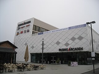
The Pasing Arcaden is a shopping mall located in Munich's district of Pasing. The first section of the Pasing Arcaden was opened on the 15 of March 2011. It is located near the Pasing train station, in the west of Munich.

Neuperlach is a borough in the south-east of the Bavarian capital Munich and is part of the city district no. 16, Ramersdorf-Perlach. It was built starting in 1967 east of the former village of Perlach on the ground of the former Perlacher Haid. Neuperlach is located east of the boroughs Ramersdorf and Perlach, south of the city districts no. 14 and no. 15 (Trudering-Riem), west of the borough Waldperlach and north of Unterbiberg. The borough encompasses multiplehousing estates, including several high-rise estates, and is one of Germany's biggest satellite towns. In the center of Neuperlach the large pep shopping mall is located, one of the most profitable shopping centers in Germany. The Hachinger Bach runs through the western part of Neuperlach from north to south. The stream also passes through the western part of the Ostpark.

Ramersdorf-Perlach is a borough of Munich. It is located south-east of the city center and is the most populous of Munich's boroughs with a population of about 116,000.


