Ostweg

Last updated
Ostweg
Wartenberg2.png
Wartenberg
Lengthc. 240 km
LocationGermany,
Baden-Württemberg,
Black Forest
Trailheads Pforzheim; Schaffhausen
Use long distance path
Elevation
Elevation change 648 m
Highest pointnear Hondingen (921 m)
Lowest point Pforzheim (273 m)
Hiking details
Seasonspring to autumn
Waymark black and red vertically divided diamond on a white background
Wegzeichen Ostweg.svg
Sights Zavelstein Castle, Wanne, Randen
Maintained by Black Forest Club


The Ostweg is a north-south long-distance path through the Black Forest from Pforzheim to Schaffhausen. The roughly 240-kilometre-long ridgeway was laid out in 1903 and has been managed and maintained since then by the Black Forest Club. Its waymark is a black and red diamond on a white background.

Black Forest mountain range in Baden-Württemberg, southwestern Germany

The Black Forest is a large, forested mountain range in the state of Baden-Württemberg in southwest Germany. It is bounded by the Rhine valley to the west and south. Its highest peak is the Feldberg with an elevation of 1,493 metres (4,898 ft). The region is roughly oblong in shape with a length of 160 km (99 mi) and breadth of up to 50 km (31 mi).

Pforzheim Place in Baden-Württemberg, Germany

Pforzheim is a city of over 120,000 inhabitants in the federal state of Baden-Württemberg, in the southwest of Germany. It is known for its jewelry and watch-making industry, and as such has gained the nickname "Goldstadt". With an area of 97.8 km2 (38 sq mi), it is situated between the cities of Stuttgart and Karlsruhe at the confluence of three rivers. It marks the frontier between Baden and Württemberg, being located on Baden territory. From 1535 to 1565, it was the home to the Margraves of Baden-Pforzheim.

Schaffhausen Place in Switzerland

Schaffhausen is a town with historic roots, a municipality in northern Switzerland, and the capital of the canton of the same name; it has an estimated population of 36,000 as of December 2016. It is located right next to the shore of the High Rhine; it is one of four Swiss towns located on the northern side of the Rhine, along with Neuhausen a. Rhf., the historic Neunkirch, and Stein a. Rh..

Contents

Day tours/stages

First stage: Pforzheim – Bad Liebenzell

Overview

  • Distance: 25 km
  • Journey time: c. 6 hours
Place/AttractionRoute
(km)
Höhe
(m ü.  NHN)
Further information
Pforzheim-Kupferhammer0254Starting point of the three Black Forest ridgeways: the Westweg (Pforzheim – Basel), Mittelweg (Pforzheim – Waldshut) and Ostweg (Pforzheim – Schaffhausen)
Pforzheim-Würm4.0327
Liebeneck Castle 3.0340
Hamberg4.0484In the municipality of Neuhausen
Steinegg Castle 1.5391
Neuhausen 4.5482
Monbachbrückle1.5450Entry to the Monbach valley
Bad Liebenzell 6.5333

Route description

The starting point is the Kupferhammer south of Pforzheim. The path runs initially parallel to the road into the Würm valley and then climbs up to the right through the Pforzheim district of Würm and back down to the valley again. At a forest car park the path crosses a wooden bridge and continues to the ruins of Liebeneck. Carrying on up the Würm valley it reaches Hamberg, leaving it on the Schlossstraße. After a chapel it runs past the ruins of Steinegg to Neuhausen. Next the walk crosses the little bridge of Monbachbrückle into the Monbach valley. The Monbach empties into the River Nagold. At their confluence the path turns right and runs parallel to the railway line to Bad Liebenzell.

Würm (Nagold) river

The Würm is a river of Baden-Württemberg, southwestern Germany. It is a right tributary of the river Nagold, south of Pforzheim, only 2 kilometers before the Nagold discharges into the Enz.

Second stage: Bad Liebenzell – Oberhaugstett

Overview

  • Distance: 21 km
  • Journey time: c. 5 hours
Place/AttractionRoute
(km)
Höhe
(m ü. NHN)
Further information
Bad Liebenzell 0333
Wolfsschlucht3.0380near Ernstmühl
Hirsau 2.0341In the municipality of Calw
Abbey Ruins of
Calw 3.5347
Zavelstein 6.0585In the municipality of Bad Teinach-Zavelstein

Castle ruins and viewing tower

Bad Teinach1.0391In the municipality of Bad Teinach-Zavelstein
Liebelsberg3.0614In the municipality of Neubulach
Oberhaugstett2.5569In the municipality of Neubulach

Route description

Ruins of Hirsau Abbey Torturm und Jagdschloss Kloster Hirsau.jpg
Ruins of Hirsau Abbey

After leaving the outskirts of Bad Liebenzell the path leads to the Wolfsschlucht gorge near Ernstmühl and then to the village of Hirsau with its ruined abbey dating to the 11th century. Calw itself is then reached via the Hirsauer Wiesenweg. Along Inselgasse and Lederstraße the path continues via the market place (Marktplatz) and Salzgasse out of the town to the rock massif of Gimbelstein and on to the Zavelstein Hostel which lies next to the Zavelsteiner Krokuswiesen Nature Reserve, In Zavelstein the route continues along Staufer Straße and Krokusstraße to the castle. Then the walk descends steeply to Bad Teinach. At the church the path turns right into Badstraße, goes past the Kurhaus and through the spa grounds uphill to Liebelsberg. Just before the village there is a water tower, which is also used as a viewing tower. From Liebelsberg a tarmac path leads to Oberhaugstett, which is reached along the road called Am Schleifberg.

Hirsau Abbey former Benedictine abbey in Calw

Hirsau Abbey, formerly known as Hirschau Abbey, was once one of the most important Benedictine abbeys of Germany. It is located in the Hirsau borough of Calw on the northern slopes of the Black Forest mountain range, in the present-day state of Baden-Württemberg. In the 11th and 12th century, the monastery was a centre of the Cluniac Reforms, implemented as "Hirsau Reforms" in the German lands. The complex was devastated during the War of the Palatine Succession in 1692 and not rebuilt.

Third stage: Oberhaugstett – Pfalzgrafenweiler

Overview

  • Distance: 22 km
  • Journey time: c. 5.5 hours
Place/AttractionRoute
(km)
Höhe
(m ü. NHN)
Further information
Oberhaugstett0569
Buhlerwaldstern4.0618
Wart 1.5600In the municipality of Altensteig
Berneck3.5455In the municipality of Altensteig
Altensteigdorf1.5558In the municipality of Altensteig
Altensteig 1.5444
Kohlsägmühle3.5470
Zinsbachmühle3.5530
Büchelesbrunnen1.0630
Pfalzgrafenweiler 2.0636Intersection with the Gäurandweg

Route description

We leave Oberhaugstett on Martinsmooser Straße; the path goes past the watchtower (Wart) to the castle and village of Berneck. Other destinations are Altensteigdorf, Altensteig, the Kohlsägmühle mill, the Zinsbachmühle mill and the end of the stage at Pfalzgrafenweiler.

Fourth stage: Pfalzgrafenweiler – Freudenstadt

Overview

  • Distance: 18.5 km
  • Journey time: c. 4.5 hours
Place/AttractionRoute
(km)
Höhe
(m ü. NHN)
Further information
Pfalzgrafenweiler 0636
Russenbusch0.5650
Findelhütte3.0659
Fuchstrieb1.0713
Hausers Heuscheuer1.5693
Beim Glattbächle0.5695
Obermusbach2.0660In the municipality of Freudenstadt
Untermusbach1.5680In the municipality of Freudenstadt
Tal des Aunbachs1.0632In the municipality of Freudenstadt
Frutenhof 1.0670In the municipality of Freudenstadt
Haldenberg2.5670Sportplatz Wittlensweiler
Freudenstadt 2.5728Joins the Mittelweg from Pforzheim–Waldshut

Route description

We leave Pfalzgrafenweiler on Christoph-Decker-Straße. After 9 kilometres the path reaches Obermusbach. There the walk continues along Kälberbronner Straße, Klosterstraße and Mühlhaldenstraße to Untermusbach. Here it continues along Mühlhaldenstraße, past the sports field, along Merzenbergstraße and Müllerstraße out of the village. Passing Frutenhof and Wittlensweiler it leads to Freudenstadt. In the town the route passes the cemetery and reaches the railway station. It then goes along Musbacher Straße and Stuttgarter Straße to the market place (Marktplatz).

Fifth stage: Freudenstadt – Alpirsbach

Overview

  • Distance: 21.5 km
  • Journey time: c. 5 hours
Place/AttractionRoute
(km)
Höhe
(m ü. NHN)
Further information
Freudenstadt 0728
Friedrichsturm / Kienberg1.5799
Kohlberg4.5730
Vogteiturm1.0740viewing tower
Sandwiese1.0752
Adrionshof1.0724
Schömberg 3.5744In the municipality of Loßburg
Alpirsbach 9.0441End point of the Querwegs Gengenbach–Alpirsbach

Route description

After the market place the route continues through Freudenstadt along Loßburger Straße, Straßburger Straße, Lauterbadstraße, Friedrich-Ebert-Straße and Herzog-Friedrich-Straße to the Friedrichsturm tower on the Kienberg. The route then runs past the Vogtei Tower to the Adrionshof and on to Ödenwald. About 2 kilometres further on it reaches a large forest clearing. It continues along the edge of the wood and the road to Schömberg, leaving via Reinerzauerstraße and Altenburgstraße. After 2 kilometres the route leaves the track in the forest district of Hardt and follows a narrow footpath. After the Heilenberger Hut it continues, in places very steeply, down to Alpirsbach, which is reached via Forchenweg.

Sixth stage: Alpirsbach – Schramberg

Overview

  • Distance: 19 km
  • Journey time: c. 5.5 hours
Place/AttractionRoute
(km)
Höhe
(m ü. NHN)
Further information
Alpirsbach 0441
Rötenbach1.5420In the municipality of Alpirsbach
Adelsberg1.0518
Fräulinsberg2.0530
Holzebene3.0583 Naturfreundehaus
Brandsteig-Schänzle1.5690Römische Straßenstation
Zollhaus1.5720
Aichhalden 2.5716
Paradieshof3.5670
Schramberg 2.5424

Seventh stage: Schramberg – Villingen

Overview

  • Distance: 27.5 km
  • Journey time: c. 7 hours
Place/AttractionRoute
(km)
Höhe
(m ü. NHN)
Further information
Schramberg 0424
Tischneck2.5720In the municipality of Schramberg
Benediktinerhöhe1.0798
Hardt 1.5800
Mönchhof2.0794
Lindenloch / Glasbachtal2.0760
Albblick / Martinsweiler1.5770Kreuzung mit dem Querweg Rottweil–Lahr
Ruine Waldau 1.5737Kulturdenkmal Hof Beck
Königsfeld 2.0761Kreuzung mit Querweg Rottweil–Lahr
Mönchweiler 5.5801
Kurgarten Villingen5.5721Kreuzung mit dem Black Forest-Jura-Bodensee-Weg
Villingen 2.5704

Eighth stage: Villingen – Sunthausen

Overview

  • Distance: 16.5 km
  • Journey time: c. 4 hours
Place/AttractionRoute
(km)
Höhe
(m ü. NHN)
Further information
Villingen 0704
viewing tower Wanne 2.5777
Bertholdshöfe1.0758Intersection with the Black Forest Jura-Bodensee-Weg
Hölzlekönig 1.0748Ehemaliges Naturdenkmal
Kugelmoos2.5710
Schwenninger Moos 1.0706 Naturschutzgebiet
Bad Dürrheim-Kurhaus Hüttenbühl2.0700
Waldcafé2.0795Aussichtspunkt
Hirschhaldehütte2.0759Kleine Schutzhütte
Sunthauser See 2.0707
Sunthausen 0.5706In the municipality of Bad Dürrheim

Ninth stage: Sunthausen – Geisingen

Overview

  • Distance: 16 km
  • Journey time: c. 4 hours
Place/AttractionRoute
(km)
Höhe
(m ü. NHN)
Further information
Sunthausen0706
Öfingen 5.0820In the municipality of Bad Dürrheim
Intersection with the Black Forest Jura-Bodensee-Weg
Blatthaldenhütte5.0915Schutzhütte mit Grillplatz
Aussichtspunkt
Hörnlekapf1.5875Hubertushütte
Aussichtspunkt
Geisingen 4.5667

Tenth stage: Geisingen – Achdorf

Overview

  • Distance: 23 km
  • Journey time: c. 6 hours
Place/AttractionRoute
(km)
Höhe
(m ü. NHN)
Further information
Geisingen 0667
Wartenberg 2.0825
Gutmadingen 2.5673In the municipality of Geisingen
Wendthütte3.0859Grillplatz
Längewiesen1.5914
Wegabzweigung nach Hondingen0.5921Höchster Punkt des Ostwegs
Neue Hütte1.5835
Hondingen1.5720In the municipality of Blumberg
Eichberg6.0913Schutzhütte
Aussichtspunkt
Achdorf4.5540In the municipality of Blumberg

Eleventh stage: Achdorf – Stühlingen

Overview

  • Distance: 16.5 km
  • Journey time: c. 4.5 hours
Place/AttractionRoute
(km)
Höhe
(m ü. NHN)
Further information
Achdorf0540Kreuzung mit dem Querweg Freiburg–Bodensee
Kreuzung mit dem Schluchtensteig
Wutachflühen Bei der Muttergottes4.0575Naturschutzgebiet
Kreuzung mit dem Schluchtensteig
Footbridge over the Wutach 2.5505Flüheweg durch das Wutachtal
Gasthaus Wutachschlucht1.5500Ehemaliger Haltepunkt Lausheim-Blumegg der stillgelegten Wutachtalbahn (Sauschwänzlebahn)
Ehemaliger Bahnhof Weizen4.0471Bahnhof der stillgelegten Wutachtalbahn (Sauschwänzlebahn)
Kreuzung mit dem Schluchtensteig
Katzenloch1.0530
Stühlingen 3.5501Kreuzung mit dem Schluchtensteig

Twelfth stage: Stühlingen – Schaffhausen

Overview

  • Distance: 19 km
  • Journey time: c. 5 hours
Place/AttractionRoute
(km)
Höhe
(m ü. NHN)
Further information
Stühlingen 0501
Stühlingen-Grenzübergang1.0450
Schleitheim 2.5467
Strickhof2.5580
Schleitheimer Schlossranden 2.0901 Schleitheimer Randenturm
Zelgli1.0865
Bräunlingsbuck2.5778
Chlosterfeld2.0655
Schaffhausen 5.5400

Route description

Schleitheim Picswiss SH-04-01.jpg
Schleitheim

The route leaves Stühlingen via Hauptstraße and Bahnhofstraße.

Literature

Reinhard Distel und Heinz R. Wittner: Wanderführer Schwarzwald-Höhenwege. 7th edn., Ostfildern, 1997. ISBN   3-8134-0213-4. pp. 111–141

International Standard Book Number Unique numeric book identifier

The International Standard Book Number (ISBN) is a numeric commercial book identifier which is intended to be unique. Publishers purchase ISBNs from an affiliate of the International ISBN Agency.

Related Research Articles

Hunter Mountain (New York) Highest mountain in Greene County, New York, and second highest in the Catskills

Hunter Mountain is in the towns of Hunter and Lexington, just south of the village of Hunter, in Greene County, New York, United States. At approximately 4,040 feet (1,231 m) in elevation, it is the highest peak in the county and the second-highest peak in the Catskill Mountains.

Schömberg, Calw Place in Baden-Württemberg, Germany

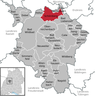
Schömberg is a spa town in the north of the Black Forest in Baden-Württemberg.

Bad Liebenzell Place in Baden-Württemberg, Germany

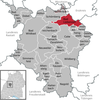
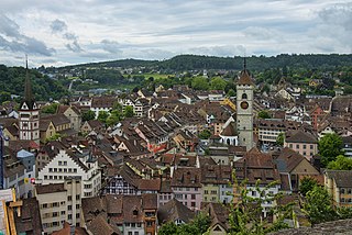
Bad Liebenzell is a spa town in the Nagold River valley, the northern part of the Black Forest. It was first mentioned in 1090 and is the heart of the Liebenzeller Mission.

Kinzig (Rhine) river in Germany

The Kinzig is a river in southwestern Germany, a right tributary of the Rhine.

E1 European long distance path walking path

The E1 European long-distance path, or just E1 path, is one of the European long-distance paths designated by the European Ramblers' Association. It has a total length of some 4,960 miles (7,980 km). It begins in Norway at Nordkapp, and crosses the Kattegat between Sweden and Denmark by ferry. It passes through Denmark, Germany, and Switzerland to finish at Scapoli, Italy. This path was extended southwards to Sicily, in Italy in 2018.

Westweg

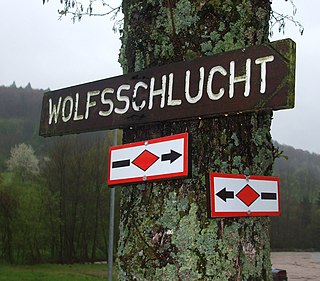
The Westweg is a long-distance hiking trail in Germany, running north-south through the Black Forest from Pforzheim to Basel. The trail is around 285 km long, and was founded in 1900. It is currently maintained under the auspices of the Black Forest Club. The trail symbol is a red lozenge on a white background. The Westweg is a part of the European Long-distance Trail E1 The route passes through or near numerous villages or small towns, so there is no difficulty in finding overnight accommodation and meals along the route. It would actually require more planning to walk it while staying in youth hostel-type accommodation, or camping. There are a number of services that will transport your luggage to the next accommodation by vehicle, leaving the hikers with only their daypacks for the hike. The route can be accessed at several places along its length by road or public transport, so it is easy to walk part of it or to do day walks along its route.

Nagold Valley Railway railway line

The Nagold Valley Railway is a railway line in the northern part of the Black Forest in Germany which links Pforzheim with Horb am Neckar and, for most of its route, follows the valley of the River Nagold.

Bertha Benz Memorial Route scenic route

The Bertha Benz Memorial Route is a German tourist and theme route in Baden-Württemberg and member of the European Route of Industrial Heritage. It opened in 2008 and follows the tracks of the world's first long distance road trip by a vehicle powered with an internal combustion engine, in 1888.

Kniebis mountain

The Kniebis is a 960-metre-high mountain ridge in the Black Forest and the name of a village to the south which is a dispersed settlement. The Kniebis mountain rises in the state of Baden-Württemberg, Germany.

Eutingen im Gäu–Freudenstadt railway railway line

The Eutingen im Gäu–Freudenstadt railway is a railway line in the German state of Baden-Württemberg that runs from the cultural landscape of the Gäu to the eastern edge of the Black Forest, connecting Eutingen and Freudenstadt. It is a section of the Gäu Railway from Stuttgart to Freudenstadt opened on 1 September 1879.

Nagold (river) river in Germany

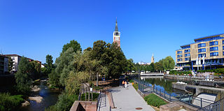
The Nagold is a river, 91 kilometres long, in Baden-Württemberg, southwestern Germany. A tributary of the Enz, it gave its name to the town of Nagold. It merges with the smaller Enz in the town centre of Pforzheim.

East Highland Way long-distance trail in Highland, Scotland, UK

The East Highland Way is a long distance walking route in Scotland that connects Fort William (56.8178°N 5.1109°W) with the ski and mountain resort of Aviemore (57.1899°N 3.8292°W). The route was described by the architect Kevin Langan in 2007. The name is derived from the fact that the route terminates in Aviemore at the eastern edge of Highland region. The EHW route takes in a varied and wild landscape through deep forest plantations, passing many highland lochs and negotiating unspoilt marshlands. The route also explores the ancient Caledonian forests of Inshriach. The walk is 82 miles (132 km) long.

Walking routes in the Palatine Forest

Walking routes in the Palatine Forest fall into two categories. The first are longer walking routes, most of which are maintained by the Palatine Forest Club, or PWV, and which are linked to the national and international network of long distance paths. The second category are those local circular walks and themed walking routes, some of which are of wider regional importance, and which are maintained by municipal authorities. The Palatine Forest, as part of the Palatine Forest-North Vosges Biosphere Reserve, is an important conservation area. As a result, the Palatine Forest, the bunter sandstone landscape of the Palatine Forest Nature Park, the castles in the Dahner Felsenland and the cross-border paths into Alsace and the Vosges make the region particularly popular with ramblers and walkers.

Birkenhainer Straße

The Birkenhainer Straße is a long-distance hiking trail that follows an ancient trade route through the Mittelgebirge Spessart, in the states of Hesse and Bavaria, Germany. It is 71 km long and leads from Hanau to Gemünden am Main, cutting across the so-called Mainviereck, a large loop of the river Main. The trail follows an ancient trade route which in the Middle Ages was an important road for moving troops and for long-distance trade. The Birkenhainer Straße was a part of the link between Nuremberg and Antwerp. Its origins may lie back as far as the Neolithic period. The name likely derives from a prominent copse of birch trees that used to exist near the road at Geiselbach (Hesse).

<i>Mittelweg</i>

The Mittelweg is a north-south long-distance path which runs through the Black Forest from Pforzheim to Waldshut. It is about 230 kilometres long and was established in 1903. Since then it has been maintained and sponsored by the Black Forest Club. Its waymark is a red diamond with a white bar on a white background.

Gengenbach–Alpirsbach Black Forest Trail

The Gengenbach–Alpirsbach Black Forest Trail is a long distance path through the Central Black Forest in Germany. The 51-kilometre-long east-west route is sponsored and maintained by the Black Forest Club. Its waymark is a blue diamond on a yellow background.


The Black Forest North Perimeter Way is a 55-kilometre-long hiking trail in three stages running from Mühlacker to Karlsruhe-Durlach in Germany.

Kaiserstuhl–Rhine Black Forest Trail

The Kaiserstuhl–Rhine Black Forest Trail is an east-west hiking trail of several days duration through the Black Forest in Germany from Donaueschingen to Breisach. The 109-kilometre-long hiking trail is managed and maintained by the Black Forest Club.

The Gäu Perimeter Way is a hiking trail in the Northern Black Forest in Germany and the easternmost of the long distance paths managed by the Black Forest Club. With a length of 120 kilometres, it runs in six stages from Mühlacker to Freudenstadt.