Ouahigouya

Last updated
Ouahigouya
Ouahigouya road.jpg
Burkina Faso location map.svg
Red pog.svg
Ouahigouya
Location within Burkina Faso, French West Africa
Coordinates: 13°35′N2°25′W / 13.583°N 2.417°W / 13.583; -2.417
CountryFlag of Burkina Faso.svg  Burkina Faso
Region Nord Region
Province Yatenga Province
Founded1757
Elevation
315 m (1,033 ft)
Population
 (2019 census) [1]
  Total124,587
Time zone UTC+0 (GMT)

Ouahigouya is a town in northern Burkina Faso, situated 182 kilometres northwest of Ouagadougou. It is the capital of the Yatenga Province and one of its subdivisions the Ouahigouya Department. It is also the biggest town in the Nord Region and the fourth largest city in the country with a population of 124,587 (2019) [1]

Contents

View of Ouahigouya (2005) Ouahigouya BurkinaFaso.JPG
View of Ouahigouya (2005)

The city itself has a stadium, a private non-profit Paediatric Hospital with 36 beds for giving birth and 24 beds for children suffering of severe malnutrition, a post office with internet access and at least one Ecobank bank branch.

History

The city was founded in 1757 as the capital of Yatenga one of a number of Mossi Kingdoms. The city still bears testimony to its role as capital of the Yatenga Kingdom in its name, the meaning of which is come and prostrate yourselves.

In the Christmas War of 1985, the city's marketplace was bombed by Malian forces, almost 100 people being killed.

Economy

Mainly of an agriculturally based economy, Ouahigouya also has some commerce and craft industry. The two dams just north and west of the town permit it to pursue some vegetable planting aided by irrigation, such as tomatoes, carrots, onions and mainly potatoes. But as a whole both the region and the city are heavily dependent on rainfall and it is according to it that the population's well-being mostly depends on. Millet and sorghum though are the basis of the local diet, much like the surrounding regions.

The small craft industry here is mainly focused on leather and tanneries. The little industry in the region is mostly geared towards gold prospecting, and is carried out by a large company. In terms of commerce, the city takes advantage of its relative ease of access to the country's capital, Ouagadougou, to buy manufactured products and resell to the local economy. This is greatly facilitated by the asphalted road linking the two cities.

Places of interest

Features of Ouahigouya include Naaba Kango's tomb, the Yatenga Naba's compound and an artificial lake.

Geography

Climate

Classified by Köppen-Geiger system as hot semi-arid (BSh).

Climate data for Ouahigouya (1991–2020, extremes 1920–present)
MonthJanFebMarAprMayJunJulAugSepOctNovDecYear
Record high °C (°F)40.0
(104.0)
42.5
(108.5)
44.3
(111.7)
45.5
(113.9)
48.8
(119.8)
48.0
(118.4)
40.8
(105.4)
38.6
(101.5)
41.3
(106.3)
41.8
(107.2)
40.6
(105.1)
43.6
(110.5)
48.8
(119.8)
Mean daily maximum °C (°F)32.3
(90.1)
35.6
(96.1)
39.0
(102.2)
40.8
(105.4)
40.0
(104.0)
37.0
(98.6)
33.7
(92.7)
31.8
(89.2)
33.5
(92.3)
37.0
(98.6)
36.8
(98.2)
33.6
(92.5)
35.9
(96.6)
Daily mean °C (°F)24.6
(76.3)
27.7
(81.9)
31.5
(88.7)
33.9
(93.0)
33.5
(92.3)
31.1
(88.0)
28.3
(82.9)
26.8
(80.2)
27.8
(82.0)
29.9
(85.8)
28.6
(83.5)
25.6
(78.1)
29.1
(84.4)
Mean daily minimum °C (°F)17.7
(63.9)
20.4
(68.7)
24.4
(75.9)
27.5
(81.5)
28.0
(82.4)
26.0
(78.8)
23.9
(75.0)
23.0
(73.4)
23.4
(74.1)
24.1
(75.4)
21.3
(70.3)
18.4
(65.1)
23.2
(73.7)
Record low °C (°F)8.5
(47.3)
11.2
(52.2)
13.1
(55.6)
13.5
(56.3)
17.0
(62.6)
15.7
(60.3)
17.9
(64.2)
18.6
(65.5)
18.1
(64.6)
16.2
(61.2)
11.2
(52.2)
10.0
(50.0)
8.5
(47.3)
Average precipitation mm (inches)0.1
(0.00)
0.1
(0.00)
1.3
(0.05)
7.1
(0.28)
39.6
(1.56)
107.0
(4.21)
170.4
(6.71)
238.9
(9.41)
130.4
(5.13)
38.8
(1.53)
1.1
(0.04)
0.7
(0.03)
734.8
(28.93)
Average precipitation days (≥ 1.0 mm)0.00.10.21.13.67.110.913.19.13.50.10.048.8
Average relative humidity (%)26222635526473807762402949
Mean monthly sunshine hours 276.5259.1266.3249.4265.9246.6246.5226.4246.1280.2285.0284.73,132.7
Source 1: World Meteorological Organization, [2] Meteo Climat (record highs and lows) [3]
Source 2: Deutscher Wetterdienst (humidity, 1951–1967) [4] [5] [lower-alpha 1]

Sister Cities

Ouahigouya has one sister city: [6]

See also

Notes

  1. Station ID for Ouahigouya is 65502 Use this station ID to locate the sunshine duration

Related Research Articles

<span class="mw-page-title-main">Geography of Burkina Faso</span> Landlocked Sahel country that shares borders with six nations

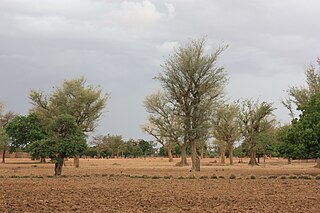
Burkina Faso is a landlocked Sahel country that shares borders with six nations. It lies between the Sahara desert and the Gulf of Guinea, south of the loop of the Niger River, mostly between latitudes 9° and 15°N, and longitudes 6°W and 3°E. The land is green in the south, with forests and fruit trees, and semi-arid in the north. Most of central Burkina Faso lies on a savanna plateau, 198–305 metres (650–1,001 ft) above sea level, with fields, brush, and scattered trees. Burkina Faso's game preserves – the most important of which are Arly, Nazinga, and W National Park—contain lions, elephants, hippopotamus, monkeys, common warthogs, and antelopes. Previously the endangered painted hunting dog, Lycaon pictus occurred in Burkina Faso, but, although the last sightings were made in Arli National Park, the species is considered extirpated from Burkina Faso.

<span class="mw-page-title-main">Ouagadougou</span> Capital of Burkina Faso

Ouagadougou or Wagadugu is the capital of Burkina Faso, and the administrative, communications, cultural and economic centre of the nation. It is also the country's largest city, with a population of 2,415,266 in 2019. The city's name is often shortened to Ouaga. The inhabitants are called ouagalais. The spelling of the name Ouagadougou is derived from the French orthography common in former French African colonies.

<span class="mw-page-title-main">Bobo-Dioulasso</span> City in Houet Province, Burkina Faso

Bobo-Dioulasso is a city in Burkina Faso with a population of 1,129,000 ; it is the second-largest city in the country, after Ouagadougou, Burkina Faso's capital. The name means "home of the Bobo-Dioula".

<span class="mw-page-title-main">Sokodé</span> Place in Centrale Region, Togo

Sokodé is the second largest city in Togo, with a population of about 189,000. It is a commercial center for the surrounding agricultural areas, and seat of the Tchaoudjo Prefecture and Centrale Region. It is in the center of the country, 339 kilometres (211 mi) north of Lomé, between the Mo and Mono rivers. It is a multi-ethnic and multi-religious city, but is dominated by Islam. The ethnic majority are Kotokolis, who live alongside Muslims.

<span class="mw-page-title-main">Koudougou</span> City in the Centre-Ouest Region, Burkina Faso

Koudougou is a city in Burkina Faso's Boulkiemdé Province. It is located 75 kilometres (47 mi) west of Ouagadougou, the capital of Burkina Faso. With a population of 160,239 (2019), it is the third most populous city in Burkina Faso after Ouagadougou and Bobo Dioulasso, and is mainly inhabited by the Gurunsi and Mossi ethnic groups. Koudougou is situated on the only railway line in Burkina Faso and has some small industries, a market, a university and provincial government offices.

<span class="mw-page-title-main">Fada N'gourma</span> City in Est Region, Burkina Faso

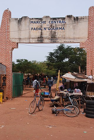
Fada N'gourma, also written Fada-Ngourma or Noungu, is a city and an important market town in eastern Burkina Faso, lying 219 kilometres (136 mi) east of Ouagadougou, in the Gourmantché area. It is the capital of the Est Region and Gourma Province, and is also the seat of the king of the Gurma and the Roman Catholic Diocese of Fada N'Gourma.

<span class="mw-page-title-main">Kaya, Burkina Faso</span> Regional capital in Centre-Nord, Burkina Faso

Kaya is the fifth largest city in Burkina Faso, lying northeast of Ouagadougou, to which it is connected by railway. It is a centre for weaving and tanning.

<span class="mw-page-title-main">Pô</span> Place in Burkina Faso

is a city in southern Burkina Faso. It is the capital of the province of Nahouri. The main ethnic group is the Kasséna, a group close to the Gurunsi. It is said to have been founded in around 1500 and is home to an army base, including the Académie militaire Georges Namoano.

<span class="mw-page-title-main">Banfora</span> City in the Cascades Region, Burkina Faso

Banfora is a city in southwestern Burkina Faso, with a population of 117,452 making it the sixth most populous city in Burkina Faso. It is the capital of the Comoe province. The city lies 85 kilometres (53 mi) south-west of Bobo-Dioulasso, on the Abidjan – Ouagadougou Railway. The Cascades de Karfiguéla are a series of waterfalls close to Banfora.

<span class="mw-page-title-main">Yatenga Province</span> Province in Nord Region, Burkina Faso

Yatenga is one of the provinces of Burkina Faso, located in the Nord Region of the country. In modern Yatenga, the most prominent city is Ouahigouya. This city served as the capital of the kingdom of Yatenga, a powerful kingdom out of the many Mossi kingdoms, but its influence decreased in the century following French colonisation. The city is famed today for being home to the Naba's compound and the tomb of Naba Kango.

<span class="mw-page-title-main">Nord Region (Burkina Faso)</span> Region of Burkina Faso

Nord is one of Burkina Faso's 13 administrative regions. It was created on 2 July 2001. The population of Nord was 1,720,908 in 2019. The region's capital is Ouahigouya. Four provinces make up the region—Loroum, Passoré, Yatenga, and Zondoma.

<span class="mw-page-title-main">Mossi Kingdoms</span> Historical kingdoms in modern-day Burkina Faso

The Mossi Kingdoms, sometimes referred to as the Mossi Empire, were a group of powerful kingdoms in modern-day Burkina Faso which dominated the region of the upper Volta river for hundreds of years. The largest Mossi kingdoms was that of Ouagadougou and the king of Ouagadougou known as the Mogho Naaba, or King of All the World, serves as the Emperor of all the Mossi. The first kingdom was founded when Dagomba warriors from the region that is present-day Ghana and Mandé warriors moved into the area and intermarried with local people. Centralization of the political and military powers of the kingdoms begin in the 13th century and led to conflicts between the Mossi kingdoms and many of the other powerful states in the region. In 1896, the French took over the kingdoms and created the French Upper Volta which largely used the Mossi administrative structure for many decades in governing the colony.

Articles related to Burkina Faso include:

Rollo is a small town of 7783 people and the capital of Rollo Department, Bam Province, Burkina Faso, West Africa. The Department of Rollo has 25,000 adults, and in 2007, as part of national political decentralisation, Issa Ouermi was elected mayor of Rollo Department.

<span class="mw-page-title-main">Ouahigouya Department</span> Department in Yatenga Province, Burkina Faso

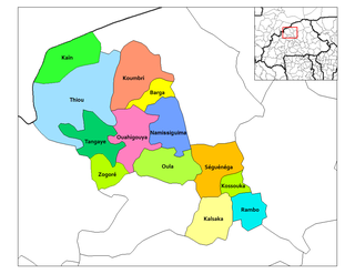
Ouahigouya is a department or commune of Yatenga Province in northern Burkina Faso. Its capital is the town of Ouahigouya. The department is coloured pink towards the centre of the Yatenga Province map, on the map just to one's right.

<span class="mw-page-title-main">Séguénéga Department</span> Department in Yatenga Province, Burkina Faso

Séguénéga is a department or commune of Yatenga Province in northern Burkina Faso. Its capital lies at the town of Ouahigouya.

<span class="mw-page-title-main">Wobgho</span>

Wobogo was the Mogho Naba (ruler) of Ouagadougou from 1890 to 1897, at the time of the French colonial conquest of Upper Volta. Wobogu was originally called Boukary Koutou, but dropped those names on his accession and assumed the name "Wobogu", meaning elephant.

<span class="mw-page-title-main">West Sudanian savanna</span> Tropical savanna ecoregion across Western Africa

The West Sudanian savanna is a tropical savanna ecoregion that extends across West Africa.

References

  1. 1 2 Citypopulation.de Population of the major cities in Burkina Faso
  2. "World Meteorological Organization Climate Normals for 1991-2020 — Fada N'gourma". National Oceanic and Atmospheric Administration. Retrieved January 4, 2024.
  3. "Station Ouahigouya" (in French). Meteo Climat. Retrieved 13 June 2016.
  4. "Klimatafel von Ouahigouya / Burkina Faso (Obervolta)" (PDF). Baseline climate means (1961-1990) from stations all over the world (in German). Deutscher Wetterdienst. Retrieved 13 June 2016.
  5. "Station 65502: Ouahigouya". Global station data 1961–1990—Sunshine Duration. Deutscher Wetterdienst. Archived from the original on 2017-10-17. Retrieved 13 June 2016.
  6. "Archived copy" (PDF). Archived from the original (PDF) on 2018-10-24. Retrieved 2018-10-24.{{cite web}}: CS1 maint: archived copy as title (link)

13°35′N2°25′W / 13.583°N 2.417°W / 13.583; -2.417