
Harpersfield is a town in Delaware County, New York, United States. The population was 1,577 at the 2010 census. The town is on the northern border of the county.

Hastings is a town in Oswego County, New York, United States. The population was 9,450 at the 2010 census. The town is named after Hastings Curtiss, a prominent citizen and member of the State Assembly in 1824.
Troupsburg is a town in Steuben County, New York, United States. The population was 1,126 at the 2000 census. The town is named after Robert Troup, an agent of the Pulteney Estate.

Vinton is a town in Roanoke County, Virginia, United States. The population was 8,098 at the 2010 census. Vinton is part of the Roanoke Metropolitan Statistical Area and the Roanoke Region of Virginia.
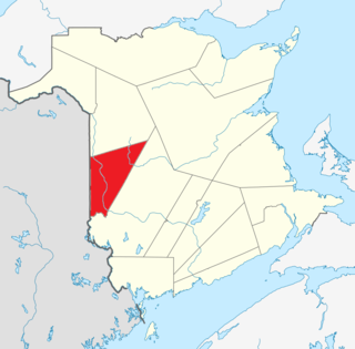
Carleton County is located in west-central New Brunswick, Canada.

Houlton is a town in Aroostook County, Maine, on the Canada–US border, located at 46.1256°N 67.8398°W. As of the 2010 census, the town's population was 6,123. It is perhaps best known for being at the northern terminus of Interstate 95 and as the birthplace of Samantha Smith, a goodwill ambassador as a child during the Cold War. The town hosts the annual Houlton Agricultural Fair.
Berwick-upon-Tweed was a local government district and borough in Northumberland in the north-east of England, on the border with Scotland. The district had a resident population of 25,949 according to the 2001 census, which also notes that it is the most ethnically homogeneous in the country, with 99.6% of the population recording themselves in the 2001 census as White. It was also the smallest district in England with borough status, and the third-least densely populated local government district.

El Porvenir is a municipio (municipality) and township in the Mexican state of Chiapas.
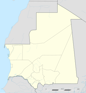
Choum is a town in northern Mauritania, lying in the Adrar Region close to the border with Western Sahara. In the year 2000, Choum had a population of 2,735.
Pleasant Bay is a bay in Washington County, Maine, at the mouth of the Pleasant River.
Cazalla de la Sierra is a small town in the province of Seville, in southern Spain. It is located in the foothills of the Sierra Norte de Sevilla, part of the Sierra Morena, which acts as a border between the region of Andalusia and the regions of Extremadura and Castilla-La Mancha.

The A156 is an 11 miles (18 km) long road that runs from the A57 near Saxilby and heads north to Gainsborough. The road runs entirely within Lincolnshire right next to the border with Nottinghamshire. It is a single carriageway for its entire length apart from one small stretch at Torksey Lock where the A1133 joins from Newark-on-Trent.
The Rural Municipality of Louise is a former rural municipality (RM) in the Canadian province of Manitoba. It was originally incorporated as a rural municipality on February 14, 1880. It ceased on January 1, 2015 as a result of its provincially mandated amalgamation with the Town of Pilot Mound and the Village of Crystal City to form the Municipality of Louise.
The United States Border Patrol operates 71 traffic checkpoints, including 33 permanent traffic checkpoints, near the Mexico–United States border. The stated primary purpose of these inspection stations is to deter illegal immigration and smuggling activities. After the September 11 attacks in 2001, they took on the additional role of terrorism deterrence. These checkpoints are located between 25 and 75 miles of the Mexico–United States border along major U.S. highways; near the southern border of the contiguous United States. Their situation at interior locations allow them to deter illegal activities that may have bypassed official border crossings along the frontier. The checkpoints are divided among nine Border Patrol sectors. There are a number of these checkpoints near the northern border of the contiguous U.S. as well ; within 100 miles (160 km) of the Canada–U.S. border.

Madarcos is a municipality of the Community of Madrid, Spain. It has an area of 8.46 km2 with a population of 49 inhabitants and a density of 5.79 inhabitants / km2 it is the people with fewer people in the Community of Madrid. It borders the municipalities of the Sierra Horcajo north and northwest; Horcajuelo of the Sierra and the Rincon Prádena east; Puentes Viejas south, and Gandullas Piñuécar- west. At its end is the desert of La Nava, in the hamlet of the same name, to the southeast of the town, on the edge of the M-137 that connects Buitrago del Lozoya with Montejo de la Sierra, past the turning Madarcos.

The Fish River is a 69.9-mile-long (112.5 km) river in northern Maine in the United States. It is a tributary of the Saint John River, which flows to the Bay of Fundy in New Brunswick, Canada.

The Clearwater River is in the northwestern United States, in north central Idaho. Its length is 74.8 miles (120.4 km), it flows westward from the Bitterroot Mountains along the Idaho-Montana border, and joins the Snake River at Lewiston. In October 1805, the Lewis and Clark Expedition descended the Clearwater River in dugout canoes, putting in at "Canoe Camp," five miles (8 km) downstream from Orofino; they reached the Columbia Bar and the Pacific Ocean about six weeks later.

Fort Fairfield is a town in Aroostook County, eastern Maine, United States, located along the Canada–US border. The population was 3,496 at the 2010 census.
Bucksport is a census-designated place (CDP) in the town of Bucksport in Hancock County, Maine, United States. The population was 2,885 at the 2010 census, down from 2,970 at the 2000 census.
