Oxenford | ||||||||||||||||
|---|---|---|---|---|---|---|---|---|---|---|---|---|---|---|---|---|
 Oxenford Railway Station and Oxenford Railway Hotel | ||||||||||||||||
| General information | ||||||||||||||||
| Location | Oxenford, Queensland Australia | |||||||||||||||
| Services | ||||||||||||||||
| ||||||||||||||||
Oxenford railway station was a railway station in Oxenford, Queensland, Australia.
Oxenford | ||||||||||||||||
|---|---|---|---|---|---|---|---|---|---|---|---|---|---|---|---|---|
| Oxenford Railway Station and Oxenford Railway Hotel | ||||||||||||||||
| General information | ||||||||||||||||
| Location | Oxenford, Queensland Australia | |||||||||||||||
| Services | ||||||||||||||||
| ||||||||||||||||
Oxenford railway station was a railway station in Oxenford, Queensland, Australia.
In January 1904, a horse broke free near the station and was killed after being carried by the engine over the railway bridge. [1]
After a requests request for a weigh bridge by the Coomera Progress Association in 1907, one was promised by the Commissioner for Railways in 1922. [2] [3]
The Goods shed was damaged by fire in August 1922. [4]
The safe was stolen in August 1937, before being found submerged in a creek at Kingston. [5] [6] A 25 year old labourer was charged and later sentenced to three years imprisonment with hard labour. [7] [8]

The Cleveland railway line is a suburban railway line extending 37.3 kilometres (23.2 mi) east-southeast from Brisbane, the state capital of Queensland, Australia. It is part of the Queensland Rail Citytrain network.

Alderley is a northern suburb in the City of Brisbane, Queensland, Australia. In the 2021 census, Alderley had a population of 6,748 people.

Rocklea is a southern suburb in the City of Brisbane, Queensland, Australia. In the 2021 census, Rocklea had a population of 1,672 people.
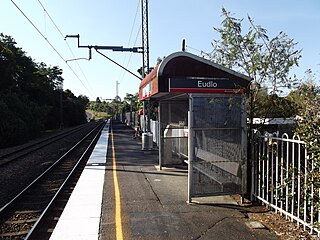
Eudlo railway station is located on the North Coast line in Queensland, Australia. It serves the town of Eudlo in the Sunshine Coast Region. It is one of few stations that can only fit 4 carriages onto the platform.

Theodore is a rural town and locality in the Shire of Banana, Queensland, Australia. It was established in the 1920s as part of Queensland Premier Ted Theodore's ambitious Dawson River Irrigation Scheme which failed to eventuate. It was originally known as Castle Creek, but that name is now used by another locality in the area.

The South Coast railway line was a railway from Brisbane, the capital city of Queensland, Australia. The route via the South Coast to Tweed Heads on the border of Queensland and New South Wales. The line operated from 1889 to 1964. Between 1903 and 1961 steam trains ran from Beenleigh to the NSW border. The Gold Coast railway line re-opened in 1996 along a modified alignment in the north and a new route south but does not extend as far south yet as the South Coast line.

Graceville is a suburb in the City of Brisbane, Queensland, Australia. In the 2021 census, Graceville had a population of 4,764 people.
Oxenford is a suburb in the City of Gold Coast, Queensland, Australia. In the 2021 census, Oxenford had a population of 12,273 people.

Coopers Plains is a southern suburb in the City of Brisbane, Queensland, Australia. In the 2021 census, Coopers Plains had a population of 5,675 people.
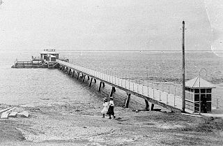
Southport Pier is a pier spanning the Gold Coast Broadwater in Southport, a suburb on the Gold Coast in South East Queensland, Australia. The current pier was constructed in 2009, replacing a previous structure demolished in 1969.

The Beaudesert Shire Tramway was a narrow gauge tramway which operated from Beaudesert to Lamington and Rathdowney in the Scenic Rim Region, Queensland, Australia, It was one of 15 light railways built and operated by Divisional Boards and Shire Councils in Queensland. The line carried passengers and cargo. It operated from 1903 to 1944. It was initially profitable and seen as a great success for the local shire council. The tramway is credited with opening up the agricultural lands of the upper Logan River.

Miva is a rural locality split between the Gympie Region and the Fraser Coast Region in Queensland, Australia. In the 2021 census, the locality of Miva had a population of 55 people.

Ideraway is a rural town and locality in the North Burnett Region, Queensland, Australia. In the 2021 census, the locality of Ideraway had a population of 31 people.

Christmas Creek is a rural locality in the Scenic Rim Region, Queensland, Australia. In the 2021 census, Christmas Creek had a population of 88 people.

Glenfern is a rural locality in the Somerset Region, Queensland, Australia. In the 2021 census, Glenfern had a population of 11 people.
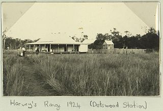
Dotswood is a rural locality in the Charters Towers Region, Queensland, Australia. In the 2021 census, Dotswood had a population of 83 people.
Owanyilla is a rural town and locality in the Fraser Coast Region, Queensland, Australia. In the 2021 census, the locality of Owanyilla had a population of 245 people.

Binjour is a rural locality in the North Burnett Region, Queensland, Australia. In the 2021 census, Binjour had a population of 86 people.
Turbot Street runs parallel to Ann Street and is on the northern side of the Brisbane CBD in Queensland, Australia. It is a major thoroughfare, linking as a three-to-five lane one-way street with the Riverside Expressway in the southwest to the suburb of Fortitude Valley in the northeast; address numbers run the same direction. It is a one-way pair with Ann Street.

Biarra is a rural locality in the Somerset Region, Queensland, Australia. In the 2021 census, Biarra had a population of 270 people.