French Polynesia is an overseas collectivity of France and its sole overseas country. It comprises 121 geographically dispersed islands and atolls stretching over more than 2,000 kilometres (1,200 mi) in the South Pacific Ocean. The total land area of French Polynesia is 3,521 square kilometres (1,359 sq mi), with a population of 278,786 of which at least 205,000 live in the Society Islands and the remaining population lives in the rest of the archipelago.
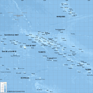
French Polynesia is located in Oceania. It is a group of six archipelagos in the South Pacific Ocean, about halfway between South America and Australia. Its area is about 4,167 km2, of which 3,827 km2 is land and 340 km2 is (inland) water. It has a coastline of 2,525 km but no land borders with other countries.
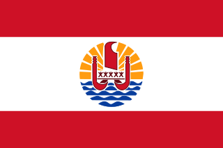
The flag of French Polynesia is the civil and state flag of the French overseas country French Polynesia. It was adopted in 1984. According to the articles of adoption, the flag of French Polynesia must be displayed with the French tricolor, and may be displayed with the flags of the component archipelagos. The French Polynesian flag must be displayed to the left of the French flag, and the flag of the archipelago must be displayed to its right.

Bora Bora is an island group in the Leeward Islands in the South Pacific. The Leeward Islands comprise the western part of the Society Islands of French Polynesia, which is an overseas collectivity of the French Republic in the Pacific Ocean. Bora Bora has a total land area of 30.55 km2 (12 sq mi). The main island, located about 230 kilometres northwest of Papeete, is surrounded by a lagoon and a barrier reef. In the center of the island are the remnants of an extinct volcano, rising to two peaks, Mount Pahia and Mount Otemanu; the highest point is at 727 m (2,385 ft). Bora Bora is part of the Commune of Bora-Bora, which also includes the atoll of Tūpai. The main languages spoken in Bora Bora are Tahitian and French. However, due to the high tourist population, many natives of Bora Bora have learned to speak English.

Ari'i-ʻOtare Teriʻi-maeva-rua III Pomare was the last Queen of the Tahitian island of Bora Bora from 1873 to 1895.
Air Tahiti is a French airline company which operates in French Polynesia. Its main hub is Faa'a International Airport. It is the largest private employer in French Polynesia.
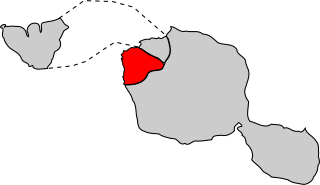
The Leeward Islands are the western part of the Society Islands in French Polynesia, an overseas collectivity of France, in the South Pacific Ocean. They lie south of the Line Islands, east of the Cooks and north of the Austral Islands. Their area is 404 km2 and their population is over 36,000.

The Society Islands are an archipelago in the South Pacific Ocean that includes the major islands of Tahiti, Moʻorea, Raiatea, Bora Bora and Huahine. Politically, they are part of French Polynesia, an overseas country of the French Republic. Geographically, they form part of Polynesia.

Gaston Tong Sang is a French Polynesian politician and is the former President of French Polynesia. He served terms as President of French Polynesia from November 2009 until April 2011, from April 2008 until February 2009 and from December 2006 until September 2007; he is currently the Mayor of Bora-Bora. He is of Chinese descent, and is a founding member of French Polynesia's pro-French Tahoera'a Huiraatira political party.

Bora Bora Airport, also known as Motu Mute Airport, is an airport serving the island of Bora Bora in French Polynesia. It is located on the islet of Motu Mute.

Huahine – Fare Airport is an airport serving the island of Huahine in French Polynesia. The airport is located in the northern part of the commune of Fare, on the Island of Huahine Fare, French Polynesia.

This page list topics related to French Polynesia.

Severe Tropical Cyclone Wasa–Arthur was the first major tropical cyclone to affect French Polynesia and Tahiti since the 1982–83 season. The system was first noted on 3 December 1991, as a shallow tropical depression that was embedded within the monsoon trough, to the north of the Cook Island: Rarotonga. Over the next couple of days the system gradually developed further, before it was classified as a tropical cyclone and named Wasa on 5 December. The following day, as it performed a small clockwise loop, the system strengthened further and acquired hurricane-force winds. After completing the loop, Wasa moved southwards before it peaked in intensity during 8 December, with sustained wind speeds of 165 km/h (105 mph). Over the next few days the system started to weaken as it passed through the French Polynesian Society Islands, and became the first major tropical cyclone to affect French Polynesia since 1983.

Vaitape is the largest city of Bora Bora Island in French Polynesia. It has a population of 4,927, about half of the island's population which is about 10,605. It is located about 210 km (130 mi) northwest of Papeete, the capital of French Polynesia. The main language of Vaitape is French, although 20 percent of the population speaks Tahitian.

Severe Tropical Cyclone Osea was the second of seven cyclones to affect French Polynesia during the 1997–98 South Pacific cyclone season. The fourth tropical cyclone and second severe tropical cyclone of the very active season, Osea began as a low that formed on November 22, and the storm initially remained weak. Moving south and later east, it was named Osea on November 24 after achieving windspeeds equal to a Category 1 cyclone on the Australian tropical cyclone intensity scale. Continuing to intensify, Osea soon reached its peak intensity of 90 mph (145 km/h). Afterwards, Osea began to weaken because of increased wind shear, and the cyclone started moving southeast. By November 28, Osea was no longer a tropical cyclone.

Motu Tane, is a 9.6-acre (0.039 km2) private island in the lagoon of Bora Bora in French Polynesia. It is the located between Paahi, and Pitoraverahi.
Motu Vananui is a 0.013 km2 (0.0050 sq mi) island in the Bora Bora Islands Group, within the Society Islands of French Polynesia. It is the located between Paahi, and Mouti.
French Polynesia's third constituency is a French legislative constituency in French Polynesia. It is represented by Moetai Brotherson of Tavini Huiraatira.

