Related Research Articles

Mato Grosso is one of the states of Brazil, the third largest by area, located in the Central-West region. The state has 1.66% of the Brazilian population and is responsible for 1.9% of the Brazilian GDP.

Mato Grosso do Sul is one of the Midwestern states of Brazil. Neighboring Brazilian states are Mato Grosso, Goiás, Minas Gerais, São Paulo and Paraná. It also borders the countries of Paraguay, to the southwest, and Bolivia, to the west. The economy of the state is largely based on agriculture and cattle-raising. Crossed in the south by the Tropic of Capricorn, Mato Grosso do Sul generally has a warm, sometimes hot, and humid climate, and is crossed by numerous tributaries of the Paraná River. The state has 1.3% of the Brazilian population and is responsible for 1.5% of the Brazilian GDP.

Classification of Indigenous peoples of the Americas is based upon cultural regions, geography, and linguistics. Anthropologists have named various cultural regions, with fluid boundaries, that are generally agreed upon with some variation. These cultural regions are broadly based upon the locations of Indigenous peoples of the Americas from early European and African contact beginning in the late 15th century. When Indigenous peoples have been forcibly removed by nation-states, they retain their original geographic classification. Some groups span multiple cultural regions.

Cáceres is a municipality in the Brazilian state of Mato Grosso. It covers an area of 24,000km2 and as of 2020 had an estimated population of 94,861.
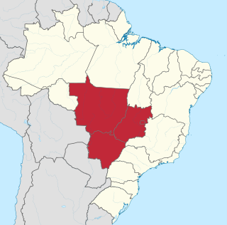
The Central-West or Center-West Region of Brazil is composed of the states of Goiás, Mato Grosso and Mato Grosso do Sul; along with Distrito Federal, where Brazil's national capital, Brasília, is situated. The region comprises 18.86% of the national territory.

Sinop is a city in the Brazilian state of Mato Grosso. The fourth-largest city in the state, its population in 2020 is estimated at more than 199,680 inhabitants, placing Sinop in 229th place in Brazil. It has an area of 3194.339 km ². A Sivam radar has been installed for monitoring the Amazon Basin. Also Embrapa has a branch in Sinop, the only one in the state of Mato Grosso. It is known as the Capital of Nortão, a major city of northern Mato Grosso.

Nova Andradina is a municipality located in the Brazilian state of Mato Grosso do Sul. Its population was 45,585 (2020) and its area is 4,776 km². It is known as the "Capital of the Ivinhema Valley."
The Atelchu River is a river of Mato Grosso state in western Brazil.
The Auaiá-Miçu River is a river located in the Mato Grosso state of western Brazil.
The Ferro River is a river of Mato Grosso state in western Brazil. It flows northeast, receives the Steinen River from the south, enters the Xingu Indigenous Park, receives the combined Ronuro and Jatoba rivers from the south and joins the Xingu River which flows north into the Amazon.
The Huaiá-Miçu River is a river of Mato Grosso state in western Brazil.
The Manissauá-Miçu River is a river of Mato Grosso state in western Brazil.
The Anhanduìzinho River is a river of Mato Grosso do Sul state in southwestern Brazil.

The Rio Negro is a river of Mato Grosso do Sul state in southwestern Brazil.

Gaúcha do Norte is a municipality in the state of Mato Grosso in the Central-West Region of Brazil.

Campos de Júlio is a municipality in the state of Mato Grosso in the Central-West Region of Brazil.

Alto Garças is a municipality) in the south-east of the Brazilian State of Mato Grosso with a population of about 12,000 on an area of 3672 km. The distance to the state capital Cuiabá is approximately 350 km². In 1933 Alto Garças became a district of the municipality of Santa Rita do Araguaia and on 10 December 1953 it was separated as an independent entity. Alto Garças is part of the micro-region Alto Araguaia.
The Legislative Assembly of Mato Grosso is the unicameral legislature of Mato Grosso state in Brazil. It has 24 state deputies elected by proportional representation.
References
Coordinates: 13°03′15″S53°25′11″W / 13.0542°S 53.4196°W