Paddington was a civil parish and metropolitan borough in London, England. It was an ancient parish in the county of Middlesex, governed by an administrative vestry. The parish was included in the area of responsibility of the Metropolitan Board of Works in 1855 and became part of the County of London in 1889. The parish of Paddington became a metropolitan borough in 1900, following the London Government Act 1899, with the parish vestry replaced by a borough council. In 1965 the borough was abolished and its former area became part of the City of Westminster in Greater London.

Cumberland County is a county in the State of New South Wales, Australia. Most of the Sydney metropolitan area is located within the County of Cumberland.

Darbalara is a rural community on the east bank of the junction of the Murrumbidgee River and Tumut River in the Riverina. It is situated by road, about 25 kilometres north east of Gundagai and 25 kilometres south of Coolac.

Gloucester County was one of the original Nineteen Counties in New South Wales, and is now one of the 141 cadastral divisions of New South Wales. It includes the area around Port Stephens. It is bounded on the north and west by the Manning River, and on the south-west by the Williams River.

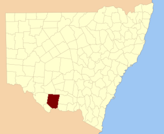
St Vincent County was one of the original Nineteen Counties in New South Wales and is now one of the 141 Cadastral divisions of New South Wales. It included the south coast area encompassing Batemans Bay, Ulladulla, Jervis Bay and inland to Braidwood. The Shoalhaven River is the boundary to the north and west, and the Deua River the boundary to the south.

Yancowinna County is one of the 141 Cadastral divisions of New South Wales.
Townsend County is one of the 141 Cadastral divisions of New South Wales. It is in the south of New South Wales with the Murray River to the south. Deniliquin is located there.

Cowper County, New South Wales is one of the 141 Cadastral divisions of New South Wales.

Evelyn County is one of the 141 Cadastral divisions of New South Wales, Australia.
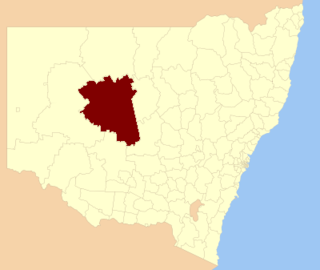
Gordon County is one of the 141 Cadastral divisions of New South Wales. The Macquarie River is the north-eastern boundary.

Gowen County is one of the 141 Cadastral divisions of New South Wales. It is located to the east of the Castlereagh River in the area to the east of Gilgandra, to Coonabarabran in the north-east. This includes land on both sides of the Newell Highway.

Kennedy County is one of the 141 Cadastral divisions of New South Wales. It is located to the west of the Bogan River in the area around Tottenham and Tullamore.

Mootwingee County, New South Wales is one of the 141 Cadastral divisions of New South Wales.

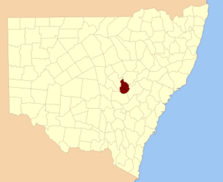
Oxley County, New South Wales is one of the 141 Cadastral divisions of New South Wales. It is located between the Bogan River on the west, and the Macquarie River on the east. This is the area approximately between Warren and Nyngan.
Waverley was an electoral district of the Legislative Assembly in the Australian state of New South Wales, originally created in 1894, with the abolition of multi-member constituencies, out of part of Paddington, and named after and including the Sydney suburb of Waverley. In 1920, with the introduction of proportional representation, it was absorbed into Eastern Suburbs. Waverley was recreated in 1927. In 1959 parts of Waverly and Paddington were combined to form Paddington-Waverley, which was abolished in 1962 and replaced by Bligh. In 1971, Bondi and Randwick were abolished and partly replaced by a recreated Waverley. At the 1990 redistribution, Waverley was abolished again and absorbed into Coogee and Vaucluse.

Alexandria Parish is one of the 57 parishes of Cumberland County, New South Wales, a cadastral unit for use on land titles. It contains the area to the south and east of Sydney city including Bondi, Paddington and Clovelly. It was probably named after the Battle of Alexandria fought in 1801.

Indi, New South Wales, located at 29°48'45.0"S 143°24'00.0"E is a Parish of Ularara County in north west New South Wales. It is between Milparinka, New South Wales and Wilcannia.

Blowering, New South wales is a rural locality in the Snowy Mountains of New South wales and a civil Parish of Buccleuch County.
Yarrangobilly, New South Wales is a rural locality in the Snowy Mountains, west of Canberra, Australia, and is also a civil Parish of Buccleuch County.
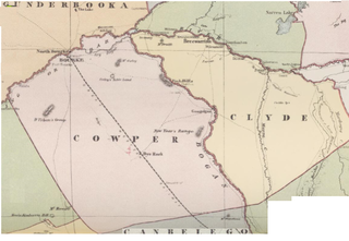
Maffra Parish, New South Wales is a Bounded locality of Bourke Shire and a civil Parish of Cowper County, New South Wales, a cadasteral division of central New South Wales.