External links
![]() Media related to Page Bank The Barrow at Wikimedia Commons
Media related to Page Bank The Barrow at Wikimedia Commons
| | This County Durham location article is a stub. You can help Wikipedia by expanding it. |
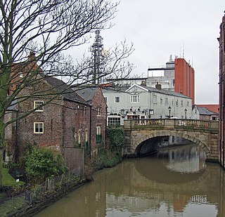
Page Bank is a village in County Durham, in England. It is situated on the north bank of the River Wear to the east of Willington and to the north-west of Spennymoor.
![]() Media related to Page Bank The Barrow at Wikimedia Commons
Media related to Page Bank The Barrow at Wikimedia Commons
| | This County Durham location article is a stub. You can help Wikipedia by expanding it. |

The River Wharfe is a river in Yorkshire, England. For much of its length it is the county boundary between West Yorkshire and North Yorkshire.
The River Foss is in North Yorkshire, England. It is a tributary of the River Ouse. It rises in the Foss Crooks Woods near Oulston Reservoir close to the village of Yearsley and runs south through the Vale of York to the Ouse in the centre of York. The name most likely comes from the Latin word Fossa, meaning ditch. It is mentioned in the Domesday Book. The York district was settled by Norwegian and Danish people, so parts of the place names could be old Norse. Referring to the etymological dictionary "Etymologisk ordbog", ISBN 82-905-2016-6 dealing with the common Danish and Norwegian languages – roots of words and the original meaning. The old Norse word Fos (waterfall) meaning impetuous. The River Foss was dammed, and even though the elevation to the River Ouse is small, a waterfall was formed. This may have led to the name Fos which became Foss.

The River Swale in Yorkshire, England, is a major tributary of the River Ure, which becomes the River Ouse, that empties into the North Sea via the Humber Estuary. The river gives its name to Swaledale, the valley through which it flows.

Cringle Moor, at 432 m (1,417 ft), is the third highest hill in the North York Moors, England, and the highest point west of Clay Bank.

Donegall Square is a square in the centre of Belfast, County Antrim, Northern Ireland. In the centre is Belfast City Hall, the headquarters of Belfast City Council. Each side of the square is named according to its geographical location, i.e. Donegall Square North, South, East and West. It is named after the Donegall family. Other streets to bear their name in Belfast are Donegall Road, Donegall Pass and Donegall Street. Donegall Place, the city's main shopping street, runs from the north side of the square.

Cod Beck is a river in North Yorkshire, England. It has a catchment area of 209 km2 (81 sq mi).

The A592 road is a major route running north–south through the English Lake District.

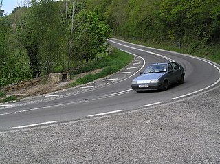
The A591 is a major road in Cumbria, in the north-west of England, which lies almost entirely within the Lake District national park. A 2009 poll by satellite navigation firm Garmin named the stretch of the road between Windermere and Keswick as the most popular road in Britain. The 29.8 mile stretch between Kendal and Keswick was also named the UK's best driving road, according to a specially devised driving ratio formulated by car rental firm Avis.
The A170 is an A road in North Yorkshire, England that links Thirsk with Scarborough through Hambleton, Helmsley, Kirkbysmoorside, Pickering. The road is 47 miles (76 km); a single carriageway for almost its totality.

Redcar Racecourse is a thoroughbred horse racing venue located in Redcar, North Yorkshire, England. The present course was opened in 1870 or 1875, previously Redcar races were held on the sands at Coatham. Its address is Redcar Racecourse Ltd, Thrush Road, Redcar TS10 2BY.

Quita Sueño Bank is a reef formation of Colombia which was once claimed by the United States, located 110 km north-northeast of Providencia Island.
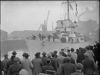
HMS Affleck was a Captain-class frigate which served during World War II. The ship was named after Sir Edmund Affleck, commander of HMS Bedford at the Moonlight Battle in 1780 during the American Revolutionary War.

Camboglanna was a Roman fort. It was the twelfth fort on Hadrian's Wall counting from the east, between Banna (Birdoswald) to the east and Uxelodunum (Stanwix) to the west. It was almost 7 miles (11 km) west of Birdoswald, on a high bluff commanding the Cambeck Valley. It guarded an important approach to the Wall and also watched the east bank of the Cambeck against raiders from the Bewcastle area. The site was drastically levelled in 1791 when the gardens of Castlesteads House were laid over it. The name "Camboglanna" is believed to mean "Crook Bank", or "Bent Valley" because it overlooks a bend in the river Irthing; the name is Brythonic, made of cambo- "curved, bent, crooked" and glanna "steep bank, stream/river side, valley with a stream".
The Tahltan First Nation, also known as the Tahltan Indian Band, is a band government of the Tahltan people. Their main community and reserves are located at Telegraph Creek, British Columbia. Their language is the Tahltan language, which is an Athabaskan language also known as Nahanni, is closely related to Kaska and Dunneza. Their Indian and Northern Affairs Canada band number is 682. The Tahltan First Nation is joined with the Iskut First Nation in a combined tribal council-type organization known as the Tahltan Nation.

The Irish Sea separates the islands of Ireland and Great Britain; linked to the Celtic Sea in the south by St George's Channel, and to the Inner Seas off the West Coast of Scotland in the north by the North Channel, also known as the Straits of Moyle.

Milecastle 11 was a milecastle of the Roman Hadrian's Wall. No remains exist, but the measured position is the middle of the old village of Throckley Bank Top, under the Working Men's Club.

The Stedman–Thomas Historic District encompasses what was historically the southern portion of Ketchikan, Alaska. It extends along Stedman and Thomas Streets, from Ketchikan Creek in the north to East Street in the south, and includes a few properties on adjacent spur side streets. In the early days of the city, the area was a seasonal Native fishing camp just south of the creek, but the Alaskan gold rushes around the turn of the 20th century brought an influx of settlers to the area.

National Cycle Network (NCN) Route 65 is a Sustrans National Route that runs from Hornsea on the North Sea Coast of The East Riding of Yorkshire via Hull and York to Middlesbrough. It is fully open and signed.
National Cycle Network (NCN) Route 656 is a Sustrans regional route in North Yorkshire. A 18.5 miles (29.8 km) cycle way between Coxwold and a junction with NCN Route 65 near Osmotherley via Sutton Bank National Park Centre and Hawnby. The route is fully opened and signed, it is on-road using quiet country lanes. Sustrans describe it as “a very strenuous route.”