
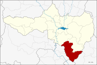
Nakhon Ratchasima is one of Thailand's seventy-six provinces (changwat) lies in lower northeastern Thailand also called Isan. At 20,494 sq km it is the country's largest province by area, has a population of approximately 2.7 million, and generates about 250 billion baht in GDP, the highest in Isan. Neighbouring provinces are Chaiyaphum, Khon Kaen, Buriram, Sa Kaeo, Prachinburi, Nakhon Nayok, Saraburi, and Lopburi.

Suphan Buri located in the central region of Thailand, is one of the country's 76 provinces, the first-level administrative divisions. Neighbouring provinces are Uthai Thani, Chai Nat, Sing Buri, Ang Thong, Phra Nakhon Si Ayutthaya, Nakhon Pathom and Kanchanaburi. As of 2018 the province counted a population of around 848,700, representing about 1.28% of the country's population.

Bang Bua Thong is a district (amphoe) of Nonthaburi province, central Thailand.

Pak Kret is a district (amphoe) in the northeastern part of Nonthaburi province, central Thailand.

Ang Thong is a town in Thailand, capital of Ang Thong Province. The town covers the entirety of tambon Talat Luang and Bang Kaeo as well as parts of tambon Sala Daeng, Ban Hae, Ban It, Pho Sa, and Yansue, all of Mueang Ang Thong District. As of 2006 it had a population of 13,738. The town is on the Chao Phraya River.
Thakhli is the southernmost district (amphoe) of Nakhon Sawan province, Thailand.
Mueang Nakhon Ratchasima is one of 32 districts of Nakhon Ratchasima province, northeastern Thailand.
Khon Buri is a district (amphoe) in the southern part of Nakhon Ratchasima province, northeastern Thailand.
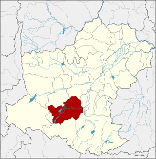
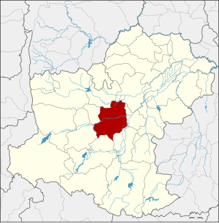
Pak Thong Chai is a district (amphoe) in the southern part of Nakhon Ratchasima province, northeastern Thailand.

Pa Mok is the southernmost district (amphoe) of Ang Thong province, central Thailand.

Wiset Chai Chan is a district (amphoe) in the southwestern part of Ang Thong province, central Thailand.

Bang Saphan is a district (amphoe) in the southern part of Prachuap Khiri Khan province, central Thailand.

Mueang Ang Thong is the capital district of Ang Thong province, central Thailand.

Klaeng is a district (amphoe) on the coast of Rayong province, eastern Thailand.

Mueang Uttaradit is the capital district of Uttaradit province, northern Thailand.

Selaphum is a district (amphoe) in the eastern part of Roi Et province, northeastern Thailand.

Nong Phok is a district (amphoe) in the northeastern part of Roi Et province, northeastern Thailand.
Chai Nam is a subdistrict in Wang Thong district, Phitsanulok province. It is connected to Highways 11 and 12. In 2022 it had a population of 6,205. The economy is mainly based on agriculture.
Nok Ok is a subdistrict (tambon) and a subdistrict municipality in Pak Thong Chai District, Nakhon Ratchasima Province, Thailand.

Khlong Wang Chao National Park is a national park in Thailand.
This page is based on this
Wikipedia article Text is available under the
CC BY-SA 4.0 license; additional terms may apply.
Images, videos and audio are available under their respective licenses.