
Kathmandu, officially the Kathmandu Metropolitan City, is the seat of federal government and the most populous city in Nepal. As of the 2021 Nepal census, there were 845,767 inhabitants living in 105,649 households and approximately 4 million people in its surrounding agglomeration. It is located in the Kathmandu Valley, a large valley surrounded by hills in the high plateaus in central Nepal, at an altitude of 1,400 metres.

Nepal measures about 880 kilometers (547 mi) along its Himalayan axis by 150 to 250 kilometers across. It has an area of 147,516 km2 (56,956 sq mi).

The Himalayas, or Himalaya is a mountain range in Asia, separating the plains of the Indian subcontinent from the Tibetan Plateau. The range has some of the Earth's highest peaks, including the highest, Mount Everest. More than 100 peaks exceeding elevations of 7,200 m (23,600 ft) above sea level lie in the Himalayas.

The Bagmati River flows through the Kathmandu valley of Nepal, separating the cities of Kathmandu and Patan, before flowing through Madesh Province of southern Nepal and joining the Kamla River in the Indian state of Bihar. It is considered holy by both Hindus and Buddhists. A number of Hindu temples are located on its banks.
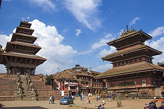
Bhaktapur, known locally as Khwopa and historically called Bhadgaon, is a city in the east corner of the Kathmandu Valley in Nepal located about 13 kilometres (8.1 mi) from the capital city, Kathmandu. Bhaktapur is the smallest city of Nepal as well as the most densely populated. Along with Kathmandu and Lalitpur, Bhaktapur is one of the three main cities of the Kathmandu Valley and is a major Newar settlement of the country. The city is also known for its Newar tradition, cuisine and artisans. Bhaktapur suffered heavy damage in the April 2015 earthquake.

The Kathmandu Valley, also known as the Nepal Valley or Nepa Valley, National Capital Area, is a bowl-shaped valley located in the Himalayan mountains of Nepal. It lies at the crossroads of ancient civilizations of the Indian subcontinent and the broader Asian continent, and has at least 130 important monuments, including several pilgrimage sites for Hindus and Buddhists. There are seven World Heritage Sites within the valley.

Swayambhu Mahachaitya is an ancient religious complex atop a hill in the Kathmandu Valley, west of Kathmandu city. The Tibetan name for the site means 'Sublime Trees', for the many varieties of trees found on the hill. However, Shingun may be of in Nepal Bhasa name for the complex, Swayambhu, meaning 'self-sprung'. For the Buddhist Newars, in whose mythological history and origin myth as well as day-to-day religious practice Swayambhu occupies a central position, it is the most sacred among Buddhist pilgrimage sites. For Tibetans and followers of Tibetan Buddhism, it is second only to Boudha. Swayambhu is the Hindu name.

A glacial lake outburst flood (GLOF) is a type of outburst flood caused by the failure of a dam containing a glacial lake. An event similar to a GLOF, where a body of water contained by a glacier melts or overflows the glacier, is called a jökulhlaup. The dam can consist of glacier ice or a terminal moraine. Failure can happen due to erosion, a buildup of water pressure, an avalanche of rock or heavy snow, an earthquake or cryoseism, volcanic eruptions under the ice, or massive displacement of water in a glacial lake when a large portion of an adjacent glacier collapses into it.
Swayambhu Purana or Svayambhū Purāṇa is a Buddhist scripture about the origin and development of Kathmandu valley. Swayambhu Purana gives details of all the Buddhas who came to Kathmandu. It also provides information about the first and the second Buddhas in Buddhism.

Bajrayogini Temple(Nepali: बज्रयोगिनी मन्दिर) is a Tantric Buddhist temple located at Sakwa in Nepal's Kathmandu Valley. It is also well known as Bodhisattva's Temple. The temple is actually a sort of temple complex, with the main temple having been built by King Pratap Malla in the sixteenth century. Vajrayogini is a Buddhist tantric deity, she is also conflated with Ugra Tara, a form of the Buddhist dharmapala Ekajati. However, the temple is sacred to both Buddhists and Hindus.

Chobhar caves are an extensive network of natural phreatic caves near the village of Chobhar, which is located 9 km southwest of Kathmandu, Nepal. Chobhar is also known for the Chobhar gorge through which all the water of the valley drains. A small temple of Adinath Sampradaya sits on top of a nearby hill. The temple offers a view of snow-capped mountains. According to Swayambhu Purana and legend, Kathmandu Valley was once a lake. It is believed that the bodhisattva Manjushree cut a gorge at a place called Chobhar Gorge, near Chobhar Ancient Hill Village and drained away the waters to establish a habitable land.
The Inner Terai Valleys of Nepal comprise several elongated river valleys in the southern lowland Terai part of the country. These tropical valleys are enclosed by the Himalayan foothills, viz the Mahabharat Range and the Sivalik Hills farther south.

Chobhar is a village in Kathmandu District in the Bagmati Zone of central Nepal and part of Kirtipur Municipality. At the time of the 1991 Nepal census it had a population of 5,627 living in 1,109 households.
Sankhu is the ancient Newar town located in the north-eastern corner of Kathmandu Valley which is about 17 km from the city center of Kathmandu. Sankhu was formerly divided into three Village Development Committee, namely, Pukhulachhi, Suntol and Bajrayogini. Recently the town of Sankhu has been declared as Shankharapur Municipality merging three above-mentioned VDCs and other neighbouring VDCs. At the time of the 2011 Nepal census it had a population of 4333 living in 928 individual households. Sankhu lies between river Salinakhu in east and Asakhu in the west.

The history of the city of Kathmandu, which is inseparable from that of the Kathmandu valley, dates back to ancient times.

Dharma Man Tuladhar was a Nepalese trader and philanthropist best known for the renovation of the Swayambhu stupa in Kathmandu, one of the holiest Buddhist shrines in Nepal.

The architectural heritage of Kathmandu city is integral to that of the Kathmandu valley since all monuments have evolved over centuries of craftsmanship influenced by Hindu and Buddhist religious practices. The architectural treasure of the Kathmandu valley has been categorized under the well known seven groups of heritage monuments and buildings. In 2006, UNESCO declared these seven groups of monuments as a World Heritage Site (WHS). The seven monuments zones cover an area of 188.95 hectares, with the buffer zone extending to 239.34 hectares. The Seven Monument Zones (Mzs) inscribed originally in 1979 with a minor modification in inscribed year as 2006, are: Five monuments in Kathmandu – Durbar square of Hanuman Dhoka, Hindu temples of Pashupatinath and Changunarayan, the Buddha stupas of Swayambu and Boudhanath; and two monuments outside Kathmandu city limits, in the satellite towns of Patan and Bhktapur – Durbar square at Patan, Durbar square at Bhaktapur. Brief details of the five Kathmandu city monuments are elaborated here.
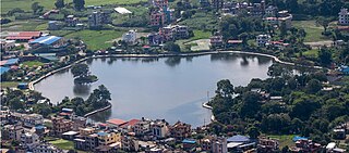
Taudaha Lake is a small lake in the outskirts of Kathmandu, in Nepal.
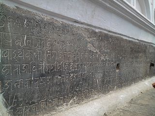
Stone inscriptions in the Kathmandu Valley refer to ancient stone slabs, pillars and pedestals with text carved on them. They are the most important sources for the history of Nepal. A vast majority of the inscriptions found in Nepal are from the Kathmandu Valley where they are an ubiquitous element at heritage sites. They consist of royal edicts and dedicatory notes on Hindu and Buddhist temples, stupas, statues, water spouts and other architectural structures. Stone inscriptions are locally referred as Lōhan Pau.
The Tsergo Ri landslide was a prehistoric landslide in the Nepalese Himalaya, which took place around 51,000±13,000 years ago, during the Last Glacial Period. During the collapse, a mass of rock of about 10–15 cubic kilometres (2.4–3.6 cu mi) detached from a previous mountain or ridge and descended with a speed of about 450 kilometres per hour (120 m/s); later, glaciers eroded almost the entire landslide mass. Previously weakened rocks may have contributed to the collapse, which was probably started by an earthquake.


