
Teton County is a county in the U.S. state of Wyoming. As of the 2010 United States Census, the population was 21,294. Its county seat is Jackson. Its west boundary line abuts the east line of the state of Idaho.

Teton County is a county located in the U.S. state of Idaho. As of the 2010 census, the population was 10,170. The county seat is Driggs, and the largest city is Victor. The county was established in 1915 and was named after the Teton Mountains to the east.

Fremont County is a county located in the U.S. state of Idaho. As of the 2010 census the county had a population of 13,242. The county seat and largest city is St. Anthony. The county was established in 1893, and was named for the explorer John C. Frémont.

Bonneville County is a county located in the U.S. state of Idaho. As of the 2010 census, the county had a population of 104,234, making it the fourth-most populous county in Idaho and the most populous in eastern Idaho. Its county seat and largest city is Idaho Falls. Bonneville County was established in 1911 and named after Benjamin Bonneville (1796–1878), a French-born officer in the U.S. Army, fur trapper, and explorer in the American West. Benjamin was the son of Nicholas Bonneville of France. His father was an Illuminati member and wrote the "Illuminati Manifesto for World Revolution" in 1792, which played a significant role in the French revolution.

Island Park is a city in Fremont County, Idaho, United States. The city's population was 286 at the 2010 census, up from 215 in 2000. The city was incorporated by owners of the many lodges and resorts along U.S. Route 20 in 1947, primarily to circumvent Idaho's liquor laws that prohibited the sale of liquor outside of city limits. It is only 500 feet (150 m) wide in most locations and, at 33 miles (53 km), claims to have the longest "Main Street" in the world.

The Territory of Idaho was an organized incorporated territory of the United States that existed from March 3, 1863, until July 3, 1890, when the final extent of the territory was admitted to the Union as Idaho.

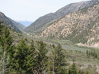
Teton Pass is a high mountain pass in the western United States, located at the southern end of the Teton Range of western Wyoming, between the towns of Wilson, Wyoming and Victor, Idaho. The pass provides access from the Jackson Hole valley to the Teton Valley of eastern Idaho, which includes the access route to Grand Targhee Resort through Driggs, Idaho. To the south of the pass, lies the Snake River Range.

Caribou-Targhee National Forest is located in the states of Idaho and Wyoming, with a small section in Utah in the United States. The forest is broken into several separate sections and extends over 2.63 million acres (10,600 km2). To the east the forest borders Yellowstone National Park, Grand Teton National Park and Bridger-Teton National Forest. Most of the forest is a part of the 20-million-acre (81,000 km2) Greater Yellowstone Ecosystem.

Grand Targhee Resort is a ski resort in the western United States, located in western Wyoming in the Caribou-Targhee National Forest, near Alta, the closest town to the resort. It is 42 miles (68 km) northwest of Jackson and is accessible only from the west, through Driggs, Idaho. The border with Idaho is less than five miles due west.
Caribou Mountains are a mountain range in the Rocky Mountains in Idaho, United States. The mountains are in the Caribou National Forest in Bonneville and Caribou counties, near the Wyoming border.
Cache National Forest is a 533,840-acre area of National Forest System land in Idaho and Utah which was established on July 1, 1908 by the U.S. Forest Service. The majority of its area is in Utah, and was initially created when the Bear River National Forest was disbanded. On July 1, 1915, all of Pocatello National Forest was added. In 1973 the Idaho portion was transferred to the administration of Caribou National Forest, while the Utah portion was combined administratively with Wasatch National Forest, creating the Wasatch-Cache National Forest. In descending order of forestland area, the Cache National Forest portion is located in Cache, Bear Lake, Franklin, Weber, Rich, Box Elder, Caribou, and Morgan counties. The forest has a current area of 701,453 acres (2,838.68 km2), which comprises 43.56% of the combined Wasatch-Cache's total acreage. The forest is administered from Salt Lake City, Utah as part of the Wasatch-Cache National Forest, but there are local ranger district offices in Logan and Ogden. From circa 1911 until August 1923, the area was roamed by Old Ephraim.

The Targhee is a breed of domestic sheep developed in early 20th century by the USDA's Agricultural Research Service. Targhee sheep are a dual-purpose breed, with heavy, medium quality wool and good meat production characteristics. They are hardy, and are especially suited to the ranges of the West where they were developed. Targhee are especially popular in Montana, Wyoming and South Dakota, where their ¾ fine wool and ¼ long wool breeding is favored by western ranchers. This breed is raised primarily for wool.

Wasatch National Forest was established as the Wasatch Forest Reserve by the U.S. Forest Service in Utah on August 16, 1906 with 86,440 acres (349.8 km2) to the east of Salt Lake City and Provo. It became a National Forest on March 4, 1907. On July 1, 1908 Grantsville National Forest and Salt Lake National Forest were added. In 1973 Wasatch was combined administratively with Cache National Forest, creating Wasatch-Cache National Forest. In descending order of acreage, the Wasatch National Forest portion is located in Summit, Tooele, Salt Lake, Davis, Uinta (Wyoming), Duchesne, Wasatch, Morgan, Utah, Weber, and Juab counties in Utah except Uinta, which is in southwestern Wyoming. Its total area was 908,731 acres (3,677.50 km2), comprising 56.44% of the combined Wasatch-Cache's 1,610,184 acres (6,516.18 km2) as of 2008. There are local ranger district offices in Kamas and Salt Lake City in Utah, and in Evanston and Mountain View in Wyoming. Administrative headquarters reside with the combined Uinta-Wasatch-Cache National Forest in South Jordan, Utah.
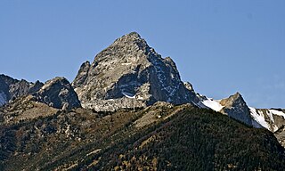
Buck Mountain 11,943 feet (3,640 m) is located in the Teton Range, Grand Teton National Park, Wyoming, immediately southeast of Grand Teton. The mountain is the highest summit south of Garnet Canyon and is easily seen from most vantage points in Jackson Hole. Views from the summit offer excellent views of the Cathedral Group to the north. The west slope of the summit tower are along the Alaska Basin Trail and extend into Caribou-Targhee National Forest and the Jedediah Smith Wilderness, which is the location of Alaska Basin, a popular wilderness camping area for backpackers. Timberline Lake is located on the eastern flanks of the peak.

The U.S. Sheep Experiment Station (USSES) is an agricultural experiment station focusing on domestic sheep which is run by the United States Department of Agriculture's Agricultural Research Service. Its stated mission is "...to develop integrated methods for increasing production efficiency of sheep and to simultaneously improve the sustainability of rangeland ecosystems".

Yellowstone National Forest was first established by the General Land Office on March 30, 1891 as the Yellowstone Park Timber Land Reserve of 1,239,040 acres (5,014.2 km2). On May 22, 1902 it became the Yellowstone Forest Reserve with lands of 6,580,920 acres (26,632.0 km2).
Henry's Lake National Forest was established as the Henry's Lake Forest Reserve by the U.S. Forest Service in Idaho on May 23, 1905 with 798,720 acres (3,232.3 km2). It became a National Forest on March 4, 1907. On July 1, 1908 the entire forest was combined with a portion of Yellowstone National Forest to establish Targhee National Forest and the name was discontinued.
Table Mountain is located in the Teton Range in the U.S. state of Wyoming. The peak is on the border of Grand Teton National Park and the Jedediah Smith Wilderness of Caribou-Targhee National Forest. Table Mountain is west of the south fork of Cascade Canyon and a little more than 1 mile (1.6 km) north of Hurricane Pass.

Teton Valley is an area located on the west slope of the Teton Mountain Range and is known as "The quiet side of the Tetons." It is composed of the cities of Victor, Idaho, Driggs, Idaho, Tetonia, Idaho, and Alta, Wyoming. Teton Valley is a rural, agriculture and ranching based economy with a shifting emphasis towards recreational tourism.


