
Alappuzha district, is one of the 14 districts in the Indian state of Kerala. It was formed as Alleppey district on 17 August 1957, the name of the district being changed to Alappuzha in 1990, and is the smallest district of Kerala. Alleppey town, the district headquarters, was renamed Alappuzha in 2012, even though the anglicised name is still commonly used to describe the town as well as the district.

Kottayam, is one of 14 districts in the Indian state of Kerala. Kottayam district comprises six municipal towns: Kottayam, Changanassery, Pala, Erattupetta, Ettumanoor, and Vaikom. It is the only district in Kerala that neither borders the Arabian Sea nor any other states.

Idukki (ഇടുക്കി), IPA: [iɖukːi], is one of the 14 districts in the Indian state of Kerala. Idukki district lies amid the Cardamom Hills of Western Ghats in Kerala. Idukki district contains two municipal towns - Kattappana and Thodupuzha. The district currently includes five taluks in it.
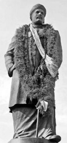
Ayyankali was an Indian politician, prominent social reformer, educator, economist, lawmaker, and a revolutionary leader. He worked for the advancement of the oppressed people in the princely state of Travancore. His struggle resulted in many changes that improved the socio-political structure of Kerala. His determined and relentless efforts changed the lives of Dalits.

Thiruvalla, alternately spelled Tiruvalla, is a town in Kerala and the Headquarters of the Taluk of the same name located in Pathanamthitta district in the State of Kerala, India. The town is spread over an area of 27.94 km2 (10.79 sq mi). It lies on the banks of the Pambas and Manimala rivers, and is a land-locked region surrounded by irrigating streams and rivers.It is the largest town in the district and central Travancore.

The Kerala backwaters are a network of brackish lagoons and canals lying parallel to the Arabian Sea of the Malabar coast of Kerala state in south-western India. It also includes interconnected lakes, rivers, and inlets, a labyrinthine system formed by more than 900 km (560 mi) of waterways, and sometimes compared to bayous. The network includes five large lakes linked by canals, both man made and natural, fed by 38 rivers, and extending virtually half the length of Kerala state. The backwaters were formed by the action of waves and shore currents creating low barrier islands across the mouths of the many rivers flowing down from the Western Ghats range. In the midst of this landscape there are a number of towns and cities, which serve as the starting and end points of backwater cruises. There are 34 backwaters in Kerala. Out of it, 27 are located either closer to Arabian Sea or parallel to the sea. The remaining 7 are inland navigation routes.

Vembanad is the longest lake in India, as well as the largest lake in the state of Kerala. The lake has an area of 230 square kilometers and a maximum length of 96.5 km. Spanning several districts in the state of Kerala, it is known as Vembanadu Lake in Kottayam, Vaikom, Changanassery, Punnamada Lake in Alappuzha, Punnappra, Kuttanadu and Kochi Lake in Kochi. Several groups of small islands including Vypin, Mulavukad, Maradu, Udayamperoor, Vallarpadam, Willingdon Island are located in the Kochi Lake portion. Kochi Port is built around the Willingdon Island and the Vallarpadam island.

Kuttanad is a region covering the Alappuzha, Kottayam and Pathanamthitta Districts, in the state of Kerala, India, well known for its vast paddy fields and geographical peculiarities. The region has the lowest altitude in India, and is one of the few places in the world where farming is carried on around 1.2 to 3.0 metres below sea level. Kuttanad is historically important in the ancient history of South India and is the major rice producer in the state. Farmers of Kuttanad are famous for Biosaline Farming. Food and Agriculture Organization (FAO) has declared the Kuttanad Farming System as a Globally Important Agricultural Heritage System (GIAHS).

Mavelikkara is a taluk and municipality in the Onattukara region of Alappuzha district in the Indian state of Kerala. Located in the southern part of the district on the banks of the Achankovil River.
Alappuzha or Alleppey is the administrative headquarters of Alappuzha district in state of Kerala, India. The Backwaters of Alappuzha are one of the most popular tourist attractions in India which attracts millions of domestic and international tourists.

Kainakary is a village in Kuttanad Taluk in Alappuzha District of the Indian state of Kerala.

Kilimanoor is a panchayat and a town in the Chirayinkeezhu taluk of Trivandrum district in Kerala, India. It is located on MC/SH 1 Road, 33 kilometres (21 mi) North-west of the city of Thiruvananthapuram (Trivandrum), 14 km east of Attingal and 20 km (12 mi) east of Varkala.

Poonjar is a small Indian town located on the eastern side of Kottayam district in Kerala state, India. Before the independence of India, Poonjar had been the part of Travancore princely state.Erattupetta, Teekoy, bharananganam, and vagamon are the nearest towns and villages of Poonjar.Taluk headquarters,pala is 18 kilometres away from poonjar and kanjirapally is 22.6 kilometres away from poonjar

State Highway 11 is a State Highway in Kerala, India that starts in Kalarcode, Alappuzha and ends in Perunna, Changanassery.The road is popularly known as AC road road. The highway is 24.2 km long.

Kainady village is located in Neelamperoor grama panchayat in Alappuzha district of Kerala, India.

Vazhappally Maha Siva Temple is a Hindu temple located in Vazhappally near Changanassery in Kottayam district in the Indian state of Kerala. The temple is administered by the Travancore Devaswom Board. The temple is believed to be constructed by the first Chera king of Kodungallur. The legends suggest that the installation of the idol of god Mahadeva (Shiva) was performed by Parasurama himself. This temple is one among the 108 Shiva temples established by Parasurama. It is one of the few temples in Kerala where two nalambalams and two flag-masts are dedicated. The temple, a Grama Kshetra, also contains some seventeenth century wood carvings depicting figurines from epics. A Vattezhuttu inscription on the northern part of the base of the cultural shrine indicates that the repairs were completed in Kollam Era 840 (1665 AD).
The Sree Moolam Popular Assembly in the erstwhile state of Travancore was the first popularly elected legislature in the history of India.
The Reformation movement in Kerala refers to a socio-cultural movement that began towards the end of 19th century and led to large scale changes in the social outlook of the southern Indian state of Kerala.
Joseph Murickan also known as Murickan Auta or Murikkum Moottil Authaman was a farmer and landowner from Kerala, India, who played an important role in the expansion of paddy cultivation in Kuttanad. He started farming by filling up the backwaters of Kuttanad. He is popularly referred as Kayal Raja literally meaning 'King of Lake'.