Borrego Springs is a census-designated place (CDP) in San Diego County, California. The population was 3,429 at the 2010 census, up from 2,535 at the 2000 census, made up of both seasonal and year-round residents. Borrego Springs is completely surrounded by Anza-Borrego State Park, the largest California State Park.

The Santa Rosa Mountains are a short mountain range in the Peninsular Ranges system, located east of the Los Angeles Basin and northeast of the San Diego metropolitan area of southern California, in the southwestern United States.
The Agua Caliente Band of Cahuilla Indians of the Agua Caliente Indian Reservation is a federally recognized tribe of the Cahuilla, located in Riverside County, California. They inhabited the Coachella Valley desert and surrounding mountains between 5000 BCE and 500 AD. With the establishment of the reservations, the Cahuilla were officially divided into 10 sovereign nations, including the Agua Caliente Band.

The Whitewater River is a small permanent stream in western Riverside County, California, with a small upstream section in southwestern San Bernardino County. Its headwaters are in the San Bernardino Mountains and mouth–terminus in the Colorado Desert. The Whitewater River is in the endorheic Salton Sea drainage basin.

The San Jacinto River is a 42-mile-long (68 km) river in Riverside County, California. The river's headwaters are in San Bernardino National Forest, but the lower portion of the 765-square-mile (1,980 km2) watershed is urban and agricultural land. As a partially endorheic watershed that is contiguous with other Great Basin watersheds, the western side of the San Jacinto Basin is a portion of the Great Basin Divide.
Cottonwood Canyon may refer to:

Chino Canyon is a 5.5-mile-long (8.9 km) desert canyon, and its associated stream is a tributary of the Whitewater River in Riverside County, California, United States. The canyon is located in the northern part of the San Jacinto Mountains and is part of the Coachella Valley. It is one of the steepest canyons in North America, dropping from over 8,500 feet (2,600 m) at the south rim to less than 2,700 feet (820 m) on the valley floor in less than a mile. The southernmost, upper reaches of the canyon are bordered by Mount San Jacinto State Park. The canyon mouth at the north end is being encroached by the outskirts of Palm Springs, California. Chino Canyon is the site of the Palm Springs Aerial Tramway.

The Badlands are a mountain range in Riverside County, California. They are also known as the San Timoteo Badlands. The range trend northwest–southeast with the San Jacinto Valley to the southwest, the San Timoteo Canyon to the northeast and the San Jacinto Mountains to the east. These mountains separate the cities of Beaumont and Moreno Valley. The mountains are crossed by California State Route 60, California State Route 79, and a handful of smaller roads.

Truckhaven is an unincorporated community in Imperial County, California. It is located 29 miles (47 km) west-northwest of Calipatria, at an elevation of 52 feet below sea level.

Temescal Creek is an approximately 29-mile-long (47 km) watercourse in Riverside County, in the U.S. state of California. Flowing primarily in a northwestern direction, it connects Lake Elsinore with the Santa Ana River. It drains the eastern slopes of the Santa Ana Mountains on its left and on its right the western slopes of the Temescal Mountains along its length. With a drainage basin of about 1,000 square miles (2,600 km2), it is the largest tributary of the Santa Ana River, hydrologically connecting the 720-square-mile (1,900 km2) San Jacinto River and Lake Elsinore watersheds to the rest of the Santa Ana watershed. However, flowing through an arid rain shadow zone of the Santa Ana Mountains, and with diversion of ground water for human use, the creek today is ephemeral for most of its length, except for runoff from housing developments and agricultural return flows.

Riverside County is one of fifty-eight counties in the U.S. state of California. As of the 2010 census, the population was 2,189,641, making it the 4th-most populous county in California and the 11th-most populous in the United States. The name was derived from the city of Riverside, which is the county seat.

Hellhole Palms is an unincorporated community in San Diego County, California. Hellhole Palms is located in Hellhole Canyon 4 miles (6.4 km) west-southwest of Borrego Springs.
Earthquake Valley is a desert valley east of Julian, California, which contains parts of the Anza-Borrego Desert State Park. It is the location of the Shelter Valley Ranchos subdivision, which is also known as the unincorporated community of Shelter Valley. The official USGS place name for the geologic feature in which Shelter Valley is situated is "Earthquake Valley", and the 1959 USGS Topographic map makes no reference to Shelter Valley. The name of the unincorporated community Shelter Valley is typically used both locally and by the media to refer generally to the geological feature of Earthquake Valley, and it is common for both names to be referenced in publications after the 1962 establishment of the subdivision. Author, poet, artist and primitivist Marshal South lived in and wrote about the general area, in a series of articles for Desert Magazine between 1941 and 1948. A number of notable trails pass through the valley, including the Pacific Crest Trail, the California Riding and Hiking Trail, and the Southern Emigrant Trail.
Bonnie Bell is an unincorporated community in Riverside County, California. It lies at an elevation of 1683 feet. Bonnie Bell is located on the Whitewater River, 9.5 miles (15.3 km) northwest of Palm Springs.
Temescal Mountains, formerly the Sierra Temescal, are one of the northernmost mountain ranges of the Peninsular Ranges in western Riverside County, in Southern California in the United States. They extend for approximately 25 mi (40 km) southeast of the Santa Ana River east of the Elsinore Fault Zone to the Temecula Basin and form the western edge of the Perris Block.
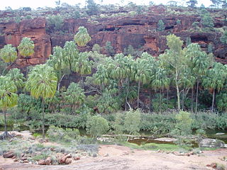
San Felipe Creek is a stream in Imperial and San Diego Counties of California. It arises in the Volcan Mountains of San Diego County 33°11′57″N116°37′35″W, and runs eastward, gathering the waters of most of the eastern slope of the mountains and desert of the county before it empties into the Salton Sea. It is probably the last remaining perennial natural desert stream in the Colorado Desert region. In 1974, the San Felipe Creek Area was designated as a National Natural Landmark by the National Park Service.
Palm Canyon Wash is an arroyo and tributary ephemeral stream or wash of the Whitewater River, in Riverside County, California.
Bull Canyon is a canyon at the top of Palm Canyon Wash, which is a tributary to the Whitewater River, in Riverside County, California. Bull Canyon and the creek of Palm Canyon Wash heads at 33°36′47″N116°33′23″W, at an elevation of 6,165 feet in the southern western slope of a ridge in the San Jacinto Mountains. The waters of the creek of Palm Canyon Wash are augmented by Bull Canyon Spring at 33°35′22″N116°33′24″W, at an elevation of 5,331 feet / 1,625 meters. The mouth of Bull Canyon is at an elevation of 4,508 feet / 1,374 meters at the head of head of Palm Canyon. The mouth of an unnamed creek flows north down from Vandeventer Flat into the head of Palm Canyon at its confluence with Palm Canyon Wash at 33°34′08″N116°31′43″W at an elevation of 4,460 feet.
Bull Canyon Spring is a spring in Bull Canyon, in the upper reach of Palm Canyon, in Riverside County, California. It is located at an elevation of 5,331 feet / 1,625 meters.