
Fort York is a historic site of military fortifications and related buildings located in the Fort York neighbourhood, west of downtown Toronto, Ontario, Canada. The fort was built by the British Army and Canadian militia troops in the late 18th and early 19th centuries, to defend the settlement and the new capital of the Upper Canada region from the threat of a military attack, principally from the newly independent United States. It was designated a National Historic Site in 1923. The City of Toronto designated the site, along with the nearby Fort York Armoury, as a Heritage Conservation District in 1985.
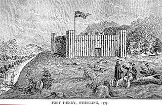
Fort Henry was a fort which stood about ¼ mile from the Ohio River in what is now downtown, Wheeling, West Virginia. The fort was originally known as Fort Fincastle and was named for Viscount Fincastle, Lord Dunmore, Royal Governor of Virginia. Later it was renamed for Patrick Henry, and was at the time located in Virginia. The fort was subject to two major sieges, two notable feats and other skirmishes.

In military science, a blockhouse is a small fortification, usually consisting of one or more rooms with loopholes, allowing its defenders to fire in various directions. It usually refers to an isolated fort in the form of a single building, serving as a defensive strong point against any enemy that does not possess siege equipment or, in modern times, artillery, air force and cruise missiles. A fortification intended to resist these weapons is more likely to qualify as a fortress or a redoubt, or in modern times, be an underground bunker. However, a blockhouse may also refer to a room within a larger fortification, usually a battery or redoubt.
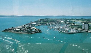
Fort Blockhouse is a military establishment in Gosport, Hampshire, England, and the final version of a complicated site. It is surrounded on three sides by water and provides the best view of the entrance to Portsmouth Harbour. It is unique in two respects - firstly, it was built over a number of centuries. Secondly, it is thought to be the oldest fortified position in the United Kingdom that is still in active military use.

Fort Hawkins was a fort built in 1806–1810 in the historic Creek Nation by the United States government under President Thomas Jefferson and used until 1824. Built in what is now Georgia at the Fall Line on the east side of the Ocmulgee River, the fort overlooked the sacred ancient earthwork mounds of the Ocmulgee Old Fields, now known as the Ocmulgee National Monument, and the Lower Creek Pathway. A trading settlement and later the city of Macon, Georgia, developed in the area prior to the construction of the fort, with Scottish fur traders being in the area as early as the 1650s. Later, the fort would become important to the Creek Nation, the United States, and the state of Georgia for economic, military, and political reasons.
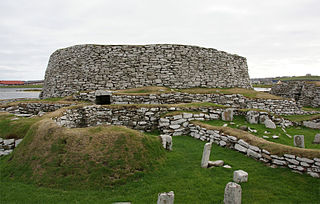
The Broch of Clickimin is a large, well-preserved but restored broch in Lerwick in Shetland, Scotland. Originally built on an island in Clickimin Loch, it was approached by a stone causeway. The broch is situated within a walled enclosure and, unusually for brochs, features a large "forework" or "blockhouse" between the opening in the enclosure and the broch itself. The site is maintained by Historic Scotland. According to its excavator, John R.C. Hamilton, there were several periods of occupation of the site: Late Bronze Age farmstead, Early Iron Age farmstead, Iron Age fort, broch period, and wheelhouse settlement.

Fort Presque Isle was a fort built by French soldiers in summer 1753 along Presque Isle Bay at present-day Erie, Pennsylvania, to protect the northern terminus of the Venango Path. It was the first of the French posts built in the Ohio Country, and was part of a line that included Fort Le Boeuf, Fort Machault, and Fort Duquesne.

Fort Simcoe was a United States Army fort erected in south-central Washington Territory to house troops sent to keep watch over local Indian tribes. The site and remaining buildings are preserved as Fort Simcoe State Park, located eight miles (13 km) west of modern White Swan, Washington, in the foothills of the Cascade Mountains.

Bayard's Cove Fort, also known historically as Berescove or Bearscore Castle, is an English 16th-century artillery blockhouse, built to defend the harbour entrance at Dartmouth in Devon. Constructed in the early part of the century, it had eleven gunports for heavy artillery and was intended to engage enemy vessels that broke past the external defences of the Dartmouth and Kingswear castles. It remained armed during the English Civil War, but was neglected in the 18th century and used for storage. The fort was restored in the late 19th century and is now managed by English Heritage and open to visitors.

Fort Halifax is a former British colonial outpost on the banks of the Sebasticook River, just above its mouth at the Kennebec River, in Winslow, Maine. Originally built as a wooden palisaded fort in 1754, during the French and Indian War, only a single blockhouse survives. The oldest blockhouse in the United States, it is preserved as Fort Halifax State Historic Site, and is open to the public in the warmer months. It was the first of three significant forts which the British built on the major rivers in the Northeast to cut off the native water ways to the ocean. The blockhouse was declared a National Historic Landmark and added to the National Register of Historic Places in 1968.
Fort Yamhill was an American military fortification in what became the state of Oregon. Built in 1856 in the Oregon Territory, it remained an active post until 1866. The Army outpost was used to provide a presence next to the Grand Ronde Agency Coastal Reservation. Several officers stationed at the United States Army post prior to the American Civil War would later serve as generals in that war.

The Tellico Blockhouse was an early American outpost located along the Little Tennessee River in Vonore, Monroe County, Tennessee. Completed in 1794, the blockhouse operated until 1807 with the purpose of keeping the peace between nearby Overhill Cherokee towns and early Euro-American settlers in the area in the wake of the Cherokee–American wars. The Tellico Blockhouse was the site where several treaties were negotiated in which the Cherokee were induced to cede large portions of land in Tennessee and Georgia. During this period, the blockhouse was the site of official liaisons between the United States government and the Cherokee.

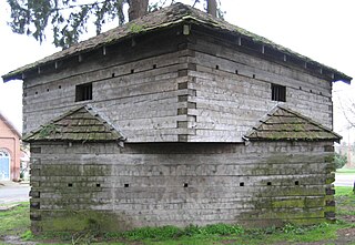
Blockhouse No. 1, colloquially known as The Blockhouse, is a small fort in the northern part of Central Park, in Manhattan, New York City, and is the second oldest structure in the park, aside from Cleopatra's Needle. It is located on an overlook of Manhattan schist, with a clear view of the flat surrounding areas north of Central Park. Finished in 1814, the fort was part of a series of fortifications in northern Manhattan, which originally also included three fortifications in what was then called Harlem Heights, now known as Morningside Heights. The fort is the last remaining fortification from these defenses. Frederick Law Olmsted and Calvert Vaux, the designers of Central Park, treated Blockhouse No. 1 as a picturesque ruin, romantically overrun with vines and Alpine shrubbery.

Fort Kent State Historic Site is a Maine state park in the town of Fort Kent, Maine. Located at the confluence of the Fish and Saint John Rivers, it includes Fort Kent, the only surviving American fortification built during border tensions with neighboring New Brunswick known as the Aroostook War. The park features an original log blockhouse, which is open for visits in the summer. The fort was added to the National Register of Historic Places in 1969 and declared a National Historic Landmark in 1973.

Fort Howe was built by the British during the American Revolution shortly after the American Siege of Saint John (1777), to protect Saint John from further American raids. The 18th and 19th century British Army fortification is built in present-day New Brunswick, at the mouth of the St. John River where it empties into the Bay of Fundy. The site of the fort is now located within the city of Saint John. Fort Howe includes a replica of the blockhouse that once stood at Fort Howe. It is located approximately 250 metres to the northeast of the original structure.

Huxter Fort is an iron age fortification on the island of Whalsay, in the Shetland islands of Scotland, dating to around 300 BC. It is on an islet in the Loch of Huxter, connected to the shore by a causeway.

The East and West Blockhouses were Device Forts built by King Henry VIII in 1539 to protect the harbour of Milford Haven in Wales. The two blockhouses were positioned on either side of the Milford Haven Waterway in the villages of Angle and Dale respectively, overlooking the sea. The East Blockhouse was never completed, but the remains were reused as a defensive site in the Second World War. The West Blockhouse was described by contemporaries as forming a round tower with gunports, but it was demolished when West Blockhouse Fort was built on the same site in the 19th century.

Gravesend Blockhouse was an artillery fortification constructed as part of Henry VIII's Device plan of 1539, in response to fears of an imminent invasion of England by France and the Holy Roman Empire. It was built at Gravesend in Kent along a strategic point along the River Thames and was operational by 1540. A two-storey, D-shaped building built from brick and stone, it had a circular bastion overlooking the river and gun platforms extending out to the east and west. It functioned in conjunction with Tilbury Fort on the other side of the river, and was repaired in 1588 to deal with the threat of Spanish invasion, and again in 1667 when the Dutch navy raided the Thames. A 1778 report recommended alterations to the blockhouse and its defences, leading to the remodelling of the gun platforms and the construction of the new, larger New Tavern Fort alongside it. In the 1830s the government decided to rely entirely on the newer fort and the old blockhouse was demolished in 1844. Its remains were uncovered in archaeological excavations between 1975 and 1976.

West Blockhouse Fort is a mid-19th century coastal artillery fort at West Blockhouse Point, a rocky headland near Dale, Pembrokeshire, to the west of Milford Haven in Wales.


