Related Research Articles
The Appalachian Trail, also called the A.T., is a hiking trail in the Eastern United States, extending almost 2,200 miles (3,540 km) between Springer Mountain in Georgia and Mount Katahdin in Maine, and passing through 14 states. The Appalachian Trail Conservancy claims the Appalachian Trail to be the longest hiking-only trail in the world. More than three million people hike segments of the trail each year.
Patten is a small town in Penobscot County, Maine, United States. At the 2020 census, the population was 881. The village of Patten is in the northeastern part of the town.

Millinocket is a town in Penobscot County, Maine, United States. The population was 4,114 at the 2020 census.

Mount Monadnock, or Grand Monadnock, is a mountain in the towns of Jaffrey and Dublin, New Hampshire. It is the most prominent mountain peak in southern New Hampshire and is the highest point in Cheshire County. It lies 38 miles (61 km) southwest of Concord and 62 miles (100 km) northwest of Boston. At 3,165 feet (965 m), Mount Monadnock is nearly 1,000 feet (305 m) higher than any other mountain peak within 30 miles (48 km) and rises 2,000 feet (610 m) above the surrounding landscape. Monadnock's bare, isolated, and rocky summit provides expansive views. It is known for being featured in the writings of Ralph Waldo Emerson and Henry David Thoreau.
The Penobscot are an Indigenous people in North America from the Northeastern Woodlands region. They are organized as a federally recognized tribe in Maine and as a First Nations band government in the Atlantic provinces and Quebec.

Mount Katahdin is the highest mountain in the U.S. state of Maine at 5,269 feet (1,606 m). Named Katahdin, which means "Great Mountain", by the Penobscot Native Americans, it is within Northeast Piscataquis, Piscataquis County, and is the centerpiece of Baxter State Park. It is a steep, tall massif formed from a granite intrusion weathered to the surface. The flora and fauna on the mountain are typical of those found in northern New England.

The Penobscot River is a 109-mile-long (175 km) river in the U.S. state of Maine. Including the river's West Branch and South Branch increases the Penobscot's length to 264 miles (425 km), making it the second-longest river system in Maine and the longest entirely in the state. Its drainage basin contains 8,610 square miles (22,300 km2).

The Allagash River is a tributary of the Saint John River, approximately 65 miles (105 km) long, in northern Maine in the United States. It drains in a remote and scenic area of wilderness in the Maine North Woods north of Mount Katahdin. The name "Allagash" comes from the Abenaki language, a dialect of the Algonquin languages, spoken by the Penobscot Tribe. The word, /walakéskʸihtəkʸ/, means "bark stream".
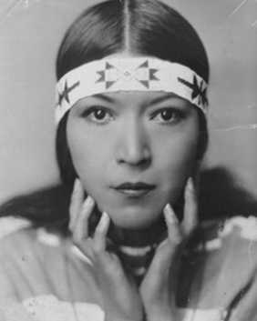
Mary Nelson Archambaud, best known by her stage name Molly Spotted Elk, was a Penobscot Indian dancer, actress, and writer who was born on the Penobscot Indian Island Reservation, in Maine, U.S.

Scouting in Maine dates back to the creation of the Katahdin Area Council in 1920 and has continued prominently to the present day.

The North Maine Woods is the northern geographic area of the state of Maine in the United States. The thinly populated region is overseen by a combination of private individual and private industrial owners and state government agencies, and is divided into 155 unincorporated townships within the NMW management area. There are no towns or paved roads.

North Brother is a mountain located in Baxter State Park, Piscataquis County, Maine. North Brother is flanked to the northeast by Fort Mountain, and to the southwest by South Brother; collectively the two are called "The Brothers."

Hamlin Peak is a 4,756-foot (1,450 m) mountain located in Baxter State Park in Piscataquis County, Maine. Hamlin Peak is a northern spur of the greater Mount Katahdin massif and is flanked to the south by Baxter Peak, and to the north by the Howe Peaks. Since it rises nearly 500 feet (150 m) above the col joining it to the higher Baxter Peak, Hamlin Peak qualifies as a four-thousand footer based on the topographic prominence criterion used by the Appalachian Mountain Club, and is ranked as the second-highest peak in Maine.
Doubletop Mountain is a mountain located in Piscataquis County, Maine, in Baxter State Park. According to Fannie Hardy Eckstorm, the mountain's Indigenous name was Psinskihegan-I-Outop. Psinskihegan means notch and I-Outop means head. in 1828 in the Survey of Maine, Moses Greenleaf called the mountain a variation Chinskihegan or Outop. It eventually became Doubletop, named for its two peaks.
Chesuncook Lake is a reservoir in Piscataquis County, Maine, within the North Maine Woods. The lake was formed by the damming of the West Branch Penobscot River by dams built in 1835, 1903, and 1916 respectively. It is approximately 22 miles (35 km) long and 1–4 miles wide, with a surface area of 25,183 acres (101.91 km2) and a maximum depth of 150 feet (46 m). It is the third-largest body of fresh water in Maine.

The Pemadumcook Chain of Lakes are a set of large lakes in north-central Maine in the United States.

Bellefield Boiler Plant, also known as "The Cloud Factory" from its nickname's use in Michael Chabon's 1988 debut novel The Mysteries of Pittsburgh, is a boiler plant located in Junction Hollow between the Carnegie Institute of Pittsburgh and Carnegie Mellon University in the Oakland district of Pittsburgh, Pennsylvania.

Nobscot Hill is a USGS name for a high point in Middlesex County, Massachusetts with many public hiking trails, and the hill is located in Framingham and Sudbury. At the summit are various radio towers and a fire tower. Below the summit of Nobscot Hill is the Nobscot Scout Reservation which includes Tippling Rock, a popular viewing location. Surrounding the hill are other large parks and parcels of conservation land, including the Nobscot Conservation Land, Callahan State Park, the Sudbury Weisblatt Conservation Land, and Wittenborg Woods, which are connected by various hiking trails, including the Bay Circuit Trail.

Black Cap Mountain is a 1,020 foot (310 m) mountain in Penobscot County, Maine, United States. The mountain is 5 miles (8.0 km) southeast of Eddington, Maine, and the Penobscot River. It is accessible from Maine Route 46, near its intersection with The Airline.

Katahdin Woods and Waters National Monument is a U.S. national monument spanning 87,563 acres (137 sq mi) of mountains and forestland in northern Penobscot County, Maine, including a section of the East Branch Penobscot River. The monument is located on the eastern border of Maine's Baxter State Park. Native animals include moose, bobcats, bald eagles, salmon, and Canada lynx.
References
- ↑ Official Website of the Penawahpskewi. (n.d.). Official Website of the Penawahpskewi. Retrieved October 17, 2014, from http://www.penobscotnation.org/
- ↑ Pinkham, Steven R. (2009). Mountains of Maine : intriguing stories behind their names (1st ed.). [Camden, ME]: Down East. ISBN 9780892727889. OCLC 297145691.
- ↑ Thoreau, Henry David (1848). Kataadn. Archived from the original on August 1, 2013. Retrieved March 8, 2013.