
Pioneer Island is part of the Severnaya Zemlya group in the Russian Arctic. It measures 1,527 km2 (590 sq mi) in area. The island was discovered by Georgy Ushakov and Nikolay Urvantsev during their 1930-32 expedition.
Arbizu is a village and municipality in the province and autonomous community of Navarre, northern Spain, neighbouring Etxarri-Aranatz. Its traditional "fiesta" falls on June 24, St. John's day, and is noted for the feast held in the main square.
Bishop River Provincial Park is a provincial park in the Pacific Ranges of the Coast Mountains on the Mainland of British Columbia, Canada, located southwest of and adjoining Ts'yl-os Provincial Park."Bishop River Park". BC Geographical Names. It lies along the upper course of the Bishop River, the main tributary of the Southgate River, from the Bishop's source at the western side of the Lillooet Icecap to midway along its course above its confluence with the Southgate. The park is 19,947 ha. in size. There are no roads or trails in the park although a forest service road from Waddington Harbour at the head of Bute Inlet leads up the Southgate to within a few miles of the park boundary.

Dores de Campos is a Brazilian municipality. It is about 40 kilometers from São João del Rey at BR-265. About 30% of active people work in its principal factory: Marluvas.

The Biosphere Reserve of Ñacuñan is located in the Mendoza Province, Argentina. It is a composed of three main geomorphological areas.

Charrua is a municipality in the state of Rio Grande do Sul, Brazil. As of 2020, the estimated population was 3,252.
Nova Alvorada is a municipality in the state of Rio Grande do Sul, Brazil. As of 2020, the estimated population was 3,663.
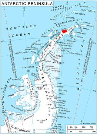
Sabine Glacier is a 13.5 km long glacier on the north side of Detroit Plateau, flowing from Mount Bris and Tsarevets Buttress northwards along the east slopes of Korten Ridge, and terminating at the sea in Jordanoff Bay on Davis Coast in Graham Land, Antarctica. Captain Henry Foster gave the name "Cape Sabine" in 1829 to a feature lying southeast of Cape Kater but it has not been possible to identify that cape. This toponym preserves the early use of Sabine in this area. Sir Edward Sabine (1788-1883), English astronomer and geodesist, was a member of the committee which planned the 1829 voyage of Foster in the Chanticleer.

McFarlane Strait is a strait lying between Greenwich Island and Livingston Island, in the South Shetland Islands off Antarctica. It is 24 kilometres (13 nmi) long and 3 kilometres (1.6 nmi) wide. The name appears on an 1822 chart by Captain George Powell, a British sealer, and is now well established in international usage.
The Caroaebe River is a river of Roraima state in northern Brazil, near the equator.

Comandante Fontana is an Argentinian city, located in Chaco Province in northern Argentina.
Puerto Lavalle is a village and municipality in Chaco Province in northern Argentina.

Larroque is a city in the Entre Ríos Province, in north-eastern Argentina. It is located on the South of the province, between Gualeguay and Gualeguaychú. It has a population of 6,451 according to the 2010 Census.
Boulding Ridge is the ridge separating Todd Glacier and McClary Glacier on the west side of Graham Land. It was named by the UK Antarctic Place-Names Committee for Richard A. Boulding, British Antarctic Survey surveyor at Stonington Island, 1965–68.

The Brugmann Mountains, rising to 805 metres (2,600 ft), are steep and rugged on the east slopes but are icecapped and descend gently toward the west, extending in a northeast–southwest arc along the east side of Liège Island, in the Palmer Archipelago. Their principal peaks are Mount Vesalius, Pavlov Peak, Mishev Bluff, Mount Kozyak, Vazharov Peak and Balkanov Peak.

Caraquet Rock is a rock lying nearly 4 nautical miles (7 km) west-southwest of Bell Point, off the west part of King George Island in the South Shetland Islands. It was named by the UK Antarctic Place-Names Committee in 1960 for the sealing vessel Caraquet from Liverpool, which visited the South Shetland Islands in 1821–22.

Whitecloud Glacier is a glacier which flows northward between Klokotnitsa Ridge on the east and Tsarevets Buttress on the west to discharge into Charcot Bay just west of Almond Point, Trinity Peninsula. Named by United Kingdom Antarctic Place-Names Committee (UK-APC) in 1960. The name is descriptive of cloud conditions that prevailed at the time of Falkland Islands Dependencies Survey (FIDS) survey of the area in 1948.
Dobson Dome is a prominent snow-covered, dome-shaped mountain 950 metres (3,120 ft) high between Rohss Bay and Croft Bay, in the northern portion of James Ross Island. It was surveyed by the Falkland Islands Dependencies Survey of 1958–61, and it was named by the UK Antarctic Place-Names Committee for Alban Dobson (1885–1962), a British civil servant who was Secretary of the International Whaling Commission from 1949–59 and President of the International Council for the Exploration of the Sea from 1952–55.