
The North American plate is a tectonic plate containing most of North America, Cuba, the Bahamas, extreme northeastern Asia, and parts of Iceland and the Azores. With an area of 76 million km2 (29 million sq mi), it is the Earth's second largest tectonic plate, behind the Pacific plate.

The South American plate is a major tectonic plate which includes the continent of South America as well as a sizable region of the Atlantic Ocean seabed extending eastward to the African plate, with which it forms the southern part of the Mid-Atlantic Ridge.
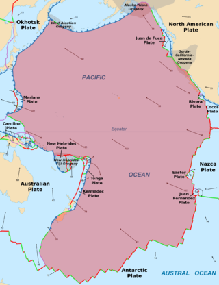
The Pacific plate is an oceanic tectonic plate that lies beneath the Pacific Ocean. At 103 million km2 (40 million sq mi), it is the largest tectonic plate.

The Cocos plate is a young oceanic tectonic plate beneath the Pacific Ocean off the west coast of Central America, named for Cocos Island, which rides upon it. The Cocos plate was created approximately 23 million years ago when the Farallon plate broke into two pieces, which also created the Nazca plate. The Cocos plate also broke into two pieces, creating the small Rivera plate. The Cocos plate is bounded to the northeast by the North American plate and the Caribbean plate. To the west it is bounded by the Pacific plate and to the south by the Nazca plate.

The Trans-Mexican Volcanic Belt, also known as the Transvolcanic Belt and locally as the Sierra Nevada, is an active volcanic belt that covers central-southern Mexico. Several of its highest peaks have snow all year long, and during clear weather, they are visible to a large percentage of those who live on the many high plateaus from which these volcanoes rise.
The East Pacific Rise (EPR) is a mid-ocean rise, at a divergent tectonic plate boundary, located along the floor of the Pacific Ocean. It separates the Pacific plate to the west from the North American plate, the Rivera plate, the Cocos plate, the Nazca plate, and the Antarctic plate. It runs south from the Gulf of California in the Salton Sea basin in Southern California to a point near 55°S130°W, where it joins the Pacific-Antarctic Ridge (PAR) trending west-south-west towards Antarctica, near New Zealand. Much of the rise lies about 3,200 km (2,000 mi) off the South American coast and reaches a height about 1,800–2,700 m (5,900–8,900 ft) above the surrounding seafloor.

The Caribbean plate is a mostly oceanic tectonic plate underlying Central America and the Caribbean Sea off the northern coast of South America.
The Galápagos hotspot is a volcanic hotspot in the East Pacific Ocean responsible for the creation of the Galápagos Islands as well as three major aseismic ridge systems, Carnegie, Cocos and Malpelo which are on two tectonic plates. The hotspot is located near the Equator on the Nazca Plate not far from the divergent plate boundary with the Cocos Plate. The tectonic setting of the hotspot is complicated by the Galápagos triple junction of the Nazca and Cocos plates with the Pacific plate. The movement of the plates over the hotspot is determined not solely by the spreading along the ridge but also by the relative motion between the Pacific plate and the Cocos and Nazca plates.
The Galápagos triple junction (GTJ) is a geological area in the eastern Pacific Ocean several hundred miles west of the Galápagos Islands where three tectonic plates – the Cocos plate, the Nazca plate, and the Pacific plate – meet. It is an unusual type of triple junction in which the three plates do not meet at a simple intersection. Instead, the junction includes two small microplates, the Galápagos microplate and the northern Galápagos microplate, caught in the junction, turning synchronously with respect to each other and separated by the Hess Deep rift.

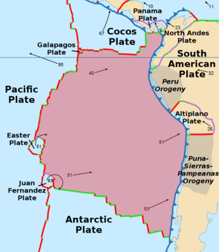
The Panama plate is a small tectonic plate (microplate) that exists between two actively spreading ridges and moves relatively independently of its surrounding plates. The Panama plate is located between the Cocos plate and the Nazca plate to the south and the Caribbean plate to the north. Most of its borders are convergent boundaries, including a subduction zone to the west. It consists, for the most part, of the countries of Costa Rica and Panama.
The 2002 Burica earthquake occurred on off the coast of Panama. It had a magnitude of 6.5. The epicenter was located off the southeastern coast of Burica Peninsula, close to the Costa Rica–Panama border. Some homes collapsed and at least 11 people were reported injured, both in Panama and in Costa Rica. The strongest intensity reached VII in Puerto Armuelles, Panama. It was felt with III (Weak) to IV (Light) around San Jose, Costa Rica. Shops in the center of Puerto Armuelles suffered from loss such as fallen merchandise and broken window glass. This earthquake occurred along the Panama Fracture Zone.

The Pacific Ocean evolved in the Mesozoic from the Panthalassic Ocean, which had formed when Rodinia rifted apart around 750 Ma. The first ocean floor which is part of the current Pacific plate began 160 Ma to the west of the central Pacific and subsequently developed into the largest oceanic plate on Earth.

The Malpelo plate is a small tectonic plate (microplate) located off the coasts west of Ecuador and Colombia. It is the 57th plate to be identified. It is named after Malpelo Island, the only emerged part of the plate. It is bounded on the west by the Cocos plate, on the south by the Nazca plate, on the east by the North Andes Plate, and on the north by the Coiba plate, separated by the Coiba transform fault (CTF). This microplate was previously assumed to be part of the Nazca plate. The Malpelo plate borders three major faults of Pacific Colombia, the north to south striking Bahía Solano Fault in the north and the Naya-Micay and Remolino-El Charco Faults in the south.
The Coiba plate is a small tectonic plate (microplate) located off the coasts south of Panama and northwestern Colombia. It is named after Coiba, the largest island of Central America, just north of the plate offshore southern Panama. It is bounded on the west by the Cocos plate, on the south by the Malpelo plate, on the east by the North Andes plate, and on the north by the Panama plate. This microplate was previously assumed to be part of the Nazca Plate, forming the northeastern tongue of the Nazca plate together with the Malpelo plate. Bordering the Coiba plate on the east are the north–south striking Bahía Solano Fault and east of that, the Serranía de Baudó, an isolated mountain chain in northwestern Chocó, Colombia.
The geology of Costa Rica is part of the Panama Microplate, which is slowly moving north relative to the stable Caribbean Plate.

At 02:10 PM local time (UTC-5) on 28 January 2020, an earthquake with a magnitude of 7.7 struck the north side of the Cayman Trough, north of Jamaica and west of the southern tip of Cuba, with the epicenter being 80 miles east-southeast of Cayman Brac, Cayman Islands, and 83 miles north of Montego Bay, Jamaica. Schools in Jamaica, as well as corporate and public buildings in Miami, were evacuated after shaking was experienced in parts of the U.S. state of Florida, a region not typically thought of in-relation to seismic activity. Light shaking was also reported on the Yucatán Peninsula in Mexico. The quake was the largest seismic event in the Caribbean since 1946. A tsunami warning for the Caribbean Sea was initially issued by the Pacific Tsunami Warning Center, later being withdrawn.
The Malpelo Ridge is an elevated part of Nazca Plate off the Pacific coast of Colombia. It is a faulted chain of volcanic rock of tholeiitic composition. The Malpelo Ridge may have originated simultaneously as Carnegie Ridge, and thus represent an old continuation of Cocos Ridge. It is thought to have acquired it present position due to tectonic movements along the Panama Fracture Zone.

The Chile Ridge, also known as the Chile Rise, is a submarine oceanic ridge formed by the divergent plate boundary between the Nazca plate and the Antarctic plate. It extends from the triple junction of the Nazca, Pacific, and Antarctic plates to the Southern coast of Chile. The Chile Ridge is easy to recognize on the map, as the ridge is divided into several segmented fracture zones which are perpendicular to the ridge segments, showing an orthogonal shape toward the spreading direction. The total length of the ridge segments is about 550–600 km.