This article relies largely or entirely on a single source .(September 2021) |

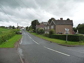
Pandy is a hamlet in Monmouthshire, south east Wales, United Kingdom.
This article relies largely or entirely on a single source .(September 2021) |
Pandy is a hamlet in Monmouthshire, south east Wales, United Kingdom.
Pandy is 5 miles (8 km) north of Abergavenny on the A465 road to Hereford immediately north of Llanfihangel Crucorney. The Wales–England border is one mile to the north, and the Offa's Dyke Path and Marches Way pass through the village.
The village of Pandy ranges from the Pandy watermill at Allt-yr-Ynys in the north to the edge of Lanfihangel Crucorney to the south. The fulling-mill at Pandy served the Llanover estate in the 17th century producing wool, which was turned into Welsh flannel. Pandy is the Welsh word for a fulling-mill.
The village was on a route used by the early railways; the Abergavenny to Hereford line still passes to the west. There was at one time the Grosmont tramroad as well, now demolished. Raymond Williams was born in a cottage next to Offa's Dyke where his father was a railway signalman on the Hereford to Abergavenny railway line.
The village was redeveloped in the Victorian era by a pioneering lady architect, Bernadette Rocher, who, in the 1870s, extended and reworked many of the older properties in local red sandstone. She is buried at the parish church at Oldcastle, Monmouthshire, a short distance to the northwest.

The village has no parish church, but has two Nonconformist chapels, one Baptist and one Presbyterian Church of Wales.
The village has several campsites and small caravan parks and two pubs. The housing is a mix of Victorian era cottages, farms and villas and some 1970s housing estates such as Wern Gifford.
The Black Mountains rise up to the west of the village, with the outlying Skirrid looming high over the village to the east.
Pandy has two hotels, the Park Hotel and Allt Yr Ynys Country Hotel.
Pandy railway station closed in 1958, with trains running through between Hereford and Abergavenny on the Welsh Marches Line.
The singer-songwriter MARINA lived in Pandy for most of her childhood, although she was born in Brynmawr. The socialist writer and academic Raymond Williams was also born in Pandy in 1921. [1]
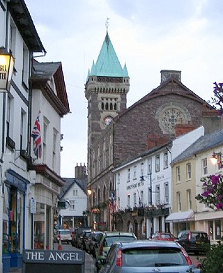
Abergavenny is a market town and community in Monmouthshire, Wales. Abergavenny is promoted as a Gateway to Wales; it is approximately 6 miles (10 km) from the border with England and is located where the A40 trunk road and the recently upgraded A465 Heads of the Valleys road meet.

Usk is a town and community in Monmouthshire, Wales, 10 miles (16 km) northeast of Newport. It is located on the River Usk, which is spanned by an arched stone bridge at the western entrance to the town. Usk Castle, above the town, overlooks the ancient crossing point. It developed as a small market town, with some industry including the making of Japanware, and with a notable prison built in 1841–42. In recent years Usk has become known for its history of success in Britain in Bloom competitions, winning the "Wales in Bloom" competition for 35 times in a row between 1982 and 2016. The resident population of the town in 2011 was 2,834, decreasing to roughly 2,600 in 2021. 6.8% of the population are recorded as being able to speak Welsh.
Llanvapley is a village in the community of Gobion Fawr, in Monmouthshire, south east Wales, United Kingdom. Llan has replaced the (earlier) Eglwys (1254). This village lies 4 miles north east of 2023’s Best Places to Live listed town, Abergavenny.

Llanfoist is a village near Abergavenny, in Monmouthshire, Wales, in the community of Llanfoist Fawr. Llanfoist derives from Ffwyst, an early Christian Welsh saint, although the anglicised version of the church patron is Saint Faith. The population was 1,228 in 2011.

The Black Mountains are a group of hills spread across parts of Powys and Monmouthshire in southeast Wales, and extending across the England–Wales border into Herefordshire. They are the easternmost of the four ranges of hills that comprise the Brecon Beacons National Park, and are frequently confused with the westernmost, which is known as the Black Mountain. The Black Mountains may be roughly defined as those hills contained within a triangle defined by the towns of Abergavenny in the southeast, Hay-on-Wye in the north and the village of Llangors in the west. Other gateway towns to the Black Mountains include Talgarth and Crickhowell. The range of hills is well known to walkers and ramblers for the ease of access and views from the many ridge trails, such as that on the Black Hill in Herefordshire, at the eastern edge of the massif. The range includes the highest public road in Wales at Gospel Pass, and the highest point in southern England at Black Mountain.

The Vale of Ewyas is the steep-sided and secluded valley of the River Honddu, in the Black Mountains of Wales and within the Brecon Beacons National Park. As well as its outstanding beauty, it is known for the ruins of Llanthony Priory, and for several noteworthy churches such as those at Capel-y-ffin and Cwmyoy. It is sometimes referred to as the "Llanthony Valley" as Llanthony is the village situated at the valley centre.

The Marches Way is a partially waymarked long-distance footpath in the United Kingdom. It runs for 351 kilometres (218 mi) through the Welsh–English borderlands, traditionally known as the Welsh Marches, and links the cities of Chester in the north and Cardiff in the south.

Llanvihangel Crucorney is a small village in the community (parish) of Crucorney, Monmouthshire, Wales. It is located 5 miles (8.0 km) north of Abergavenny and 18 miles (29 km) southwest of Hereford, England on the A465 road.

Llantilio Crossenny is a small village and much larger former community, now in the community of Whitecastle, in Monmouthshire, south east Wales, in the United Kingdom. It is situated between the two towns of Abergavenny and Monmouth on the B4233 road. The community included Penrhos, and Llanvihangel-Ystern-Llewern.

Llangattock Lingoed is a small rural village in Monmouthshire, south east Wales. It is located approximately five miles north of Abergavenny, between Abergavenny and Grosmont, a few miles south of the Wales-England border. Offa's Dyke Path passes through the village. The village is near the Black Mountains and the Brecon Beacons National Park.

Llanthony is a village in the community of Crucorney on the northern edge of Monmouthshire, South East Wales, United Kingdom.

Oldcastle is a small village in Monmouthshire, south east Wales.
The Beacons Way is a waymarked long distance footpath in the Brecon Beacons National Park, Wales. It is a linear route which runs for 99 miles (159 km) east to west through the National Park, and passes many of the most important landmarks and mountain peaks in the mountain range. It also includes a few of the towns in the park as well as popular attractions such as Carreg Cennen Castle near Llandeilo at the western end of the path.
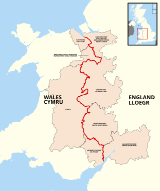
The England–Wales border, sometimes referred to as the Wales–England border or the Anglo-Welsh border, runs for 160 miles (260 km) from the Dee estuary, in the north, to the Severn estuary in the south, separating England and Wales.

The River Gavenny or sometimes the Gavenny River is a short river in Monmouthshire in south Wales. It rises 1 mile (1.6 km) southwest of the village of Llanvihangel Crucorney from springs near Penyclawdd Court, supplemented by springs in Blaen-Gavenny Wood and tributary streams there and within the Woodland Trust-owned Great Triley Wood. It flows south for about 4 miles (6.4 km) to its confluence with the River Usk towards the eastern end of Castle Meadows at Abergavenny. The town derives its English-language name from the Gavenny's confluence with the River Usk. Of the buildings on the banks of the river, the Gothic Decorated style church of St Teilo at Llantilio Pertholey is especially notable. Parts of the church date from the thirteenth century with multiple additions since. Blaengavenny Farm, the name of which signifies the 'head of the Gavenny', is a sixteenth-century farmhouse near the river's source.

Walterstone is a village and civil parish in Herefordshire, England, near the Welsh border and the Brecon Beacons National Park, 14 miles (23 km) south-west of Hereford. The parish had a population of 97 in the 2001 UK Census and is grouped with Craswall, Llanveynoe and Longtown to form Longtown Group Parish Council for administrative purposes.
Monmouth Cap is a hamlet in the north of the county of Monmouthshire, Wales. It stands to the north of the village of Grosmont, and to the south of the village of Pontrilas, just over the border in England.

Crucorney Welsh: Crucornau is a community in the county of Monmouthshire, Wales. It is the northernmost community in the county and covers the villages of Llanvihangel Crucorney, Pandy, Cwmyoy and Llanthony amongst others. The Vale of Ewyas comprises much of the northern part of the community, with the River Honddu running through Llanthony and Llanvihangel Crucorney, before turning northeast passing Pandy towards the River Monnow. The 2011 population was 1,201.
Pandy railway station was a railway station which served the Monmouthshire village of Pandy. It was located on the Welsh Marches Line between Hereford and Abergavenny.

Llanvihangel railway station was a former station which served the Monmouthshire village of Llanvihangel Crucorney. It was located on the Welsh Marches Line between Hereford and Abergavenny.