
Équateur was one of the eleven provinces of the Democratic Republic of the Congo between 1966 and 2015, when it was split into the new, smaller Équateur province, as well as the Tshuapa, Mongala, Nord-Ubangi and Sud-Ubangi provinces.
The Kwilu River is a major river that originates in Angola and flows north through Bandundu Province in the Democratic Republic of the Congo (DRC) to the city of Bandundu, where it joins the Kwango River just before this stream enters the Kasai River. In the DRC the river flows past the towns of Gungu, Kikwit, Bulungu, Bagata, Rutherfordia and Bandundu. Lusanga, formerly Leverville, lies at the location where the Kwenge River joins the Kwilu, between Kikwit and Bulungu.
The Ulindi River is a tributary of the Lualaba River in the Democratic Republic of the Congo (DRC). There is a proposal to build a hydroelectric power plant on the river to power a gold mining project.

Lake Tumba is a shallow lake in northwestern part of the Democratic Republic of the Congo, in the Bikoro Territory of the Province of Équateur.

Bosobolo is a small town in Nord-Ubangi Province of northern Democratic Republic of the Congo. As of 2009 it had an estimated population of 16,397. It is the administrative center of Bosobolo territory.
Kungu is a town and capital of one of the four territories of Sud-Ubangi Province, Democratic Republic of the Congo. The Ubangi River forms the western boundary of Kungu Territory, separating it from the Republic of the Congo. The Ngiri River, which flows southward through the Ngiri Reserve, originates near the town of Kungu.
Kahemba is a territory of the Democratic Republic of the Congo. It is located in Kwango Province. Divisions are:
Bagata is a town in the Kwilu Province of the Democratic Republic of the Congo. It is the administrative headquarters of Bagata Territory, and is situated on the Kwilu River between Kikwit and Bandundu.
Kasongo Lunda is a town and seat of Kasongo Lunda Territory, in the Kwango Province of the Democratic Republic of the Congo. The town lies near the border with Angola to the east, here defined by the Kwango River. As of 2012 the town was estimated to have a population of 23,820.

Bas-Uele is one of the 26 provinces of the Democratic Republic of the Congo. Its capital is the town of Buta.

Haut-Uele is one of the 26 provinces of the Democratic Republic of the Congo. Its capital is Isiro. The district takes its name, which means "upper Uele" in French, from the Uele River.

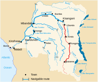
Tshopo is one of the 26 provinces of the Democratic Republic of the Congo. It is situated in the northeast of the country on the Tshopo River, for which it is named. Its capital is Kisangani.
Bas-Fleuve District is a district located in the Kongo Central province, in the Democratic Republic of the Congo. It includes the Tshela, Lukula and Seke-Banza territories.
Plateaux District is a former district located in the current Mai-Ndombe Province, effective no later than February 2009. However, the change was not implemented until 2015, and up until then it was part of the Bandundu Province.
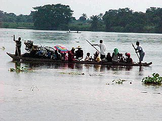
The Elila River is a tributary of the Lualaba River in the Democratic Republic of the Congo. It rises in Mwenga Territory of Sud-Kivu Province and flows west through Shabunda Territory and then Pangi Territory in Maniema Province, entering the Lualaba just downstream of Kindu.
Pangi Territory is an administrative area in Maniema Province of the Democratic Republic of the Congo. The headquarters is the town of Pangi.

The Lega people are an ethnic group of the Democratic Republic of the Congo. In 1998 their population was about 250,000.
Djugu is a town in the Ituri Province of the Democratic Republic of the Congo. It is the administrative headquarters of Djugu Territory. As of 2012 the population was estimated at 28,061.
Bomongo is a town in the Équateur Province of the Democratic Republic of the Congo, the headquarters of Bomongo Territory. It lies on the west bank of the Ngiri River. Bomongo is the only town in the Ngiri Reserve, a sparsely populated region of swamp forest between the Ubangi and Congo rivers.
Bolobo Territory is an administrative region of Mai-Ndombe Province of the Democratic Republic of the Congo. The headquarters is the town of Bolobo. The territory lies on the east side of the Congo River, opposite the Republic of the Congo.
