Panoramic Hill, Oakland/Berkeley, California

Last updated

Panoramic Hill
Panoramic Hill 1.jpg
A house in Panoramic Hill
Location map Oakland.png
Red pog.svg
Panoramic Hill
Location within Oakland and Berkeley
Coordinates: 37°52′10″N122°14′56″W / 37.86948°N 122.248845°W / 37.86948; -122.248845
Country United States
State California
County Alameda
Cities Oakland and Berkeley
Panoramic Hill
NRHP reference No. 05000424 [1]
Added to NRHPOctober 21, 2005

Panoramic Hill is a residential neighborhood of the cities of Berkeley and Oakland, California defined by the homes along and within the access corridor defined by Panoramic Way.

Contents

Geography

The Panoramic Hill Neighborhood is located at the eastern edge of the city of Berkeley, southeast of the University of California campus, and situated at the northwestern foot of the Claremont Canyon Regional Preserve and the Claremont Hills. The neighborhood is bounded by Piedmont Avenue, the Clark Kerr Campus and the main University of California campus. The eastern half of this neighborhood is in the City of Oakland. It includes the streets of Panoramic Way, Mosswood Road, Panoramic Place (Berkeley), Panoramic Place (Oakland), Arden Road, Dwight Place, and Dwight Way. The neighborhood is approximately 0.258 square miles. [2]

Traffic

Panoramic Way is a very steep and narrow public road with numerous sharp turns and curves serving approximately 500 residents. Traffic can become difficult during rush hours, waste collection times or when construction and service vehicles are present. Emergency vehicles do regular patrols of the area to test their ability to access all residents in case of emergency. Where the street is only wide enough for one car, the car facing downhill must yield to the car facing uphill, as required by California Motor Vehicle Code. [3]

Parking

Because of the Panoramic Hill Neighborhood's situation between both the city of Berkeley and the city of Oakland it is regulated by both cities with parking regulation. The Berkeley portion of the hill has a 2-hour limit and is patrolled between 8 AM and 7 PM, Monday through Saturday, excluding holidays. Residents can acquire a "K" parking permit. Parking in the Oakland portion of the hill is also limited to 2 hours and is patrolled between 8 AM and 6 PM, Monday through Friday. Residents can acquire an "L" parking permit.

Panoramic Walking Path

Orchard Lane Panoramic Hill 5.jpg
Orchard Lane
Signs Frequent The Hill To Indicate How to Get Down and "Off The Hill." Steps panoramic way berkeley.jpg
Signs Frequent The Hill To Indicate How to Get Down and "Off The Hill."

Panoramic Hill is home to a series of maintained walking paths and staircases that lead, on and off the road, halfway up the hill where they intersect a series of fire trails that lead into the hills. Each set of steps is treated as its own walking byway and is therefore named and well marked. Signs are also placed around the hill indicating the direction of the closest set of 'steps off the hill' for visitors who become lost among the trees, architecture, and windy roads. The lower steps are called Orchard Lane, and split at Panoramic Way (the vehicle road) and Mosswood Path a pedestrian pathway covered by antique red woods. Arden Steps are the penultimate set of steps in the series and are severely steep. Arden Steps and Arden Path meet at the cul-de-sac of Arden Road where Arden Path finishes the series with a sloping path and a final series up two dozen wooden steps.

A plaque at the entrance to the Orchard Lane and thus the bottom of the hill is inscribed:

"One of Berkeley's romantic treasures, Orchard Lane is the formal pedestrian entrance to the Panoramic Hill residential neighborhood. The walk and Classical staircase, complete with pillars, balustrades, concrete benches, and an overhanging bower of trees, was built by Warren Cheney, who developed Panoramic Hill. In 1904 Cheney, the former editor of the literary magazine The Californian, purchased the land. In 1909 he commissioned Henry Atkins to design the stairway that still links residences with the University and town and other walkways that climb the hill."

Berkeley Historical Plaque Project 1998

History

A staircase in Panoramic Hill Panoramic Hill 3.jpg
A staircase in Panoramic Hill

Established in 1904 by Warren Cheney, the Panoramic Hill neighborhood of Berkeley and Oakland enjoys a robust history.

Panoramic Hill was added to the National Register of Historic Places as a historic district in 2005. [1]

Fire Trail

The upper and lower Jordan trails are fire trails through the University of California ecological area. The university is required to keep the trails open for emergency vehicle access.

Points of interest

The Berkeley Historical Society frequently conducts walking tours of Panoramic Hill and its surrounding trails and views.

Architecture

Panoramic Hill Panoramic Hill 2.jpg
Panoramic Hill

"The quality of this area depends not so much on its individual buildings, though there are many fine structures by Berkeley's most important designers, but upon the survival of a complete neighborhood that provides a background for these buildings. Thus, the individual designs of Coxhead, Morgan, or Maybeck do not appear as museum pieces in a glass case, divorced of context, but convey the image and atmosphere of the intellectual and cultural milieu which aspired at the turn of the century to be the Athens of the West."

John Beach [4]

Panoramic Hill features the architecture of Julia Morgan, Ernest Coxhead, John Hudson Thomas, Walter Ratcliff, William Wurster, Walter Steilberg, Frank Lloyd Wright, Mark Mack, Harwell Hamilton Harris and Bernard Maybeck [5] as well as a wide variety of craftsman built homes each uniquely adapting to the geography and encapsulating the view. The Panoramic Hill neighborhood is frequently a part of architectural walking tours in Berkeley. [6] [7] Panoramic Hill was named "Berkeley's Most Romantic Neighborhood" by the Berkeley Architectural Heritage Association. [8]

See also

Related Research Articles

<span class="mw-page-title-main">Claremont Canyon Regional Preserve</span>

Claremont Canyon Regional Preserve is a small regional park mainly located in the city of Oakland, California, and administered by the East Bay Regional Park District. The park is named for the canyon in which it is situated, Claremont Canyon, out of which Claremont Creek flows on its way to its confluence with Temescal Creek. Originally, the canyon was named Harwood's Canyon, and then later as Telegraph Canyon. The name was changed to Claremont by a developer of the nearby Claremont district.

<span class="mw-page-title-main">Telegraph Avenue</span> Street in Oakland and Berkeley, California

Telegraph Avenue is a street that begins, at its southernmost point, in the midst of the historic downtown district of Oakland, California, and ends, at its northernmost point, at the southern edge of the University of California, Berkeley campus in Berkeley, California. It is approximately 4.5 miles (7 km) in length.

<span class="mw-page-title-main">Bernard Maybeck</span> American architect

Bernard Ralph Maybeck was an American architect in the Arts and Crafts Movement of the early 20th century. He was an instructor at University of California, Berkeley. Most of his major buildings were in the San Francisco Bay Area.

<span class="mw-page-title-main">Forest Hill, San Francisco</span> Neighborhood of San Francisco

Forest Hill is a neighborhood in San Francisco, California. Forest Hill is one of eight master-planned residence parks in San Francisco. Forest Hill is located near the middle of the City of San Francisco, southeast of the Inner Sunset and northeast of West Portal. Boundaries are roughly Seventh Avenue/Laguna Honda Boulevard to the north and east, Taraval Street to the south, and 14th Avenue to the west.

<span class="mw-page-title-main">Montclair, Oakland, California</span> Neighborhood of Oakland in Alameda, California, United States

Montclair is a hillside neighborhood in Oakland, California, United States. Montclair is located along the western slope of the Oakland Hills from a valley formed by the Hayward Fault to the upper ridge of the hills.

<span class="mw-page-title-main">Uptown Pittsburgh</span> Neighborhood of Pittsburgh in Allegheny County, Pennsylvania, United States

Uptown or The Bluff is a neighborhood in the city of Pittsburgh, Pennsylvania to the southeast of the city's Central Business District. It is bordered in the north by the Hill District and located across the Monongahela River from South Side. The predominant area zip code is 15219.

<span class="mw-page-title-main">Northside, Berkeley, California</span> Neighborhood of Berkeley in Alameda, California, United States

Northside is a principally residential neighborhood in Berkeley, California, located north of the University of California, Berkeley campus, east of Oxford Street, and south of Cedar Street. There is a small shopping area located at Euclid and Hearst Avenues, at the northern entrance to the university. The Graduate Theological Union is located one block west of Euclid Avenue, in an area nicknamed Holy Hill. The north fork of Strawberry Creek runs southwestward across Northside, mostly culverted under buildings and pavement, to the campus.

<span class="mw-page-title-main">Willis Polk</span> American architect (1867–1924)

Willis Jefferson Polk was an American architect, best known for his work in San Francisco, California. For ten years, he was the West Coast representative of D.H. Burnham & Company. In 1915, Polk oversaw the architectural committee for the Panama–Pacific International Exposition (PPIE).

<span class="mw-page-title-main">Temescal, Oakland, California</span> Neighborhood of Oakland in Alameda, California, United States

Temescal is one of the oldest neighborhoods in Oakland, California, located in North Oakland, and centered on Telegraph Avenue. The neighborhood derives its name from Temescal Creek, a significant watercourse in the city.

Oakland City Center is an office, shopping and hotel complex in Downtown Oakland, Oakland, California. The complex is the product of a redevelopment project begun in the late 1950s. It covers twelve city blocks between Broadway on the east, Martin Luther King Jr. Way on the west, Frank H. Ogawa Plaza on 14th Street on the north side of the complex and the Oakland Convention Center and Marriott Hotel extend south to 10th Street. An hourly parking garage is located beneath the complex's shopping mall. The mall features an upscale fitness and racquet club, in addition to numerous take-out restaurants and other stores. The complex is served by the 12th Street/Oakland City Center BART station.

<span class="mw-page-title-main">La Loma Park</span> Neighborhood of Berkeley, California, United States of America

La Loma Park is a neighborhood and tract of land located in the Berkeley Hills section of the city of Berkeley, California in the San Francisco Bay Area. The land had been the property of Captain Richard Parks Thomas, a veteran of the American Civil War and Berkeley businessman. Today, it is entirely a residential area The Spanish word loma means "rise/low hill". Although hilly throughout, its average elevation is about 614 feet (187 m).

<span class="mw-page-title-main">Downtown Berkeley, Berkeley, California</span> Neighborhood of Berkeley in Alameda, California, United States

Downtown Berkeley is the central business district of the city of Berkeley, California, United States, around the intersection of Shattuck Avenue and Center Street, and extending north to Hearst Avenue, south to Dwight Way, west to Martin Luther King Jr. Way, and east to Oxford Street. Downtown is the mass transit hub of Berkeley, with several AC Transit and UC Berkeley bus lines converging on the city's busiest BART station, as well as the location of Berkeley's civic center, high school, and Berkeley City College.

<span class="mw-page-title-main">César Chávez Park</span> City park of Berkeley, California

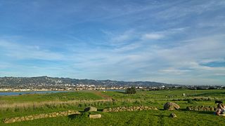
César Chávez Park is a 90 acres (36 ha) city park of Berkeley, California named after César Chávez. It can be found on the peninsula on the north side of the Berkeley Marina in the San Francisco Bay and is adjacent to Eastshore State Park.

<span class="mw-page-title-main">Robert Sibley Volcanic Regional Preserve</span> Nature preserve in the San Francisco Bay Area

Robert Sibley Volcanic Regional Preserve is located in the Oakland Hills of the East Bay region of the San Francisco Bay Area, California. The park is part of the East Bay Regional Parks District (EBRPD), covers 928 acres (3.76 km2), and lies east of Oakland, partly in Alameda County and partly in Contra Costa County. It can be entered from Oakland via Skyline Boulevard, or from Contra Costa County via Old Tunnel Road.

<span class="mw-page-title-main">J. Mora Moss House</span> Building in California, United States

J. Mora Moss House is a boldly romantic Carpenter Gothic style Victorian home located within Mosswood Park in Oakland, California. It was built in 1864, bought by Oakland in 1912 and documented by the Historic American Buildings Survey in 1960 at which point it was pronounced "One of the finest, if not the finest, existing examples of Gothic architecture of French and English influence as adapted to wood frame domestic architecture to be found in the East Bay Area, and possibly in Northern California." The building was named Oakland Heritage Landmark #6 on January 7, 1975. It is one of five historic homes owned by the City of Oakland and currently serves as an office and storage space of the Oakland Parks and Recreation department.

<span class="mw-page-title-main">Lilian Bridgman</span> American architect

Lilian "Lillie" Belle Bridgman (1866–1948) was an American architect, educator, writer, and scientist. After working first as a science teacher and writer, she changed her profession in mid-life and followed her dream of becoming an architect.

<span class="mw-page-title-main">Temple of Wings</span> Historic house in Berkeley, California

Temple of Wings is a historic Greco-Roman style private estate located at 2800 Buena Vista Way in the La Loma Park neighborhood of Berkeley, California. The main structure was designed by Bernard Maybeck and completed by A. Randolph Monro. It was originally designed as an open-air private home dedicated to modern and contemporary dance. It has been listed by the city as a Berkeley Landmark since January 6, 1992, and is listed in the California State Historic Resources Inventory. It is sometimes known as the Temple of Winds, the Boynton House, and the Charles C. Boynton House.

<span class="mw-page-title-main">Rose Walk (Berkeley, California)</span> Historic site in Berkeley, California, U.S.

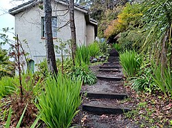
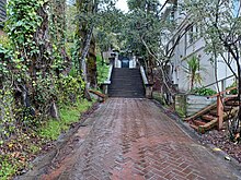
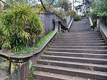
The Rose Walk, formerly known as Rose Street, is a historic pathway with landscaping designed by architect Bernard Maybeck in the La Loma Park neighborhood of Berkeley, California, U.S.. It is located in the 2500 block of Rose Walk, between Euclid Avenue and Le Roy Avenue. It is listed by the city as a Berkeley Landmark, since December 15, 1975. The Rose Walk has a historical marker erected in 1998 by Berkeley Historical Plaque Project.

References

  1. 1 2 "National Register Information System". National Register of Historic Places . National Park Service. July 9, 2010.
  2. "Panoramic Hill neighborhood in Berkeley, California (CA), 94704 subdivision profile - real estate, apartments, condos, homes, community, population, jobs, income, streets".
  3. "California Driver Handbook - Laws and Rules of the Road". www.dmv.ca.gov. Archived from the original on August 20, 2008.
  4. "BAHA :: 2005 Spring House Tour".
  5. "Home". berkeleyheritage.com.
  6. "BAHA :: 41 Berkeley Walking Tours".
  7. "BAHA :: Panoramic Hill House Tour Photo Album".
  8. "Berkeley Panoramic Hill - Red Oak Realty". www.redoakrealty.com. Archived from the original on August 31, 2007.

37°52′10″N122°14′56″W / 37.86948°N 122.248845°W / 37.86948; -122.248845