
The Battle of Mossy Creek was a minor battle of the American Civil War, occurring on December 29, 1863, in Jefferson County, Tennessee.

The East Bay River in Florida is a 15-mile-long (24 km) river located in Santa Rosa and Okaloosa counties. It flows from east to west, forming near Hurlburt Field, and empties into the eastern portion of East Bay (Florida) near the towns Holley and Navarre. The river forms part of the southern boundary of Eglin Air Force Base.
The Jim Edgar Panther Creek State Fish and Wildlife Area (JEPC) is a conservation area located within Cass County in the U.S. state of Illinois. It is 16,550 acres (6,698 ha) in size. A mix of plowed upland prairie and Panther Creek woodlands, the site is managed by the Illinois Department of Natural Resources. It is drained by the Sangamon River. It is named for former Governor of Illinois Jim Edgar.

Tetrahedron Provincial Park is a provincial park located within the territory of the shíshálh Nation on the southern Sunshine Coast, in British Columbia, Canada. The park was created in 1995 thanks to the efforts of a collective of NGOs who came together to protect the headwaters of the Chapman Creek and Gray Creek Community Watersheds from commercial logging activities.
The LPGA State Farm Classic was a women's professional golf tournament on the LPGA Tour. It was played annually from 1976 to 2011 in the Springfield, Illinois metropolitan area. From 1976 through 2006, the tournament was held at The Rail Golf Course. In 2007 it moved to Panther Creek Country Club.
Panther Mountain is one of the Catskill High Peaks, located in the Town of Shandaken in Ulster County, New York. At approximately 3,720 feet (1,130 m) in elevation, it is the 18th highest in the range. A combination of factors has led some geologists to believe the mountain is on the site of an ancient meteorite impact crater.
Panther Creek High School is a public high school located at 6770 McCrimmon Parkway in Cary, North Carolina, United States. As part of the Wake County Public School System, the school operates on a 4x4 block schedule like other public high schools in the region.

Panther Falls are a series of waterfalls in Banff National Park, Alberta, Canada. It is developed on Nigel Creek and its waters originate in Nigel Pass, between the slopes of Cirrus Mountain and Nigel Peak in the Parker Ridge of the Canadian Rockies.

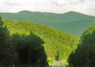
Panther Creek State Park is a state park in Morristown, Tennessee, United States. It is located prominently on the shore of Cherokee Lake, an impoundment of the Holston River, via the Cherokee Dam. The western terminus of Tennessee State Route 342 is located inside the park. The route connects the park to U.S. Route 11E. The park has an area of approximately 1,444 acres (6 km2).

Panther Peak is a mountain located in Essex County, New York. The mountain is part of the Santanoni Mountains of the Adirondacks. Panther Peak is flanked to the west by Couchsachraga Peak, and to the south by Santanoni Peak.
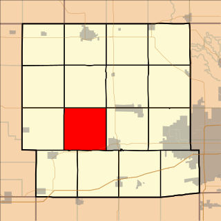
Colfax Township is a township in Dallas County, Iowa, United States. As of the 2000 census, its population was 403.
Panther Wildlife Management Area, located along Panther Creek in southwestern McDowell County, West Virginia. It is 7,820 acres (3,160 ha) in size.

The Panther Creek Wind Farm in Big Spring, Texas, United States consists of 305 wind turbines and has an installed capacity of 457.5 megawatts, making it one of the ten largest wind farms in the United States. Phases I and II of the wind farm became operational early in 2009, with the completion of the third and final phase in September 2009. The projects are located in Howard, Sterling and Glasscock Counties. The wind farm can now generate enough wind power to supply 135,000 Texan homes.
Panther is an unincorporated community in McDowell County, West Virginia, United States. Panther is located along the Tug Fork, 4.5 miles (7.2 km) west-northwest of Iaeger. Panther has a post office with ZIP code 24872.

Pisgah Mountain or Pisgah Ridge is a ridgeline running 12.5 miles (20.1 km) from Tamaqua to Jim Thorpe, Pennsylvania. It is oriented north-northeast to south-southwest, and its north-side valley is followed by U.S. Route 209 from river gap to river gap. The ridge is a succession of peaks exceeding 1,440 feet (438.9 m) rising 300 to 540 feet above the boroughs of Lansford, Coaldale, and Tamaqua in the Panther Creek valley. The highest point on Pisgah Mountain is at 1,611 feet (491 m) in the borough of Summit Hill, which sits atop the ridge. Near Summit Hill was the "Sharpe Mountain" (peak) where in 1791 Phillip Ginter is documented as having discovered anthracite, leading to the formation of the Lehigh Coal Mine Company. In 1818 the Lehigh Coal Company took over the mines, and the mining camp gradually became a settlement and grew into Summit Hill.
Nesquehoning Mountain or Nesquehoning Ridge is a 15–17-mile-long (24–27 km) coal bearing ridge dividing the waters of Lehigh Valley to the north from the Schuylkill River valley and the several near parallel ridgelines of the Ridge-and-valley Appalachians barrier range all local members of which run generally WSW-ENE in the greater overall area.
Panther Mountain is a mountain located in Central New York of New York near Fly Creek, New York and Schuyler Lake, New York. The east side of Panther Mountain drains into Fly Creek and the west side drains into Oaks Creek and Canadarago Lake.