The Corris Railway is a narrow gauge preserved railway based in Corris on the border between Merionethshire and Montgomeryshire in Mid-Wales.

Merionethshire or Merioneth is one of thirteen historic counties of Wales, a vice county and a former administrative county.
The A487, officially the Fishguard to Bangor Trunk Road, is a trunk road in Wales that follows the coast from Haverfordwest, Pembrokeshire, in the south, to Bangor, Gwynedd, in the north.

Machynlleth is a market town, community and electoral ward in Powys, Wales and within the historic boundaries of Montgomeryshire. It is in the Dyfi Valley at the intersection of the A487 and the A489 roads. At the 2001 Census it had a population of 2,147, rising to 2,235 in 2011. It is sometimes referred to colloquially as Mach.
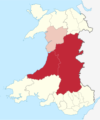
Mid Wales or Central Wales is a region of Wales, encompassing its midlands, in-between North Wales and South Wales. The Mid Wales Regional Committee of the Senedd covered the unitary authority areas of Ceredigion and Powys and the area of Gwynedd that had previously been the district of Meirionnydd. A similar definition is used by the BBC. The Wales Spatial Plan defines a region known as "Central Wales" which covers Ceredigion and Powys.
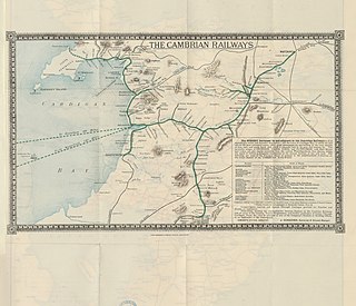
The Cambrian Railways owned 230 miles (370 km) of track over a large area of mid Wales. The system was an amalgamation of a number of railways that were incorporated in 1864, 1865 and 1904. The Cambrian connected with two larger railways with connections to the northwest of England via the London and North Western Railway, and the Great Western Railway for connections between London and Wales. The Cambrian Railways amalgamated with the Great Western Railway on 1 January 1922 as a result of the Railways Act 1921. The name is continued today in the route known as the Cambrian Line.

Pennal is a village and community on the A493 road in southern Gwynedd, Wales, on the north bank of the River Dyfi, near Machynlleth.

Aberllefenni is a village in the south of Gwynedd, Wales. It lies in the historic county of Merionethshire/Sir Feirionnydd, in the valley of the Afon Dulas, and in the Community of Corris.
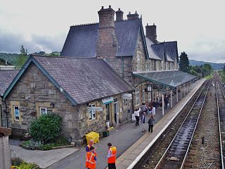
Machynlleth railway station is on the Cambrian Line in mid-Wales, serving the town of Machynlleth. It was built by the Newtown and Machynlleth Railway (N&MR) and subsequently passed into the ownership of the Cambrian Railways, the Great Western Railway, Western Region of British Railways and London Midland Region of British Railways. It is notable in that there are 22 miles (35 km) separating this station and Caersws, the longest distance between two intermediate stations in Wales.

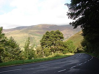
Corris is a village in the county of Gwynedd, Wales, about 4.5 miles (7 km) north of the town of Machynlleth. The village lies on the west bank of the Afon Dulas, around that river's confluence with the Afon Deri. Its railway station is the headquarters and museum of the Corris Railway, a preserved narrow gauge railway.

Dwyfor Meirionnydd is a constituency of the House of Commons of the Parliament of the United Kingdom. The seat was created by the Welsh Boundary Commission for the 2010 general election, and replaced the old north Wales seat of Meirionnydd Nant Conwy. Dwyfor Meirionnydd is bordered to the north by Arfon and Aberconwy. The same boundaries were used for the Dwyfor Meirionnydd Welsh Assembly constituency in the 2007 Welsh Assembly election.

Ffridd Gate was a station on the Corris Railway in Merioneth, Wales, UK. It was built at the level crossing over the B4404 road to Llanwrin, near the hamlet of Fridd. A small hamlet also grew up around the station and a nearby (pre-existent) toll-house. The hamlet and former station are near to the confluence of the Afon Dulas and the River Dyfi, around 2+1⁄4 miles (3.6 km) west of the village of Llanwrin and 1 mile (1.6 km) north of the town of Machynlleth.

Corris Uchaf is a village lying in the south of the Snowdonia National Park in Gwynedd, Wales. The slate quarries that surround Corris Uchaf are its most prominent feature.

Arthog is a village, post town and community in the Meirionnydd area in Gwynedd, north Wales including the villages of Fairbourne and Friog. It is located on the A493, approximately 8 miles (13 km) west of Dolgellau, and had a population of 1,010 in 2001, increasing slightly to 1,031 at the 2011 census.

The Abercorris quarry was a slate quarry worked between the mid-1840s and the early 1950s. It was located at Corris Uchaf about 5 miles north of Machynlleth, in Gwynedd, north-west Wales. The quarry was connected to the Corris Railway via the Upper Corris Tramway which carried its products to the Cambrian Railways at Machynlleth for distribution. It worked the Narrow Vein.

The A493 is a road located on the west coast of mid Wales and connects Dolgellau to Machynlleth via the coast, avoiding Corris and Cross Foxes.
The Aberystwyth & District Football League is a football league in Mid Wales, sitting at the fifth level of the Welsh football league system.
The Upper Corris Tramway was a 2 ft 3 in gauge horse-worked tramway that connected the slate quarries around the villages of Corris and Corris Uchaf with the Corris Railway at Maespoeth Junction. It was just over 1.8 miles (2.9 km) long.

The Llwyngwern quarry was a slate quarry in Wales that opened by 1828 and continued working until about 1950. The quarry is located on the western flank of Mynydd Llwyn-gwern.

Cwm Hengae is a valley that runs roughly north-west from the village of Aberllefenni in Wales. The Afon Llefenni river runs along the valley and several slate quarries occupy the valley sides. The Roman road Sarn Helen ran along the valley, connecting Aberllefenni with Dolgellau.
