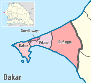
Dakar region is the smallest and most populated region of Senegal, encompassing the capital city of the country, Dakar, and all its suburbs along the Cap Vert peninsula, Africa's most westerly point.
Thiès is a region of western Senegal. The capital is also called Thiès.

The 14 regions of Senegal are subdivided into 46 departments and 103 arrondissements and by collectivités locales which elect administrative officers.
Mbacké is a city and urban commune in central Senegal, located 190 km (118 mi) east of Dakar. It is the capital of an administrative department in the Diourbel region. Along with the nearby city of Touba, Mbacké forms an urban conurbation whose population currently stands at 1,222,275, making it Senegal's second largest agglomeration. It is connected to Dakar and Touba by the N3 road.

Tivaouane or Tivawan is a city and urban commune located in the Thiès Region of Senegal.

Nioro du Rip department is one of the 46 departments of Senegal, located in the Kaolack region.

Lat Jor Ngoné Latir Jop was a nineteenth-century damel (king) of Cayor, a Wolof state that is today in Sénégal. He is today a national hero of Senegal for his resistance to French colonialism.
Mamadu Diakhou Bâ, also known as Maba Jahou Bah, Ma Ba Diakhu, Ma Ba Diakho Ba, Ma Ba Jaaxu, Mabba Jaxu Ba, was a Muslim leader in West Africa during the 19th century. He was a disciple of the Tijaniyya Sufi brotherhood and became the Almami of Saloum.

Nioro du Rip is a town and urban commune in the south-west of Sénégal, situated about 60 km (37 mi) to the south-west of Kaolack and 27 km (17 mi) from the border with The Gambia.
Émile Pinet-Laprade (1822–1869) was a French governor of Senegal.
Badème is a village in the rural community of Nyassia, Nyassia Arrondissement, Ziguinchor Department in the Ziguinchor Region of south-west Senegal, near the border with Guinée-Bissau.

Women in Senegal have a traditional social status as shaped by local custom and religion. According to 2005 survey, the female genital mutilation prevalence rate stands at 28% of all women in Senegal aged between 15 and 49.
Maad a Signig Kumba Ndoffene Famak Joof was the King of Sine in modern-day Senegal. Maad a Sinig means king of Sine. He ruled from 1853 until his death on 23 August 1871. He was the son of Maad Souka Ndela Joof and Lingeer Gnilane Jogoy Joof. His father – Maad Souka Ndela came from The Royal House of Semou Njekeh Joof founded by Maad Semou Njekeh Joof in the early 18th century, which was the third and last Royal House of Joof family of Sine and Saloum. His paternal family ruled three Kingdoms : Sine, Kingdom of Saloum and previously the Kingdom of Baol. They descended from Maad Ndaah Njemeh Joof the 13th century King of Lâ (Laah) in Baol.
Fandène is a small village in Senegal about 7 km from Thiès. It is inhabited by the Serer people.

The Battle of Fandane-Thiouthioune, also known as the Battle of Somb or the Battle of Somb-Tioutioune, occurred on 18 July 1867. It was a religious war between the Serer people and the Muslim Marabouts in 19th-century Senegal and the Gambia, but it also had a political and economic dimension to it: vendetta and empire-building. Fandane, Thiouthioune and Somb were part of the pre-colonial Serer Kingdom of Sine, now part of independent Senegal.
Somb is a town in Senegal situated in the west of the country.
This is a timeline of the history and development of Serer religion and the Serer people of Senegal, The Gambia and Mauritania. This timeline merely gives an overview of their history, consisting of calibrated archaeological discoveries in Serer countries, Serer religion, politics, royalty, etc. Dates are given according to the Common Era. For a background to these events, see Roog, Serer religion, Serer creation myth, Serer prehistory, Lamane, States headed by Serer Lamanes, Serer history and Serer people.
The Battle of Logandème was an uprising led by the Serer King Maad a Sinig Kumba Ndoffene Famak Joof, king of Sine, against the French Empire. The battle took place at Logandème which was a part of Sine at the time. The battle was also a revenge attack against the Serer people after their resounding victory against France at the Battle of Djilass on 13 May 1859. It was the first time that France decided to employ cannonball in the Senegambia.

The Historical Museum of Senegal in Gorée is a museum attached to the Institut fondamental d'Afrique noire (IFAN) and located on the island of Gorée, in the bay of Dakar, Senegal. The museum is dedicated to showing and commemorating the different stages of Senegal's history from ancient times to the country's independence.
A tata or tata somba is a historic type of fortification used throughout West Africa. The word is applied to the wall itself as well as the elite living spaces within it for the ruler of the tata and his court. It can also designate the defenses around a major city or other military center. The term 'tata' derives from the Mandinka language but has used across a wide area, roughly corresponding to the former Mali Empire, since at least the 16th century.
