
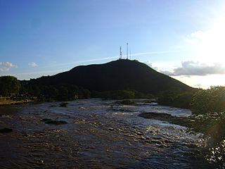
The São Francisco River or Rio São Francisco is a river in Brazil. With a length of 2,914 kilometres (1,811 mi), it is the longest river that runs entirely in Brazilian territory, and the fourth longest in South America and overall in Brazil. It used to be known as the Opara by the indigenous people before colonisation, and is today also known as Velho Chico.

Cattleya is a genus of orchids from Costa Rica south to Argentina. The genus is abbreviated C in trade journals.

The Buranhém River - also known as Rio do Peixe - is a watercourse flowing through the states of Minas Gerais (20km) and Bahia (128km), in Brazil. It ends its course at the Atlantic Ocean just by the city of Porto Seguro. The city holds a distinctive place in Brazilian history as in 1500 it was the first landing point of Portuguese navigators commanded by Pedro Álvares Cabral, who discovered Brazil.

The Carinhanha River is a river of Bahia and Minas Gerais states in eastern Brazil.

The De Contas River is a river of Bahia state in eastern Brazil. In Portuguese, it is sometimes erroneously called "Rio das Contas". It is the main river of the hydrographic basin named after him.

The Itanhém River is a river of Bahia state in eastern Brazil. The Itanhém River, also called the Alcobaça River, cuts through the Bahia municipalities of Alcobaça and Itanhém, and flows into Barra do Itanhém Beach in Alcobaça. It is born from the Machacalis in the municipality of Fronteira dos Vales, state of Minas Gerais, and runs from west to east to the mouth of Alcobaça in Bahia, where it flows into the Atlantic Ocean. This river used to be the main access of the white colonizers originating from the Vila de Caravelas to the sertão baiano. The most common fish found in the river Itanhém are: cordata, traíra, piaú, catfish and cascudo. But there are some crustaceans like pitu and shrimp.
The Jucurucu River is a river of Bahia and Minas Gerais states in eastern Brazil.
The Mucuri River is a river of Bahia and Minas Gerais states in eastern Brazil.

Rio Verde Grande is a river of Minas Gerais state in eastern Brazil, that forms the boundary with Bahia state in its lowest reaches. It is a tributary of the São Francisco River.
Rio Verde Pequeno It is a tributary of the Rio Verde, it demarcates the border between the States of Minas Gerais and Bahia in eastern Brazil.
The Salabro River is a river of Minas Gerais and Goiás states in central Brazil.
The Camanducaia River is a river which rises in Minas Gerais and flows through São Paulo state in southeastern Brazil.
The Rio do Peixe is a river of São Paulo and Minas Gerais states in southeastern Brazil. It is a tributary of the Mojiguaçu River.

Carinhanha is a municipality in the state of Bahia in the North-East region of Brazil. Carinhanha covers 2,529.45 km2 (976.63 sq mi), and has a population of 29,864 with a population density of 12 inhabitants per square kilometer. It is located on the banks of the Rio São Francisco and the Carinhanha River, which also forms the border of the state of Minas Gerais.

Feira da Mata is a municipality in the state of Bahia in the North-East region of Brazil. Feira da Mata covers 1,176.105 km2 (454.097 sq mi), and has a population of 5,911 with a population density of 5 inhabitants per square kilometer. It was originally part of Carinhanha, but became an independent municipality in 1989.

The Kamakã languages are a small family of extinct Macro-Jê languages of Bahía near Brazil's Atlantic coast. The attested Kamakã languages are:
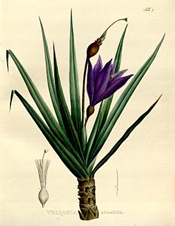
Vellozia is a plant genus in the family Velloziaceae, established in 1788.
BR-367 is a federal highway that begins in Santa Cruz Cabrália, Bahia and ends in Gouveia, Minas Gerais. The highway connects Porto Seguro in Bahia and Araçuaí and Diamantina in Minas Gerais.
