Related Research Articles
The Geography of Guyana comprises the physical characteristics of the country in Northern South America and part of Caribbean South America, bordering the North Atlantic Ocean, between Suriname and Venezuela, with a land area of approximately 214,969 square km. The country is situated between 1 and 9 north latitude and between 56 and 62 west longitude. With a 459 km (285 mi)-long Atlantic coastline on the northeast, Guyana is bounded by Venezuela on the west, Brazil on the west and south, and Suriname on the east.
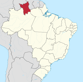
Roraima is one of the 26 states of Brazil. Located in the country's North Region, it is the northernmost and most geographically and logistically isolated state in Brazil. It is bordered by the state of Pará to the southeast, Amazonas to the south and west, Venezuela to the north and northwest, and Guyana to the east.
Chestatee is an unincorporated community in northeastern Forsyth County, Georgia, United States, due west of the confluence of the Chestatee River into the Chattahoochee River. Originally a Cherokee settlement, it was called Atsunsta Ti Yi.
The Pacaraima or Pakaraima Mountains are a mountain range primarily in southwestern Guyana, and into northern Brazil and eastern Venezuela.

The Ireng River forms part of Guyana's western border with Brazil. It flows through the valleys of the Pakaraima Mountains for most of its length. It is the only major river in Guyana which flows from North to South, up to its confluence into the Takutu River. It is one of the northernmost tributaries of the Amazon river system.

The Elk River is a tidal tributary of the Chesapeake Bay on the Eastern Shore of Maryland and on the northern edge of the Delmarva Peninsula. It is about 15 miles (24 km) long. As the most northeastern extension of the Chesapeake Bay estuary, it has served as one entrance to the Chesapeake & Delaware Canal since the 19th century. The canal and river now serve as one boundary of the Elk Neck Peninsula. The river flows through Cecil County, Maryland, with its watershed extending into New Castle County, Delaware and Chester County, Pennsylvania. Elkton, the county seat of Cecil County, is located at its head. Its total watershed area is 143 square miles (370 km2), with 21 square miles (54 km2) of open water, so its watershed is 15% open water. It is south and east of the North East River, and north of the Sassafras River.
The Orinduik Falls lie on the Ireng River, a highland river that thunders over steps and terraces of red jasper on the border of Guyana and Brazil before merging with the Takutu River and into Brazil to join the Amazon River.
The Arraia River is a river of Roraima state in northern Brazil.
The Auari River is a river of Roraima state in northern Brazil.
The Caju River is a river of Roraima state in northern Brazil.
The Caroaebe River is a river of Roraima state in northern Brazil, near the equator.
The Maracani River is a river of Roraima state in northern Brazil.
The Miang River is a river of Roraima state in northern Brazil.
The Surumu River is a river of Roraima state in northern Brazil.
The Cataract River is a 1.9-mile-long (3.1 km) river in Newton Township, Mackinac County in the Upper Peninsula of the U.S. state of Michigan.
Glenland is an unincorporated community in Pittsylvania County, in the U.S. state of Virginia.
Charrette Creek is a stream in Warren County in the U.S. state of Missouri. It is a tributary of the Missouri River. The headwaters of the stream are at 38°43′54″N91°00′29″W and the confluence with the Missouri is at 38°33′36″N90°59′59″W. The stream enters the Missouri River floodplain two miles west of Marthasville and joins the Missouri about four miles to the east just north of Washington.
The Ailã River is a river of Roraima state in northern Brazil. It is located in Monte Caburaí, in the municipality of Uiramutã. Its source is the northernmost point of Brazil.
References
Coordinates: 3°59′59″N60°56′28″W / 3.99972°N 60.94111°W