Cumberland is a historic county of North West England that had an administrative function from the 12th century until 1974. It is bordered by the historic counties of Northumberland to the northeast, County Durham to the east, Westmorland to the southeast, Lancashire to the south, and the Scottish counties of Dumfriesshire and Roxburghshire to the north. It formed an administrative county from 1889 to 1974 and now forms part of Cumbria.

Cumberland County is a county in the State of New South Wales, Australia. Most of the Sydney metropolitan area is located within the County of Cumberland.

For lands administrative purposes, New South Wales is divided into 141 counties, which are further divided into parishes. The counties were first set down in the Colony of New South Wales, which later became the Australian state of New South Wales.

Lands administrative divisions of Australia are the cadastral divisions of Australia for the purposes of identification of land to ensure security of land ownership. Most states term these divisions as counties, parishes, hundreds, and other terms. The eastern states of Queensland, New South Wales, Victoria, and Tasmania were divided into counties and parishes in the 19th century, although the Tasmanian counties were renamed land districts in the 20th century. Parts of South Australia (south-east) and Western Australia (south-west) were similarly divided into counties, and there were also five counties in a small part of the Northern Territory. However South Australia has subdivisions of hundreds instead of parishes, along with the Northern Territory, which was part of South Australia when the hundreds were proclaimed. There were also formerly hundreds in Tasmania. There have been at least 600 counties, 544 hundreds and at least 15,692 parishes in Australia, but there are none of these units for most of the sparsely inhabited central and western parts of the country.
Cumberland Boroughs was an electoral district of the Legislative Assembly in the Australian state of New South Wales from 1856 to 1859, consisting of the Cumberland County towns of Richmond, Windsor, Liverpool and Campbelltown, but not the surrounding rural areas, which were in Cumberland and Cumberland. The district was abolished in 1859, with Richmond and Windsor forming the new electorate of Windsor, Campbelltown was included in Narellan and Liverpool became part of Central Cumberland.

St James Parish, Cumberland is one of the 57 parishes of Cumberland County, New South Wales, a cadastral unit for use on land titles. It is one of the four small parishes in the Sydney city area, which is named after the Anglican church of St James, which was consecrated in 1824. The name St James is also used today for the railway station in the same area.
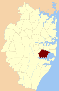
St George Parish is one of the 57 parishes of Cumberland County, New South Wales, a cadastral unit for use on land titles. It is bounded in the north by the Cooks River, in the west of Cox's Creek and Salt Pan Creek, and in the south by the Georges River.
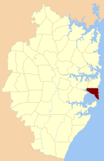
Botany Parish, Cumberland is one of the 57 parishes of Cumberland County, New South Wales, a cadastral unit for use on land titles. It contains the area to the north of Botany Bay and to the east of part of Cooks River. It includes the suburbs of La Perouse, Hillsdale, Banksmeadow and Maroubra. It also includes Sydney Airport. It roughly corresponds to the "South-Eastern Suburbs" of Sydney, which are sometimes counted as part of the Eastern Suburbs together with the suburbs in the Parish of Alexandria to the north.

Petersham Parish is one of the 57 parishes of Cumberland County, New South Wales, a cadastral unit for use on land titles. It is located to the south of Iron Cove, Rozelle Bay and the Parramatta River, and to the north of Cooks River. It includes the suburbs of Balmain, Leichhardt, Petersham, Newtown, Marrickville, Tempe, Glebe and St Peters. It roughly corresponds to the eastern half of the Inner West region, with the neighbouring Parish of Concord making up the western half.

Concord Parish is one of the 57 parishes of Cumberland County, New South Wales, a cadastral unit for use on land titles. It is located to the south of the Parramatta River between Homebush Bay and Iron Cove; and to the north of Cooks River. It includes the suburbs of Homebush, most of Strathfield, Burwood, Croydon, Concord, Canada Bay and Abbotsford. It covers the local government areas of City of Canada Bay and the Municipality of Burwood and most of the Municipality of Strathfield. It roughly corresponds to the western half of the Inner West region, with the neighbouring Parish of Petersham making up the eastern half.

St John Parish is one of the 57 parishes of Cumberland County, New South Wales, a cadastral unit for use on land titles. It is named after St John's Cathedral in Parramatta, New South Wales which opened in 1803, on which the civil parish is roughly centred. The parish is shaped like a "T", with the northern part stretching from Toongabbie to the western shore of Homebush Bay. The southern end is at Prospect Creek near Yennora. Woodville Road and Parramatta Road form the boundaries to the south-east. The Old Prospect Road is part of the boundary in the west.
Cumberland was an electoral district of the Legislative Assembly in the Australian state of New South Wales in outer western Sydney named after Cumberland County. It was created as a three-member electorate with the introduction of proportional representation in 1920, replacing Camden and Hawkesbury. It was abolished in 1927 and replaced by Hawkesbury, Nepean, and parts of Bankstown, Lakemba and Hornsby.
Members of the New South Wales Legislative Assembly who served in the first parliament of New South Wales held their seats from 1856 to 1858. </ref> The Speaker was Sir Daniel Cooper.
Parish of Gidley, is one of the 57 civil parishes of the County of Cumberland.
Parish of St Matthews, is one of the 57 civil parishes of the County of Cumberland, New South Wales.
The Parish of Rooty Hill, is a civil parish of Cumberland County in New South Wales, Australia.
The parish of Ham Common is one of the 57 civil parishes of the County of Cumberland, New South Wales.
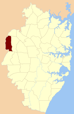
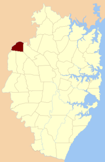
Parish of Nelson, is a civil parish of the County of Cumberland, north west of Sydney, Australia.
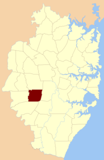
The Parish of Cabramatta is a civil parish of Cumberland County, a Cadastral division of New South Wales.

The Parish of Claremont, is a civil parish of the Cumberland County.