Parish of Nelson (Cumberland County)

Last updated

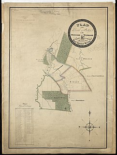
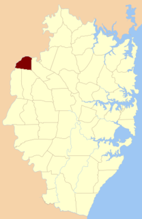
Parish of Nelson, is a civil parish of the County of Cumberland, [1] north west of Sydney, Australia.

Civil parish Territorial designation and lowest tier of local government in England

In England, a civil parish is a type of administrative parish used for local government, they are a territorial designation which is the lowest tier of local government below districts and counties, or their combined form, the unitary authority. Civil parishes can trace their origin to the ancient system of ecclesiastical parishes which historically played a role in both civil and ecclesiastical administration; civil and religious parishes were formally split into two types in the 19th century and are now entirely separate. The unit was devised and rolled out across England in the 1860s.

It is in the Land District of Windsor, and the parish is centered on the suburbs of Nelson, New South Wales, and Box Hill, New South Wales. [2]

Nelson, New South Wales Suburb of Sydney, New South Wales, Australia

Nelson is a suburb of Sydney, in the state of New South Wales, Australia 42 kilometres north-west of the Sydney central business district in the local government area of The Hills Shire. It is part of the Hills District.

Box Hill, New South Wales Suburb of Sydney, New South Wales, Australia

Box Hill is a suburb of Sydney, in the state of New South Wales, Australia. Box Hill is located 42 kilometres north-west of the Sydney central business district in the local government area of The Hills Shire and part of the Hills District region.

The parish is one of the oldest cadasteral divisions in Australia.

Australia Country in Oceania

Australia, officially the Commonwealth of Australia, is a sovereign country comprising the mainland of the Australian continent, the island of Tasmania, and numerous smaller islands. It is the largest country in Oceania and the world's sixth-largest country by total area. The neighbouring countries are Papua New Guinea, Indonesia, and East Timor to the north; the Solomon Islands and Vanuatu to the north-east; and New Zealand to the south-east. The population of 25 million is highly urbanised and heavily concentrated on the eastern seaboard. Australia's capital is Canberra, and its largest city is Sydney. The country's other major metropolitan areas are Melbourne, Brisbane, Perth, and Adelaide.

The dominant land use of the area is rural allotments; however, in 2017 the district was released of residential purposes and it is expected the within a few years the parish will be added to the urban sprawl of Western Sydney.

Urban sprawl Expansion of auto-oriented, low-density development in suburbs

Urban sprawl or suburban sprawl mainly refers to the unrestricted growth in many urban areas of housing, commercial development, and roads over large expanses of land, with little concern for urban planning. In addition to describing a particular form of urbanization, the term also relates to the social and environmental consequences associated with this development. In Continental Europe the term "peri-urbanisation" is often used to denote similar dynamics and phenomena, although the term urban sprawl is currently being used by the European Environment Agency. There is widespread disagreement about what constitutes sprawl and how to quantify it. For example, some commentators measure sprawl only with the average number of residential units per acre in a given area. But others associate it with decentralization, discontinuity, segregation of uses, and so forth.

Western Sydney is a major region of Sydney, New South Wales, Australia. It has a number of different definitions, although the one consistently used is the region composed of the nine local government authorities which are all members of the Western Sydney Regional Organisation of Councils (WSROC). The NSW Government's Office of Western Sydney uses the broader Greater Western Sydney definition to refer to the region. The region lies in the Cumberland Plain.

Related Research Articles

County of Cumberland, New South Wales Cadastral in New South Wales, Australia

Cumberland County is a county in the State of New South Wales, Australia. Most of the Sydney metropolitan area is located within the County of Cumberland.

Hills District Region in New South Wales, Australia

The Hills District is a general term for the north-western suburbs of Sydney, in the state of New South Wales, Australia. Situated within the Greater Western Sydney region, its constituent suburbs are generally located in the local government area of The Hills Shire; some parts of the Hornsby Shire, Blacktown and Parramatta Cities are generally given the title.

Nineteen Counties area of New South Wales colony to which European settlement was legally restricted from 1826 until 1861

The Nineteen Counties were the limits of location in the colony of New South Wales, Australia. Settlers were permitted to take up land only within the counties due to the dangers in the wilderness.

Cumberland was an electoral district of the Legislative Assembly in the Australian state of New South Wales from 1856 to 1859, in Cumberland County, which includes Sydney. It included all of the county north of Parramatta Road and the Great Western Highway, except for the urban electorates of Sydney (City), Sydney Hamlets, Parramatta and Cumberland Boroughs, which included Richmond and Windsor. It elected two members simultaneously, with voters casting two votes and the first two candidates being elected.

Lands administrative divisions of New South Wales Wikimedia list article

The lands administrative divisions of New South Wales refers to the 141 counties within the Colony of New South Wales, that later became the Australian state of New South Wales.

Lands administrative divisions of Australia

Lands administrative divisions of Australia are the cadastral divisions of Australia for the purposes of identification of land to ensure security of land ownership. Most states term these divisions as counties, parishes, hundreds, and other terms. The eastern states of Queensland, New South Wales, Victoria and Tasmania were divided into counties and parishes in the 19th century, although the Tasmanian counties were renamed land districts in the 20th century. Parts of South Australia (south-east) and Western Australia (south-west) were similarly divided into counties, and there were also five counties in a small part of the Northern Territory. However South Australia has subdivisions of hundreds instead of parishes, along with the Northern Territory, which was part of South Australia when the hundreds were proclaimed. There were also formerly hundreds in Tasmania. There have been at least 600 counties, 544 hundreds and at least 15,692 parishes in Australia, but there are none of these units for most of the sparsely inhabited central and western parts of the country.

Cumberland Boroughs was an electoral district of the Legislative Assembly in the Australian state of New South Wales from 1856 to 1859, consisting of the Cumberland County towns of Richmond, Windsor, Liverpool and Campbelltown, but not the surrounding rural areas, which were in Cumberland and Cumberland.

Parish of St James Cadastral in New South Wales, Australia

St James Parish, Cumberland is one of the 57 parishes of Cumberland County, New South Wales, a cadastral unit for use on land titles. It is one of the four small parishes in the Sydney city area, which is named after the Anglican church of St James, which was consecrated in 1824. The name St James is also used today for the railway station in the same area.

James Ruse Drive road in Sydney

The James Ruse Drive is a 6.7-kilometre-long (4.2 mi) urban highway located to the east and north of Parramatta, in western Sydney, New South Wales, Australia.

Parish of St Andrew Cadastral in New South Wales, Australia

St Andrew Parish, Cumberland is one of the 57 parishes of Cumberland County, New South Wales, a cadastral unit for use on land titles. It is one of the four small parishes in the Sydney city area, which is named after the church of St Andrew's. The parish was named while the church was still in the planning stages. The parish includes Pyrmont and the Darling Harbour area. It is bounded by Wattle Street in the south west, George Street in the south and east, and King Street in the north-east. It includes Town Hall railway station, which is on the eastern end of the parish.

Hundred of Sydney Cadastral in New South Wales, Australia

The Hundred of Sydney is a former lands administrative division for the city of Sydney. It was one of the thirteen hundreds in the County of Cumberland, which were published in the government gazette of May 27, 1835, and repealed on January 21, 1888. It included nine parishes ; the four small parishes in the Sydney city area: St Andrew, St James, St Lawrence and St Philip, as well as five larger parishes further away from the city: Concord, Petersham, Alexandria, Botany and St George. Its boundaries were the Parramatta River/Sydney Harbour to the north, Botany Bay/Georges River to the south, while the western boundary included part of Haslams Creek and Salt Pan Creek.

Electoral district of County of Cumberland

The Electoral district of County of Cumberland was an electorate of the New South Wales Legislative Council at a time when some of its members were elected and the balance were appointed by the Governor.

Parish of Gidley

Parish of Gidley, is one of the 57 civil parishes of the County of Cumberland.

Parish of St Matthew

Parish of St Matthews, is one of the 57 civil parishes of the County of Cumberland, New South Wales.

Parish of Rooty Hill

The Parish of Rooty Hill, is a civil parish of the County of Cumberland.

Parish of Ham Common

The parish of Ham Common is one of the 57 civil parishes of the County of Cumberland, New South Wales.

Parish of Berowra

The Parish of Berowra, is a civil parish of the County of Cumberland.

Parish of Cowan

The Parish of Cowan, is a civil parish of the County of Cumberland.

Parish of Maroota

The Maroota Parish is a civil parish of the County of Cumberland.

The Electoral district of Cumberland Boroughs, also known as the United towns of Windsor, Richmond, Liverpool and Campbelltown, was an electorate of the New South Wales Legislative Council at a time when two thirds were elected, one sixth were official members, that is they held a government office and the balance were appointed by the Governor.

References

  1. John Sands, 1886 map.
  2. / Parish of Gidley, County of Cumberland .
  3. PL Bemi, Map of the Parish of Gidley, 1822 (Surveyor General's Dept of New South Wales (signed) Edward Knapp LS).
  4. William Henry Wells, A map of the County of Cumberland in the Colony of New South Wales (William Baker, 1840).