The main chain of the Alps, also called the Alpine divide is the central line of mountains that forms the water divide of the range. Main chains of mountain ranges are traditionally designated in this way, and generally include the highest peaks of a range; the Alps are something of an unusual case in that several significant groups of mountains are separated from the main chain by sizable distances. Among these groups are the Dauphine Alps, the Eastern and Western Graians, the entire Bernese Alps, the Tödi, Albula and Silvretta groups, the Ortler and Adamello ranges, and the Dolomites of South Tyrol, as well as the lower Alps of Vorarlberg, Bavaria and Salzburg.

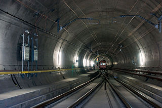
The Gotthard Pass or St. Gotthard Pass at 2,106 m (6,909 ft) is a mountain pass in the Alps traversing the Saint-Gotthard Massif and connecting northern and southern Switzerland. The pass lies between Airolo in the Italian-speaking canton of Ticino, and Andermatt in the German-speaking canton of Uri, and connects further Bellinzona to Lucerne, Basel, and Zurich. The Gotthard Pass lies at the hearth of the Gotthard, an important north-south axis in Europe, and it is crossed by three major traffic tunnels, each being the world's longest at the time of their construction: the Gotthard Rail Tunnel (1882), the Gotthard Road Tunnel (1980) and the Gotthard Base Tunnel (2016). With the Lötschberg to the west, the Gotthard is one of the two main north-south routes through the Swiss Alps. Since the Middle Ages, transit across the Gotthard played an important role in Swiss history, the region north of Gotthard becoming the nucleus of the Swiss Confederacy in the early 14th century.

Lukmanier Pass is a pass in the Swiss Alps.

Pizzo Rotondo is a mountain in the Lepontine Alps. At 3,190 metres above sea level, it is the highest mountain lying on the border between the cantons of Ticino and Valais, as well as the highest summit of the Lepontine Alps lying between Nufenen Pass and Lukmanier Pass.

The Chüebodenhorn is a 3,070 metres high mountain in the Lepontine Alps, located on the border between the cantons of Valais and Ticino. It is situated south of Passo di Rotondo, where a glacier named Ghiacciaio del Pizzo Rotondo lies at the foot of its north face. The south side (Ticino) overlooks the valley of Bedretto.

Pizzo Centrale is a mountain in the Lepontine Alps, located on the border between the cantons of Uri and Ticino. At 2,999 metres above sea level, it is the highest summit overlooking Gotthard Pass from the east. Lago della Sella is located on its southern side. Over its northern side lies a glacier, named Ober Schatzfirn.

Pizzo Straciugo is a mountain of the Pennine Alps, located on the border between Switzerland and Italy. It lies east of the Portjengrat, on the range between the Val Divedro (Valais) and Domodossola (Piedmont).

Piz Timun is a mountain of the Oberhalbstein Range, located on the border between Italy and Switzerland. On its eastern side it overlooks the artificial lake Lago di Lei.

The Cima della Bondasca or Pizzo del Ferro centrale is a mountain in the Bregaglia Range (Alps), located on the border between Italy and Switzerland. Its summit is the triple watershed between Valle del Ferro (Italy), Val Bondasca and Val d'Albigna (Switzerland).
Pizzo di Porcaresc is a mountain of the Lepontine Alps, located on the border between Switzerland and Italy. Its summit is the tripoint between the Valle dell'Isorno, the Valle di Campo and the Valle di Vergeletto.
Pizzo di Madéi is a mountain of the Lepontine Alps, located on the border between Switzerland and Italy. It lies between the valleys of Vergeletto (Ticino), Isorno and Onsernone (Piedmont).

The Rosso di Ribia is a mountain of the Lepontine Alps, located in the canton of Ticino, Switzerland. with a height of 2,547 metres above sea level, it is the culminating point on the range between the Valle di Campo and Valle di Vergeletto. The Rosso di Ribia lies five kilometres east of Pizzo di Porcarese, where the border with Italy runs.

Pizzo dell'Uomo is a mountain of the Lepontine Alps and part of the extended Saint-Gotthard Massif, located between Lai da Sontga Maria and Pizzo del Sole, in the canton of Ticino, just southwest of the Passo del Lucomagno. The border with the canton of Graubünden runs on the northern foot of the mountain, although it lies on the main Alpine watershed, between the basin of the Rhine and that of the Ticino.
Pizzo di Cadrèigh is a mountain of the Swiss Lepontine Alps, located west of Olivone in the canton of Ticino. It lies south of the Scopi, between the Val di Campo and the Valle Santa Maria.

Pizzo Lucendro is a 2,963-metre-high (9,721 ft) mountain in the Lepontine Alps, located on the border between the cantons of Uri and Ticino. It overlooks St. Gotthard Pass and Lake Lucendro on its east side.

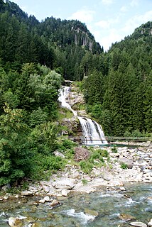
The Rein da Medel is the longest headwater of the Rhine. It is located in the Swiss cantons of Ticino and Graubünden and flows through the valleys Val Cadlimo and Val Medel. Rein da Medel is the local Sursilvan, name in Graubünden, which is commonly used to denote the Ticino part as well.
The Campolungo Pass is an Alpine pass connecting Fusio and Prat in the Swiss canton of Ticino. With a height of 2,318 metres above sea level, the Campolungo is the lowest pass connecting the valleys of Maggia and Leventina.
Pizzo di Campel is a mountain of the Lepontine Alps, located south-east of Soazza in the canton of Graubünden. It lies on the range between the Val de la Forcola and the Val de Montogn.
The Passo della Teglia (1385 m) is a mountain pass in the Province of Imperia (Italy). It connects Rezzo with Molini di Triora.