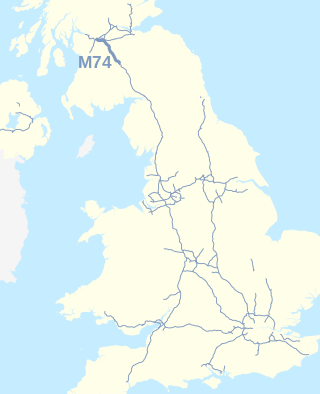
The A74(M) and M74 form a major motorway in Scotland, connecting it to England. The routes connect the M8 motorway in central Glasgow to the Scottish-English border at Gretna. In conjunction with their southward continuation, the M6 motorway, they form one of the three major cross-border routes between Scotland and England. They are part of the unsigned international E-road network E05. Although the entire route is colloquially referred to as the M74, for more than half its length, south of Abington, the road is officially the A74(M); see naming confusion below.

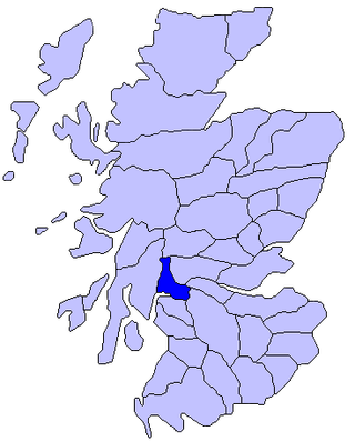
The M77 motorway is a motorway in Scotland. It begins in Glasgow at the M8 motorway at Kinning Park, and terminates near Kilmarnock at Fenwick, becoming the A77 dual carriageway. Changes were made in 2005 segregating a lane on the M8 motorway almost as far as the Kingston Bridge, which in January 2006 was extended further onto the bridge itself. It forms the most northerly part of the A77 trunk road which links Glasgow to Stranraer in the South West of Scotland.

European route E22 is one of the longest European routes. It has a length of about 5,320 km (3,310 mi). Many of the E-roads have been extended into Asia since the year 2000; the E22 was extended on 24 June 2002.

Simshill is an area of Glasgow, Scotland. It is on the South Side of the city, approximately 3.7 miles (6.0 km) south of the city centre. Adjacent areas are Cathcart, King's Park, Croftfoot and Castlemilk. Linn Park is to the south-west of Simshill.
Gogarloch is a residential area within South Gyle, Edinburgh, Scotland. It lies near South Gyle railway station and South Gyle Broadway, 4+1⁄2 miles (7.2 km) west of the city centre. Corstorphine and Wester Broom are nearby.

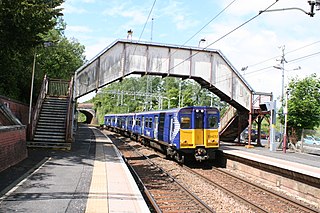
Williamwood railway station is a railway station in the Williamwood area of the town of Clarkston, East Renfrewshire, Greater Glasgow, Scotland. The station is managed by ScotRail and lies on the Neilston branch of the Cathcart Circle Lines. The line here forms the boundary which separates Clarkston and Giffnock.
Patterton railway station is a railway station serving the Patterton, Crookfur and Greenlaw areas of the town of Newton Mearns, East Renfrewshire and the Deaconsbank and Jennylind areas of the Glasgow City council area, Scotland. The station is managed by ScotRail and lies on the Neilston branch of the Cathcart Circle Lines, 7+3⁄4 miles (12.5 km) southwest of Glasgow Central.
Ballybogy, or Ballybogey, is a small village and townland in County Antrim, Northern Ireland. It is located 7 km north-north-west of Ballymoney and 7 km east of Coleraine, lying within the Causeway Coast and Glens district. It is known as Boggie in Scots. It had a population of 539 people
Toad River Hot Springs Provincial Park is a provincial park in the north of British Columbia, Canada. The hot springs are located on the lefthand bank of the Toad River, outside of the Racing River outflow. The area is rugged and remote, accessible only via hiking, riverboat, horseback, or helicopter. There is no actual bathing pool; visitors are advised to not attempt bathing, as heavy mud is a strong presence in the area. Entrance to this area is very difficult, with the crossing of private property being a likely factor, unless accessed by boat or air. Land access is most easily accomplished by horse or by hiking from the Stone Mountain Safaris parking lot. It is recommended that the lodge owners are contacted and made aware of any human presence in the area beforehand. They are very friendly and will always give advice as to how to traverse the area’s wilderness.

Partick West railway station was a station that served the Partick area of the city of Glasgow, particularly the Thornwood section of Partick from 1896 to 1964. It was a four platform station on the Lanarkshire and Dunbartonshire Railway, with two platforms on an east–west line with services between Dumbarton and Glasgow city centre and a further two platforms on a north–south line with services between Maryhill and the city centre.

Deaconsbank is a neighbourhood in the Scottish city of Glasgow. It is situated south of the River Clyde. The main feature of the area, which falls into the Greater Pollok ward of Glasgow City Council and directly borders the East Renfrewshire council region, is an estate of around 639 private houses built in the late 1970s by Barratt Developments, prior to which the area was open farmland. Deaconsbank is bordered by the M77 motorway to the west and by Rouken Glen Park and golf course to the east. The northern parts of the suburban town of Newton Mearns are a short distance to the south, as is Patterton railway station.
Point Leamington is a town of about 590 people located north of Botwood and Grand Falls-Windsor in the Canadian province of Newfoundland and Labrador.

Goose Cove East is a town in the Canadian province of Newfoundland and Labrador. The town had a population of 172 in the Canada 2021 Census.
Point of Bay is a town in the Canadian province of Newfoundland and Labrador. The town had a population of 154 people in 2016, down from 163 in the Canada 2006 Census.
Woodstock is a town in the Canadian province of Newfoundland and Labrador. The town had a population of 195 in 2021, up from 190 in the Canada 2016 Census.

Roughmussel is a neighbourhood in the Scottish city of Glasgow. It is situated south of the River Clyde near to the city boundaries with East Renfrewshire to the south and Renfrewshire to the west.
Ladyburn distillery was a producer of single malt Scotch whisky that operated between 1966 and 1975.

The borders of the oceans are the limits of Earth's oceanic waters. The definition and number of oceans can vary depending on the adopted criteria. The principal divisions of the five oceans are the Pacific Ocean, Atlantic Ocean, Indian Ocean, Southern (Antarctic) Ocean, and Arctic Ocean. Smaller regions of the oceans are called seas, gulfs, bays, straits, and other terms. Geologically, an ocean is an area of oceanic crust covered by water.